How the Purple Line will fit through the Silver Spring Transit Center
The Purple Line and the Capital Crescent Trail/Metropolitan Branch Trail will both have to fit through the Sarbanes multi-modal transit center, currently under construction. So far, the maps and plans haven’t made clear how the Metro line, CSX tracks, trail, and Purple Line can all fit. Based on MTA drawings, they plan to accomplish this by building an elevated Purple Line above the trail through the transit center and over to Bonifant Street.

Looking north at the Silver Spring Metro Station from the north end of the MARC platform. (Nov. 4, 2009)
The concept plan to bring the future Capital Crescent Trail into the new transit center from the north end is easy to envision. There is room for the trail to be built along the east side of the CSX/Metro tracks and at about the same level as the CSX tracks, to be supported on a new elevated trail structure. The Purple Line will also be coming into the center from the north end and on the same side of the CSX/Metro tracks as the trail, but supported on new structure at a higher level than the trail.
The Purple Line must be much higher as it enters the station from the north, because the Purple Line must cross over the CSX tracks from the west to east side immediately north of Colesville Road. Under CSX rules, the Purple Line structure must clear the CSX tracks by at least 27’ at the cross over bridge. Light rail tracks cannot change elevation quickly, so the Purple Line will remain well above the future CCT as it comes into the transit center from the north side of Colesville Road.

The Purple Line tracks and station platform will be along the east (right) side of the CSX tracks, and higher than the “gull wing” roof over the Red Line Metro platform.
But what about from the south? I had assumed the Purple Line would be gradually dropping elevation as it approached the south end of the transit center, to come much closer to the trail elevation. MTA and County planners had given their assurance that space had been reserved for both the Purple Line and trail, but it wasn’t clear how the south end of the MARC platform, the two Purple Line tracks, and the Met Branch Trail could all fit between the CSX tracks and the new transit center bus platforms if they were at about the same level. And there was the problem of how to have the Purple Line cross the Met Branch Trail as the Purple Line made its turn east toward Bonifant Avenue. The MTA transit center renderings to date don’t show anything to clarify this.
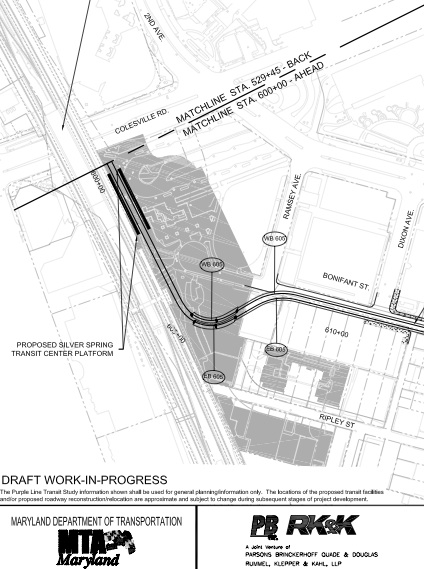
The Purple Line alignment at the transit station. Source: www.purplelinemd.com (See LPA-13 at “Conceptual Plans”; See LPA-12 for alignment over Colesville Road)
The MTA conceptual plan above shows where the Purple Line will turn east at the south end of the transit center. The Met Branch Trail is not shown. It will be along the east side of the CSX corridor as it enters the transit center area from the south.
MTA engineers commented at the MTA Purple Line focus group meeting for downtown Silver Spring on Nov. 2 that it would be tight for them to bring the Purple Line “down” to meet the elevation of Bonifant Street after leaving the transit center and turning east. The Purple Line must meet the existing Bonifant Street elevation east of Ramsey Avenue to continue east on dedicated lanes on the south side of Bonifant Street. But Bonifant Street is much higher than the CSX track elevation, so why is it a tight fit to bring the Purple Line elevation down to Bonifant Street?
The MTA Purple Line elevation drawing in this area (available online at www.purplelinemd.com at Maps and Graphics / Conceptual Plans / PDF file LPA-47) shows the tracks staying at a constant high elevation through the transit center and then rising as the Purple Line begins the turn east toward Bonifant Street, to stay well above the ground level. The highest point for the Purple Line tracks is near the middle of the turn. The Purple Line will then stay high, and even climb a little at the south end of the new transit center, to accommodate a new Bonifant Street/Ramsey Avenue road connection called for in the Ripley area development plans.

“Midtown Silver Spring” site in the Ripley development area. Source: Planning Board Sept. 18, 2008 archived agenda (PDF file at item #5)
The Montgomery County Planning Board has approved site plans for tall residential buildings on both sides of Ripley Street — the “Midtown Silver Spring” project shown above and also a “1050 Ripley” project immediately opposite on the south side of Ripley Street. Site plans for both projects show similar plans for Ripley Street to be extended to connect to Bonifant Street, to improve area street circulation.

Plan to extend Ripley Street to Bonifant Street, room is reserved for the Met Branch along the CSX tracks (trail not shown). Source: Planning Board July 3, 2008 archived agenda (PDF file at item #4)
The highest Purple Line elevation shown in the MTA conceptual drawing corresponds to the location over the Ripley Street extension where the extension comes out at the end of Bonifant Street. The Purple Line is more than 20 feet above the existing ground elevation there, to allow the Ripley Street extension to pass under the Purple Line. The Purple Line will begin to descend to meet the grade of Bonifant Street after it has cleared the Ripley Street extension.

Looking up toward Bonifant Street from the MARC platform. The Ripley Avenue extension and Met Branch Trail will be at grade,
while the Purple Line tracks will be elevated.
In brief, the CCT/Met Branch can stay at the same level as the CSX/Metro tracks through the transit center and beyond. The Purple Line is planned to stay much higher through the transit center and around the first part of its turn east at the south end of the transit center. The Met Branch Trail can easily pass under the Purple Line at the south end of the transit center, for a straight and grade separated crossing. Because the Purple Line stays elevated, the trail can be partially under the Purple Line structure through the entire transit center to make room for more than a full width trail within the space reserved for the project.
This is only a concept plan at this time. It is a long way to final design and construction. But it is reassuring to see the MTA Purple Line plans and the County area development plans are consistent with each other and will support a direct, level CCT/Met Branch Trail alignment with no at grade crossings of either roads or rail.