An “Abe’s to Ben’s” Circulator could connect tourists to DC neighborhoods
The National Park Service plans to create a new Circulator route around the National Mall. NPS and the city could also improve transit options to nearby neighborhoods with a line from the Mall to Foggy Bottom, Dupont Circle, and U Street.
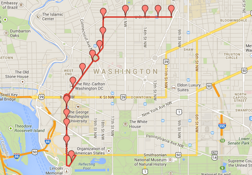
Our proposal for the “Abe’s to Ben’s Circulator.” Click for an interactive map.
The Advisory Neighborhood Commissions (ANCs) for Foggy Bottom and Dupont Circle have voted to ask NPS and the city to consider such a route, which we have nicknamed the “Abe’s to Ben’s” or “A to B” route.
The planned Mall Circulator route, which NPS plans to fund in part with revenue from new parking meters along the Mall and in West Potomac Park, is an excellent beginning and will improve transit accessibility to some of DC’s most popular attractions.
At the same time, the route, which goes east-west along the Mall to and from Union Station, doesn’t give tourists an easy path off the Mall and into the neighborhoods to support our local businesses.
More than 4 million tourists visit the Vietnam Memorial and the Lincoln Memorial, two of the most popular landmarks, each year. But the area still has poor transit service, with little Metrobus service and the nearest Metro station ¾ of a mile away.
Our proposal
The “Abe’s to Ben’s” line would begin at the triangle in between 23rd Street NW and Henry Bacon Drive, by the Lincoln Memorial. The bus would then travel north along 23rd Street and provide service to the State Department, Columbia Plaza, and George Washington University’s main campus before meeting up with the Blue and Orange lines at the Foggy Bottom-GWU Metro station at 23rd and I Streets.
From there, it would proceed up New Hampshire Avenue and around Washington Circle to the southern entrance to the Dupont Circle station on the Red Line. It would continue around the circle to 18th Street and travel north to U Street before heading east to the U Street Metro station, the Green and Yellow lines. It could then end near the African-American Civil War Memorial (linking Park Service sites at each end) or Howard University.
This Circulator route would improve transit connections for both residents and tourists, providing a one-seat ride between the Mall, downtown, and mid-city neighborhoods. It would provide a direct connection to all 5 Metro lines, a crucial reliever of core Metro capacity and an alternative during service disruptions.
It would also restore bus service on the east side of Dupont Circle which ceased two years ago when Metro re-routed the L2 away from 18th Street. With this proposal, all of the bus pads that were installed as part of the streetscape project on 18th just a couple of years ago can serve a purpose again.

An L2 bus (formerly) stops on 18th Street. Image from Google Street View.
What about other routes?
DDOT’s 2011 Circulator master plan envisions extending the current Rosslyn-Dupont route to the U Street and continue the National Mall route up 23rd Street and over into Georgetown by way of Pennsylvania Avenue.
There are better ways to expand service. An extension of the Mall Circulator into Georgetown would be redundant with the 31 Metrobus, but with less utility since the 31 serves the entirety of the Wisconsin Avenue corridor up to Friendship Heights.
Extending the Rosslyn-Dupont route, on the other hand, raises issues about service reliability and neglects to serve Foggy Bottom and the National Mall. The current route already must traverse congested L and M through Georgetown and the West End.
Our proposal introduces a more direct, less traffic-choked connection to the Blue and Orange lines for Dupont and mid-city residents, while implementing service in areas of Foggy Bottom that don’t have good transit service.
Our proposal isn’t perfect. We’re not transit professionals; we’re community activists looking to improve connectivity between our neighborhoods in a way that reduces automobile dependence and hopefully serves many of the city’s goals.
We know, for instance, that there many not be enough demand for Circulator service on the National Mall at 11 pm on a Saturday, but there may be a lot of demand in U Street and Dupont Circle. We also would love to extend this route proposal farther east to Howard University, with its transit-dependent student population. We welcome suggestions as to how to resolve these, and other, potential dilemmas.
Next steps
Tonight, February 25th, DDOT will hold its semi-annual forum on the Circulator, where members of the public can comment on future service. This is a critical opportunity to ask agency officials to consider our proposal.
Despite the long road and uncertainty that lies ahead, we feel that this idea is one worth sticking with and fighting for. It would benefit residents, workers, and tourists alike, while providing benefits for local businesses and inducing additional tax revenue for the District.
Now that the National Park Service has changed the rules of the game, it’s time to examine the opportunities, and provide better transit options for everyone.