6-year study suggests tweaks around 14th Street bridges
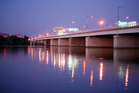
Photo by { JHGagle | Photo } on Flickr.
Near the Jefferson Memorial, 5 bridges cross the Potomac carrying motor vehicles, bicycles, pedestrians, the Metro, and freight and passenger trains. How can they be improved?
The Federal Highway Administration, DDOT, VDOT, and the National Park Service have been working on an Environmental Impact Statement (EIS) for the 14th Street Bridge corridor since 2006. They looked at the roads and paths on the bridges themselves and for some distance on and around I-395 and Route 1 (14th Street and Jefferson Davis Highway).
The study started with a long list of ideas from a number of public meetings, from double decking the 14th Street bridge or building a circumferential Metro line, to instituting cordon pricing or tolls, to painting murals on the concrete walls.
They analyzed a number of options and condensed them down to 3 bicycle and pedestrian options, 4 roadway options, and 6 Transportation Demand Management options. This post looks at the roadway and TDM alternatives; the next one will delve into the bicycle and pedestrian options.
Vehicular options
One of the most significant conclusions from the draft EIS is what it chose not to recommend: More single-passenger vehicle capacity. The team looked at adding new general-purpose lanes (which, on a freeway-type bridge, aren’t as much “general purpose” as “motor vehicle only”) or HOT lanes. Once Virginia decided not to run HOT lanes through Arlington, the HOT lane options became moot, and adding new auto capacity generally did not reduce congestion.
There are 5 remaining proposals that would affect motor vehicles:
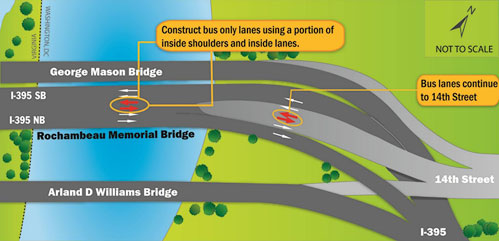
Add a bus lane. A lot of commuter buses drive to the Pentagon and then over the 14th Street bridge to DC, and many local buses also cross in this area. This alternative would use the existing shoulder of the Rochambeau bridge (the center of the 3 road bridges, which carries the express lanes in both directions) for a bus lane, and convert one lane on 14th Street to a bus lane.
The heavy volume of buses moves a great many people in this corridor. Helping buses bypass congestion and give riders a quicker ride would further improve the value of taking transit from many parts of Virginia.
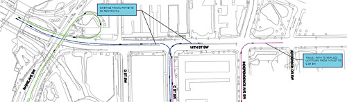
Ban left turns at 14th and C (at a cost of about $203,000). C Street SW ends at 14th, in the last intersection with a traffic signal before the bridge. The study says that giving time for vehicles to turn left from southbound 14th onto C, or left from C onto southbound 14th, creates significant delay, and this option would forbid these turns. Drivers would only be able to turn right in or out of C.
Click to enlarge (PDF).
On its own, this sounds like a bad idea because it would move further away from a functional grid in this area, and make 14th more like a freeway. It could, however, be a reasonable way to reduce some of the extra delay that comes from the bus lane option, making that a little more palatable.
The most important question, which the report does not specify, is how this would affect pedestrians. People cross on foot to get to and from the Holocaust Museum, for instance, and already the signal here forces them to wait long periods of time for the various movements. Removing the left turns could allow more pedestrian crossing time, or it could make things worse, depending on the final signal timings.
DC should also add a marked crosswalk along the south side of this intersection, where there is none today. Every side of every intersection ought to have a marked crosswalk, regardless of its effect on traffic, but an animation of the proposal makes it appear that there would be no traffic effect with left turns prohibited, anyway.
For the final EIS, the team should investigate pedestrian crossings and suggest timings that help them cross more safely and with a shorter wait.
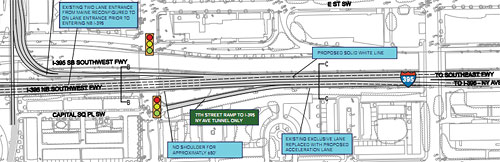
Restripe around Maine Avenue, 7th and 9th Streets ($185,000). There are a lot of ramps on and off in this area, creating a lot of merging and weaving. This option would narrow the on-ramp at Maine Avenue to 1 lane instead of 2, reducing the amount of merging on the freeway itself.
Also, it would add a solid white line between some of the freeway’s lanes east of 9th Street. Drivers getting on at 7th Street would only be able to then continue to the 3rd Street tunnel (the one that goes under the Mall to New York Avenue, also signed as I-395), and drivers getting on from 9th Street would have to continue onto the Southeast Freeway (now signed as 695) instead. Drivers might ignore this line, but FHWA hopes it will decrease weaving.
Click to enlarge (PDF).
Remove some ramps on the Virginia side ($2.7 million). There are 10 ramps on and off 395 right around the Pentagon, also creating a lot of merging and weaving. This alternative suggests removing the ramps from 395 northbound to the GW parkway northbound, and the matching ramp from the GW Parkway southbound to 395 southbound. Drivers can still get where they need to go by taking Washington Boulevard (Route 27) instead, which is actually shorter, anyway.
In addition, this alternative would change around the ramps at Boundary Channel Drive, the access road to the Pentagon north parking lots. Now, there are cloverleaf-style ramps on and off of 395 southbound, so that cars coming from or going to each direction of Boundary Channel have their own ramps.
Instead, the ramps in the southwest quadrant would go away, and the northwest quadrant ramps changed so that cars can turn in either direction on and off of Boundary Channel.
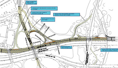
Ramps in gray would be removed. Click to enlarge (PDF).
Arlington has proposed another option to add roundabouts instead of traffic signals at the ends of the ramps.
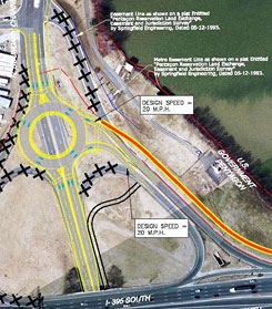
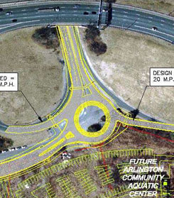
Potential roundabouts on each side of 395. Click to enlarge (PDF).
Transportation Demand Management options
Reconfiguring roadways is not the only way to reduce congestion. Transportation Demand Management is the field concerned with helping people better understand their travel options besides solo driving. Maps, real-time information, and public service ad campaigns can help people choose transit. Employers can provide incentives or assistance for people to carpool, telecommute, or commute outside peak hours.
The TDM options that the DEIS proposed to carry forward to the final version include:
- Expand incentives for telecommuting
- Expand flexible work hours
- Increase prices for parking and/or decrease supply
- Better coordinate among agencies along the corridor (Federal, District, state, and local) to share information and respond to crashes or other incidents
- Create a program to educate drivers in the corridor in “[crash] avoidance maneuvers and defensive driving skills”
- Make signs better and more consistent across the corridor
The study team is accepting comments on the draft EIS until March 15th. They will then begin work on the final EIS. I will send them all comments made on this post through at least the end of Wednesday, March 14. If you want to send them your own, more detailed comments, you can do so through this form.
The bicycle and pedestrian proposals, meanwhile, are worth a whole discussion on their own. Part 2 will examine these in detail.