What’s better: A $3 million direct trail or a $6 million detour?

Photo by Richard Drdul on Flickr.
Anne Arundel County wants to fill a gap in the Washington, Baltimore, and Annapolis Trail with a circuitous $6 million path, instead of the better and cheaper direct option.
This week, Maryland Governor Martin O’Malley will announce a new state program to help local governments fund trail construction. The first project on tap is path and bridge over the Patuxent River to connect the WB&A segments in Prince George’s and Anne Arundel counties.
The two counties are a mile apart on where that bridge should be. Prince George prefers a $3 million bridge with a straight trail along an old railbed. But Anne Arundel prefers a $6 million bridge with a detour that goes up and down a hill, runs through a wetland flood plain, and adds a mile to the length of any trip. Recently, state officials have been moving forward with the more costly alignment.
The state would be picking up a large portion of the inflated tab. Will the Governor merely provide funds to enable local decision-making at its worst, or will he lead these counties to build the better, lower-cost trail that, for a variety of institutional reasons, they are unable to pursue on their own?
The Washington, Baltimore, and Annapolis Trail runs along the right of way of the old railroad of the same name from Lanham to the Patuxent River in Prince George’s County, a distance of about 6 miles. One mile northeast of the Patuxent, the trail picks up again and continues for 4 miles to Odenton. From there, you can take mostly local streets to connect to the BWI Airport and Trail.
Anne Arundel County is preparing to build a trail along the South Shore Line of the old WB&A railroad from the eastern end of the WB&A trail to Annapolis. Meanwhile, Prince George’s County plans to build a trail from the western end of the WB&A Trail to Bladensburg and the Anacostia River Trail. Building the connection over the Patuxent River to connect the two segments of the WB&A Trail is thus the highest priority in the Missing Links Program at the Maryland Department of Transportation (MDOT).
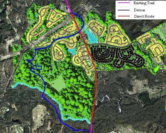
Anne Arundel’s detour and the direct alignment.
The land between the two trail segments is undeveloped. A single developer owns the old railbed for about half the distance, and the land next to the railroad right of way for the other half. As part of the permit process for the planned Preserve at Two Rivers, Anne Arundel County could easily extend the trail in a straight line to the water’s edge.
Instead, the County wants the developer to build a winding detour that would reach the Patuxent River on the Anne Arundel side about a mile north of where the trail currently reaches the river on the Prince George’s side. Under the proposed site plan, the development will also place homes atop the old right of way, and thereby ensure that a straight trail is never built.
Railroads were always good at finding the route with the most favorable topography. Thus, the old railbed would provide a gradual slope down to the river. The detour would send the trail first up a small hill, then down a steep incline toward the river.
The route down to the river is so steep it requires several switchbacks. According to officials who attended a meeting on the subject in September, the turns are so sharp that the maximum safe speed is 7 mph, and the steep slopes do not comply with the Americans with Disabilities Act. Then, at the bottom of the hill, the detour trail would have to cross several hundred feet of floodplain wetlands before reaching the river.
Why does Anne Arundel County prefer a costly detour that seriously degrades the quality of the trail? I have been unable to find any official willing to offer a clear rationale.
According to Ken Alban, Chief of Capital Projects for the parks department, the county is pursuing the detour because a decision was made to pursue the detour years ago, before he took his position. “I have many projects and I cannot be continually revisiting the rationale behind each one, or nothing would ever get built,” he says.
The detour alignment was originally proposed at the turn of the century by Buz Meyer, who owned the land along the Patuxent River immediately southeast of the railbed. Both the County and Meyer claimed ownership of the railbed itself.
Several officials who were with the county ten years ago told me that the decision to pursue the detour was made around 2001 by then-County Executive Janet Owens. Until then, the County had planned to run the trail on the right of way, but it eventually conceded that the right-of-way within about 1000 feet of the river was owned by Meyer.
Why didn’t the county simply move the trail alignment by about 50 feet from the old roadbed to the adjacent parcel to the northwest? Three county officials told me that Meyer did not want the trail near his land because of the risk of stray bullets from his property, which was used for hunting and firearms training.
Apparently the detour was the only alternative in 2001. But circumstances have changed. A developer now owns the land northwest of the railbed. And Buz Meyer died recently. His son, Andrew Meyer, told me that he opposes the trail being on his property, but that he does not care if a trail is on the adjacent parcel, as long as people do not trespass on his land.
A fence could easily be built. In fact, a high wall was built to stop bullets and trespassing where the WB&A Trail runs along the grounds of the Berwyn Rod and Gun Club in Bowie.
Mr. Alban asked me why cyclists would want this more direct route. I told him it would allow people to arrive at their destination 10 minutes sooner. He told me he was surprised: “No one has ever suggested to me that this trail will be used for transportation,” he said. “I doubt that people will use this trail for commuting.”
Prince George’s County has consistently favored the direct trail and opposed the detour since 2001, when then-county executive Wayne Curry sent Owens a letter explaining the the County’s position.
A few years ago, Prince George’s added a ½-mile segment extending the trail to the water’s edge, which would be superfluous if the detour trail was built. County park and planning staff continue to favor the direct connection. But after a decade, they have also become pessimistic about whether it will ever be completed. So they are building a short trail along another old rail spur that would facilitate the detour, should it become the only option.
State officials almost universally are skeptical about the detour, but feel that there is nothing they can do even though the prospect of state funds is driving the process. Steve Carr of the Department of Natural Resources told Maryland’s Bicycle and Pedestrian Advisory Committee that because the detour runs through wetlands in a floodplain, the permit process could take years.
I asked whether the state can do a complete alternatives analysis and pick the optimal route in a public process. “If and when the state conducts a design study, it can conduct an alternatives analysis,” said Dustin Kuzan, the state’s bicycle and pedestrian coordinator.
“But what if Anne Arundel County and the planned development make the direct route far more costly before that study begins,” I asked. “We may not fund the best option, but the state can not make local land use decisions,” he said.
Maryland is thinking of funding a wasteful detour bridge that makes no sense today, because the detour was the only practical alternative ten years ago. Middle management apparently lacks authority or incentive to pursue the more valuable and lower-cost alignment. MDOT needs leadership from Governor O’Malley to ensure the state doesn’t waste money building an inferior trail.