WMATA wants longer trains, more tunnels, better service
WMATA hopes to lengthen all its trains to 8 cars, add pedestrian connections at downtown stations, and maybe build new rail tunnels for the Blue and Yellow Lines in the region’s core. That’s part of a strategic plan which its media relations team showed only to the Washington Post this week, and which board members will see at a meeting today.

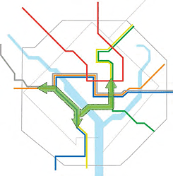
The potential for new downtown tunnels (left) and connections between existing lines (right).
More broadly, the agency will focus on safety, service quality, better regional mobility, and its own financial stability in the strategic plan. Besides a set of still somewhat amorphous connections and service improvements, the plan calls for building a system where riders can more easily “plan, pay, and ride” in a smoother customer experience.
The big money, up to $20 billion, in the plan would be for tunnels to separate the Blue Line at Rosslyn and the Yellow Line at L’Enfant Plaza, the two major chokepoints, as part of a vision for Metro by 2040. Silver Line trains from Dulles Airport could also turn at Rosslyn to go toward Arlington Cemetery, then stop at Pentagon before crossing the Yellow Line bridge into DC.
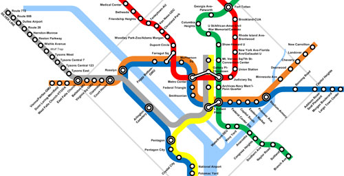
Map by the author, from 2009.
By 2025, Metro wants to have the railcars and power stations to run all trains with the full 8 cars. It would like to build pedestrian tunnels to link Farragut North with West and Metro Center with Gallery Place, and a train tunnel so that some Dulles trains can go down to Franconia-Springfield, which would relieve some of the immediate Blue Line problems of Rush Plus, which will only get worse once the Silver Line opens.

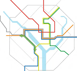
Potential connections between existing lines (left) and stations (right).
WMATA Media Relations team makes transit supporters’ task harder
This plan covers a lot of ground, and is at times very detailed yet at others quite vague. I wasn’t able to get all of the details, because WMATA decided to give an exclusive look at the plan to the Washington Post.
This has been the agency’s practice every since Barbara Richardson, Lyn Bowersox, and Dan Stessel took over at WMATA communications and media relations. This isn’t a matter of blogs versus traditional media, though that’s been an ongoing problem as well; WMATA also does not tell the Washington Examiner about its major initiatives.
This seems inappropriate, and really disrespects the journalists and bloggers who care about transit in the region. It’s also pretty foolish, because it forces others to write about the plan in a more hurried way than they otherwise would.
WMATA planning head Shyam Kannan spent an hour talking to me after midnight last night, and this post was still not done by 4:30 am as a result. Still, there are plenty of questions I did not have time get answered.
What will happen with Union Station and commuter rail?
While the plan goes into a fair amount of detail about how there could be a second Pentagon station for the trains making the new track connection, the plan does not talk about whether the new lines would serve Union Station, the system’s biggest point of overcrowding. It seems obvious for any separated Blue Line to go there.
One of the biggest opportunities to improve regional travel would be to let MARC trains reach L’Enfant Plaza, where riders can transfer to all four lines that don’t serve Union Station, and onward to Virginia. Unfortunately, perhaps bowing to political realities, the plan just calls for WMATA to play a role of supporter and advocate.
Finally, the plan shows some diagrams with vague arrows depicting potential extensions to the ends of lines, regional transit in the suburbs, and streetcars crossing the river:

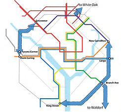
Vague arrows showing possible line extensions (left) and surface transit connections (right).
All of these ideas and more were part of a study WMATA has been working on for a few years, called the Regional Transit System Plan. That also included proposals to send the Yellow Line through the rapidly-growing Capitol Riverfront and up to Union Station.
According to Kannan, the RTSP study is still going on, and even many decisions about which routes WMATA wants to pursue in the future are not fully set.
Customer service, trip planning are even more central to the plan
Kannan emphasized that the rail expansions and connections are not the “real meat” of the plan, despite what was in the Post article; instead, it really focuses on “an improved customer service experience today” that will let riders plan, pay, and take transit more smoothly than today. The vision for 2025, which is not far away, is fundamentally about “the completion of a journey to a self-service system. He explained:
Imagine, for a moment, walking into a Metrorail station or a Metrobus platform and not needing to ask for assistance in either route planning, fare payment, and even walking to or from your bus or train. There would be improved lighting so you can read your book, mobile payment options so you can use your smartphone to pay your fare.
With these added services, Kannan said, station agents will not need to sit in their booths all day to handle everyday needs. Instead, Metro could dedicate its staff to “customer-facing ambassadors” who could roam around and help people, and choose people for those jobs best suited to a customer service role, which as we all know is not always the case with today’s station agents.
Another big element of this self-service world is better trip planning. Kannan talked about having a “unified regional trip planning technology” so a rider can use a desktop computer, smartphone, or other device, pick where he or she wants to go, and get transit suggestions that could use Metro, commuter rail like VRE or MARC, or regional buses like Ride On and DASH.
The plan describes that as “Provide transit riders with a regional trip planning system that is mobile-device friendly.” Hopefully this language does not lead the agency to decide it should issue a procurement for a big IT project to build one single integrated trip planner that works on today’s mobile devices, and that’s all. WMATA is not in a position to be a good customer-facing software company, and a big contracted software project will build something that will likely be obsolete as soon as it launches.
Rather, the agency needs to offer open data and support open source projects to create the building blocks of trip planning. VDOT funded a grant, which I wrote for Arlington County, to make progress on some open source technology for trip planning. If WMATA can support the efforts of the people who are going to do this work, and other developers who contribute and create other tools of their own, it will do far more to “provide” this kind of “unified regional trip planning technology.”
The plan is not very detailed about how to reach this or most other goals, from “Educate the customer about transit coverage and usage in regional emergencies” to “Work with partners to ensure seamless connections between Metro and other transit systems in the region.” Those are fodder for future plans. Meanwhile, though, if top management buys in and directs the organization to follow this plan, it can get the 13,000-person organization moving all together in some important directions.
The WMATA board will discuss the document at a meeting today. As usual with WMATA’s process, since staff don’t release anything until the very last minute before a board meeting, that means board members won’t have the opportunity to hear any considered feedback from riders, to the extent they are interested in riders’ views, as some are, while others are not.
Matt Johnson and I have also been working on some posts about the core capacity Metrorail proposals, and will try to better illuminate what kinds of tradeoffs Metro faces as it tries to deal with its bottlenecks and overcrowded segments.