Baltimore looks to right-size Druid Park Lake Drive
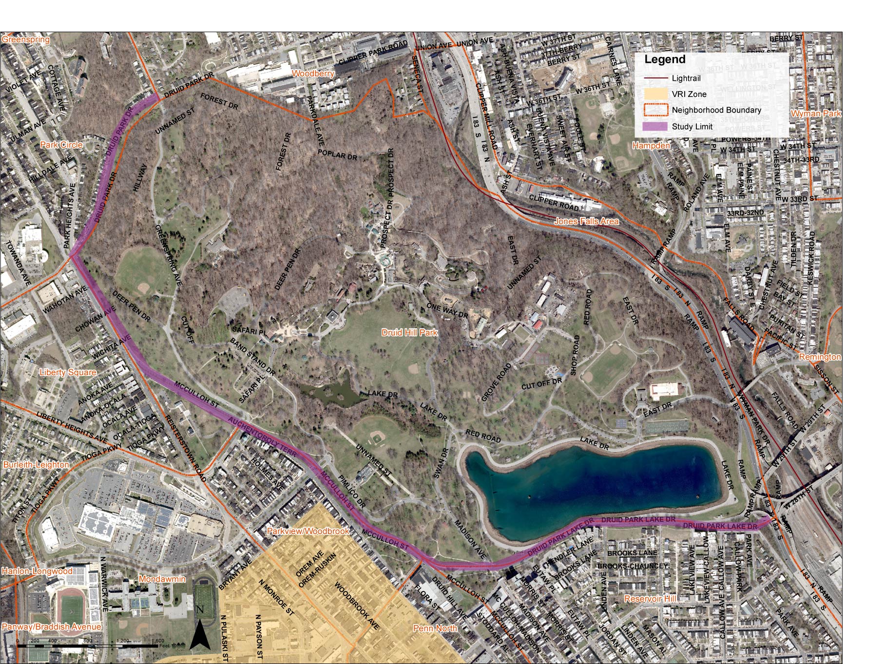
A map of Druid Park Lake Drive (in purple) by Baltimore City Department of Transportation.
Even by the checkered standards of Baltimore history, Druid Park Lake Drive stands out as one of the city’s biggest urban planning mistakes. Despite its relatively short length, the highway-like road which runs along the southern edges of Druid Hill Park in northern Baltimore has had an outsized impact on its surrounding neighborhoods for almost 75 years: cutting off residents’ access to transit, jobs, and recreation, increasing motorists’ speeds at the expense of other transportation modes, and contributing to some of the worst asthma rates in the city.
Four years ago, officials installed an ambitious multimodal path called the Big Jump to help link neighborhoods cut off by the high-traffic street. Now, a proposal by the Baltimore City Department of Transportation (BCDOT) to redesign Druid Park Lake Drive to match Complete Streets principles could offer residents of the three neighborhoods adjoining the road — Auchentoroly Terrace, Mondawmin, and Reservoir Hill — a chance to reclaim the qualities that made the area so desirable in the first place.
Part of the problem with how Druid Park Lake Drive affects its namesake park and the residents who live near it is that it was never really designed with them in mind. Both the drive and one of its adjoining streets, Druid Hill Avenue, were built in the late 1940’s as part of the “Druid Hill Expressway,” intended to help commuters already rapidly moving out towards the suburbs to get to and from downtown Baltimore as fast as possible.
The result was a stretch of road where pedestrians, cyclists, and mobility device users have to cross as many as seven different lanes at a time just to get from Auchentoroly Terrace to Druid Hill Park (while the speed limit is 30 mph, roads with multiple lanes encourage speeding and unsafe driving)
To add insult to injury, the construction of Druid Park Lake Drive reduced the amount of pedestrian entrances to its namesake park from as many as 24 in 1927 to just 8 today. That greatly hampered access to what’s not just one of Baltimore’s most popular gathering spaces but also a key neighborhood source of exercise and fresh food and a gateway to the rest of the city.
“It hinders access to the park,” said Graham Coreil-Allen, President of the New Auchenteroly Terrace Association, of Druid Park Lake Drive. “People could be enjoying a lot more of Druid Hill Park, especially the half of residents who do not have access to cars if we didn’t have it set up like a highway.”
It’s not just pedestrians and cyclists who suffer from Druid Park Lake Drive’s wide lanes and high speeds, either. Coreil-Allen said drivers who park on Auchentoroly Terrace, around the corner from Druid Park Lake Drive, experience vehicle damage because of high speeds. “So we really want to slow those cars down and make it so that it’s a safe neighborhood street and that it respects the residents who live here no matter how you get around,” Coreil-Allen said.
In the fall of 2020, BCDOT hired transportation planning firm WSP to come up with three options for returning the Druid Park Lake Drive corridor closer to what it looked like before the expressway was built. All three concepts have a couple features in common: a 12-foot sidewalk adjacent to residences, three 8-foot “green buffers,” and bookending each option, a 15-foot shared use path adjacent to Druid Hill Park.
But that’s where the similarities end. The first design, by far the most pedestrian and bike-friendly, envisions a 12-foot two-way bike lane in between the first two green buffers and 22 feet of two-way car lanes.
One-lane concept for Druid Park Lake Drive Rendering by Baltimore City Department of Transportation.
By contrast, the second design, while still including the two-way bike lane, also calls for 42 feet of space for cars, with two lanes in each direction.
Two-lane concept for Druid Park Lake Drive Rendering by Baltimore City Department of Transportation.
The third concept, intended to be somewhat of a compromise between the other two designs, would be the largest of the three proposals: it includes a parallel parking lane, a shared lane used by both bikes and cars, a single-direction dedicated bike lane and three car-only lanes.
Hybrid concept for Druid Park Lake Drive Rendering by Baltimore City Department of Transportation.
Unsurprisingly, both local transit advocates and neighbors seem to be overwhelmingly in favor of Option 1. Jed Weeks, the Policy Director/Interim Executive Director for Bikemore — the Baltimore bike and transit advocacy group that helped spearhead the Big Jump — noted that this option most closely mirrors his organization’s findings from a traffic analysis Toole Design did for the path, which reported no traffic delays for cars — traffic actually sped up in one direction at certain hours — and no diversion of traffic into neighboring communities (the Big Jump narrowed the road in a way that loosely mirrors the current proposal).
“Evidence is pretty clear that one lane in each direction works,” Weeks said, “it also reduces crashes, it generally reduces speeds […], it reduces crossing distances, all positives. There was no negative to this ‘one lane in each direction’ proposal. So to me, it makes no sense to come up with alternatives that are potentially worse than that.” ]
Of course, Druid Hill Park Lake Drive’s road diet has its detractors. One group — albeit smaller and less local to the area than the project’s supporters — opposes any attempt to return the Druid Hill Park corridor to something more like its prewar dimensions. The “Save Our Streets Coalition” is a group of about five individuals who, with the exception of former Council President Lawrence Bell, live in slightly further out neighborhoods like Hanlon Park.
The group has essentially thrown the kitchen sink at any efforts to right-size Druid Park Lake Drive, citing fears of gentrification, congestion, ambulances not being able to pass through, “not enough parking,” the idea that Black people don’t really bike, their dislikement of the Big Jump (what they call the “Big Dump”), and Druid Park Lake Drive’s location on their commutes to points further downtown (Ironically, Weeks noted, many of the same individuals have been among the most ardent opponents of the Baltimore Greenway Trails Network because it would pass by some members’ homes on Gwynn Falls Parkway). The Coalition’s opposition has been enough to earn them closed-door meetings with BCDOT and WSP and influence on Options 2 and 3.
But within the Mondawmin, Reservoir Hill, and Auchentoroly Terrace communities, that same opposition seems to have garnered a much more hostile reaction — and not just because the Coalition has taken to carpeting the neighborhoods with leaflets, many of them directly placed into residents’ mailboxes in violation of federal law.
“Many of those who are opposed to this position have told us that it’s going to reduce parking in terms of the Black community and it’s going to reduce parking in terms of the church community,” said Mona Lisa Diallo, a Mondawmin resident and a board member of another prominent neighborhood group, the Greater Mondawmin Coordinating Council. “My response to that is that Black churches, which are on every corner, are truly committed to the community, the community would be walking to the church. They wouldn’t be driving from Baltimore County or Harford County. It doesn’t behoove us to accommodate those that are coming in our neighborhoods on to service for three hours a week and then driving back.”
And as for gentrification, Diallo believes that narrowing Druid Park Lake Drive would actually benefit the renters, single parents, multigenerational families, and other members of marginalized groups, not just the types of people who usually benefit from gentrification because to her mind, those groups are hurt by the current status quo embodied by the road as it exists today.
The public comment period for the Complete Streets redesign of Druid Park Lake Drive wrapped up this past Monday, January 17, having already been extended an extra month from the original deadline in order to allow the Mayor’s Bicycle Advisory Commission to review the proposals. BCDOT and WSP will now work on incorporating the public feedback they’ve gathered into their final report, which will likely be released later this month.
Correction: This article previously stated a traffic analysis of the Big Jump was done by Bikemore. It was completed by Toole Design for BCDOT.