Wheaton residents attracted to Paris-esque features
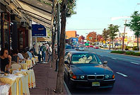
Photo by the author.
In 2001, Montgomery County brought in representatives from the Mass Transit Administration to conduct a “Visual Preference Survey” for downtown Wheaton.
Created by Anton Nelessen, the survey has been in use since the 1970’s as a visioning exercise, determining what kind of places people like or don’t like. It’s been used throughout the country, most recently in Carroll County in 2006. In the survey, a focus group of Wheaton stakeholders were given photographs of places and asked which they liked more. These preferences would later shape the recommendations for Wheaton’s redevelopment.
The survey asked, “What type of buildings, streets and open space are appropriate for the Wheaton area now and in the future?” Participants were shown over a hundred photographs and asked to rate each one on a scale of -10 (meaning “take it out”) to +10 (meaning “keep it in”). Several photos could depict a single idea, like “townhouses” or “landscaped median.”
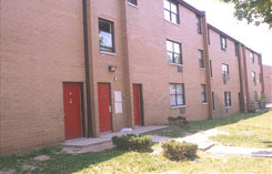

Presenting multiple images for the same idea would produce more accurate results. Both of the above photos are labeled “townhouses,” but the photo on the left depicting run-down buildings would be rated worse than the one on the right. This allowed participants to state their opinions based on actual conditions, not preconceived notions of what townhouses should look like.
Here are a few of the survey’s findings:
- The lowest ratings went to current conditions in Downtown Wheaton: jaywalkers (-7), run-down buildings along Triangle Lane (-7), businesses facing away from the street (-8), messy commercial uses (-8) and the lack of sidewalks along Georgia Avenue (-9).
- Among the highest ratings were a proposed amphitheatre (+6), live-work buildings (+6), more parks and plazas (+7), street landscaping (+7) and pedestrian refuges on wide streets (+8).
- While surface parking lots received low ratings (-7 and -8), a proposal to turn Parking Lot 13 at Reedie Drive and Triangle Lane into a plaza was coolly received, only getting a +4.
- Photos of modernist buildings were rated lower than those of traditional buildings, but newer buildings were preferred to older buildings.
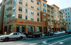
- Retail chains were received poorly. An image of an apartment building with a McDonald’s on the first floor received a lower score than one with other stores.
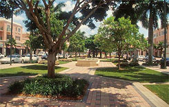
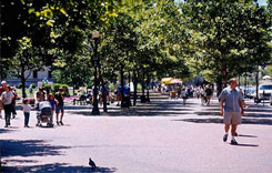
- Photos of empty parks were preferred over photos of parks with people in them, and urban parks with more pavement were rated more poorly than parks with trees and grass.
One conclusion that we can draw from the survey is that while stakeholders enjoy Wheaton’s diverse population and small businesses, they don’t like the way Downtown looks today. But what those improvements should be, and how they can be implemented, are unclear.
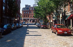
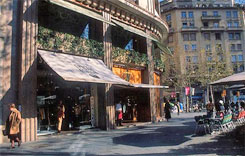
Images depicting what I might call “vacation urbanism” — the cobblestone streets and sidewalk cafes you might see on a trip to Paris — were rated well, suggesting Wheaton residents do like some things about the city. But the things that help make it work, like onstreet parking that buffers sidewalks from car traffic (not to mention can provide close-at-hand parking for disabled patrons) were largely rejected.
Photos of two- and three-story buildings received higher ratings (+5) than those of fourteen-story buildings (+2). This is a major issue considering that the Wheaton CBD Sector Plan could raise building heights to 200 feet and a 14-story building has already been proposed at Georgia Avenue and Reedie Drive.
Given that most of Downtown consists of low-rise buildings, continuing that development pattern might be very attractive to existing residents. Wheaton’s lucky to have an older building stock that makes it affordable for both residents and businesses. But its spread-out nature encourages driving, contributes to traffic, and has made it hard for reinvestment to occur.
Taller buildings and higher-density development could put thousands of new residents and office workers within walking distance of Downtown’s amenities. It would help provide foot traffic for local stores, keeping even mom-and-pops in business, and increase transit ridership. But it may erode the sense of “community” that comes from a smaller population.