Low-cost, short-term strategies for boosting Metrorail ridership

WMATA 7000 series train leaving Arlington Cemetery by PYZC used with permission.
This is part 10 in a series about how DC can achieve its Vision Zero and climate goals, with parts 7 - 10 highlighting the role of our regional transit rail system, Metrorail, in achieving those goals.
Doubling Metrorail’s pre-pandemic ridership to one million daily trips is necessary for the District to achieve its climate and Vision Zero goals. My previous posts have highlighted how reliable, high-frequency service from the system we already have is the top short-term priority and focused on the need to attract new riders by expanding the system’s physical footprint.
New lines and stations are exciting to dream about. They are also expensive and politically difficult. Expansive new coverage won’t get the District to carbon neutrality and zero traffic deaths anytime soon. But, if bringing Metrorail to new people is hard, bringing new people to Metrorail is relatively easy. We can and should plan for long-term expansion of the system while implementing low-to-medium-cost interventions to drive meaningful increases in ridership right now.
TOD you so
Since people generally conceptualize the length of a trip by how long it takes them to get from door to door, reducing the time it takes to get to or from a Metro station is as important as speeding up the Metro trip itself. Riders strongly prefer single-mode trips, so eliminating the need for them to use a second mode to get to a station also makes a big difference; one study has suggested this “transfer penalty” is equivalent to about 15 to 17 minutes of in-vehicle trip time, meaning that riders will take a trip that’s 15-17 minutes longer if doing so means they don’t have to change modes. Making it easier and faster to get to Metrorail stations, and reducing the need to change modes, are the kind of improvements that put transit on par with the convenience of driving for more people.
And, the fastest possible trip to a Metro station is no trip. Building as much housing as possible immediately adjacent to stations, called transit-oriented development (TOD), is the single most effective way jurisdictions in the region can help drive more Metrorail ridership and increase our housing supply.
The DC region is actually a leader in TOD: Some of the country’s most famous examples are here, including “the Arlington miracle,” where higher-density development around Orange line stations helped drop Arlington County’s total traffic counts—not just the per-capita numbers—to 25-year lows despite tens of thousands of new residents moving there in the same period.
Transit-oriented development led Arlington County to see decreases in car traffic despite population growth. Source: Arlington County traffic study 
It’s not just Arlington: A 2014 study found that people living in transit-oriented developments in the Washington and Baltimore regions reduced their trips by car by 38%.
New rail and bus trips don’t just come from people who live on top of, or next to, stations. Metro-accessible employment, dining, retail and entertainment options provided by mixed-use TOD offer riders throughout the rest of the system more destinations they can reach without a car. This combination of incoming and outgoing trips is ridership superfood; as the below chart shows, Metrorail stations with “significant” TOD (more than 35,000 jobs and households in a quarter of a mile) have outpaced the system average for ridership growth.
Stations with TOD have outperformed systemwide ridership averages. Source: WMATA 
Allowing more housing around stations costs the public basically nothing. It actually makes money: New residents and businesses in higher-density buildings bring new tax dollars, generating revenue for local jurisdictions to improve city services and re-invest in transit. And, those new residents cost far less, in terms of per capita infrastructure costs, than those living in developments built on greenfield sprawl.
A 2011 analysis by WMATA found that “the land within a half-mile of Metrorail stations generate[s] $3.1 billion in property taxes per year” for local jurisdictions already. The NoMa-Gallaudet station alone has served as a catalyst for over $2 billion in development. Considering how under-developed so many Metrorail stations still are, the economic potential for the region on these sites is immense. In its 2020 report on single-family zoning, the District’s Office of Planning showed how many of the District’s transit-accessible lots (½-mile from a Metrorail station or ¼-mile from a priority bus corridor) are zoned for low-density. Even in a region known for its TOD, there’s considerable opportunity for more of it in the District, particularly along the ends of the Red Line.
Transit-accessible lots within single-family zones in the District. Source: Office of Planning’s “Single-Family Zoning in the District of Columbia” report. 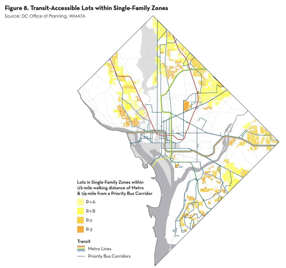
Likewise, there are many, many parking lots near Metrorail stations; DC alone has 1.67 square miles of surface parking lots within 1000 meters of a station. These lots represent the opportunity cost of all the residents and businesses that can and should be there instead and suppress ridership by making it far too easy to drive to a location that’s accessible by transit.
Parking lots adjacent to DC Metro stations. Map: Zach Ammerman, used with permission 
More specifically, the following is a non-exhaustive list of examples of stations that should anchor much denser, mixed-use development:
Tenleytown-AU is surrounded by an ocean of R-1B zoning, which allows only detached single-family housing on moderately sized lots (min 5,000 sq ft). While there is some retail next to the station, the Panera Bread and its neighbors at the east entrance in particular, are limited to two stories.
Low-rise commercial adjacent to the Tenleytown-AU station. Photo by the author. 
Fort Totten, where the Red and Green lines intersect, has even more TOD potential. The first map above, highlighting single-family-zone lots, doesn’t communicate the extent of the problem because the majority of land immediately adjacent to the station is open-space and industrial; it’s basically currently zoned no-density.
Fort Totten, a transfer station that connects the Red and Green lines, is surrounded by open space, industrial land, and low-density residential. Source: Google Maps 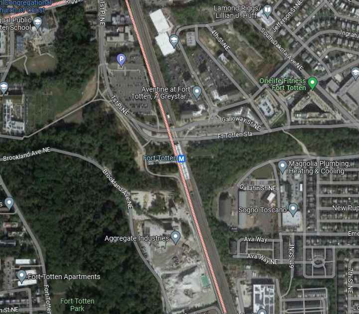
Metro Center, Gallery Place, Foggy Bottom, Farragut North and West—basically, all of downtown DC’s Metrorail stations are underused, even though downtown has some of the District’s highest-density zones. But because downtown is largely commercial property, there aren’t many full-time residents living close by. For instance, as the 2010 map from GGWash contributor D.W. Rowlands below shows, the census tract containing Metro Center and Gallery Place, the two most central stations in the entire system, had the same density range (7.5 to 15 people per acre) as the Tenleytown-AU station. As D.W. shows, densities of 15-30+ people per acre usually characterize high-transit areas.
2010 DC area population densities by Census tract with metro stations overlaid. Map: D.W. Rowlands, used with permission 
Converting those downtown commercial properties into apartments is a good and popular idea, but it has limited application: The District’s own task force on the matter found that “While the District does host millions of square feet of vacant office space, not all of it is a strong candidate for conversion to housing, let alone affordable housing,” that there are “numerous challenges and costs involved with the conversion from office-to-residential,” and that “given these realities, private owners might find it more profitable to let their office space remain vacant rather than undergo a conversion, even in a hot residential market like the District currently is experiencing.” One of those “numerous challenges” is the Height Act, an outdated mandate that is really only serving the aesthetic preferences of a narrow band of anti-growth activists.
WMATA, to its credit, has a plan for some of this. In April 2022, it released its first 10-year strategic plan for joint development. The plan selects 550 acres of land at 40 stations, system-wide, for joint development agreements that will boost ridership and increase WMATA’s lease revenues, in addition to generating new tax revenue in DC, Maryland, and Virginia. Last May, WMATA authorized solicitation for an initial seven of those 40 stations: Brookland, Capitol Heights, Congress Heights, Deanwood, Eisenhower Avenue, Fort Totten, and North Bethesda.
But WMATA is only one part of the equation. The agency and its development partners can only build where building is legally allowed and only up to the densities set by local zoning. The jurisdictions that control those land-use regulations can turn TOD in their areas from a nice boost to a transformational ridership and revenue plan with one easy trick: upzoning for residential uses. Industrially-zoned areas near Metro stations, such as Fort Totten, Rhode Island Avenue and Minnesota Avenue, need to be zoned light industrial/residential or commercial/residential. Anything that’s already mixed-use needs to make high-density legal by-right. Setback requirements and parking minimums need to be reduced or eliminated. And we need all jurisdictions to press the federal government to revisit or remove the Height Act. With every square foot within the quarter- to half-mile of stations at such a premium, as much of that acreage as possible should be put to the highest and best use of providing homes and businesses for people.
To take this all to eleven, WMATA and the region’s local governments should retain or acquire ownership of the land, allowing the public to capture any value gained by upzoning and turn the leases on that land into an even more powerful ongoing revenue source.
Catchment if you can
Putting residents close to Metro stations is very good, but the job is incomplete if those people can’t actually get to the stations themselves. WMATA planners have identified a ¼- to ½- mile “walkshed” radius around Metrorail stations, called a catchment area, as the distance that most people are willing to walk to a station. But the true walkshed depends on the quality and connectedness of the pedestrian infrastructure within that radius. Regular, even grids provide maximum access, while abbreviated and serpentine roads limit it.
Illustration of two different levels of walkability within the same radius. Source: Jarret Walker _1.png)
Walkshed comparison between Landover and Takoma Metrorail stations. Source: PlanitMetro 
Local streets are generally controlled by individual transportation departments; sometimes, Metrorail stations are adjacent to state-owned roads. The region’s jurisdictions could smooth this process by, if not wholly reworking their street grids, making sure at the least that their sidewalk networks are complete, in a state of good repair, and well-lit.
Metrorail stations graded by walkability. Source: PlanItMetro 
Some stations in particular are desperately in need of improvements that go beyond basic best practices, but are still within the purview of their local leaders. For example, the more than 1,200 households within a half-mile radius of the Southern Avenue station have no direct path to it: Residents have to walk to the eastern edge of their neighborhood and turn down Southern Avenue, the deadliest road in the District, for another quarter- to half-mile.
This map of the Southern Avenue Metro station demonstrates the limited “true” walkshed and the 1,200 households that could be added to it with a direct pedestrian path across Oxon Run Park. Source: PlanItMetro 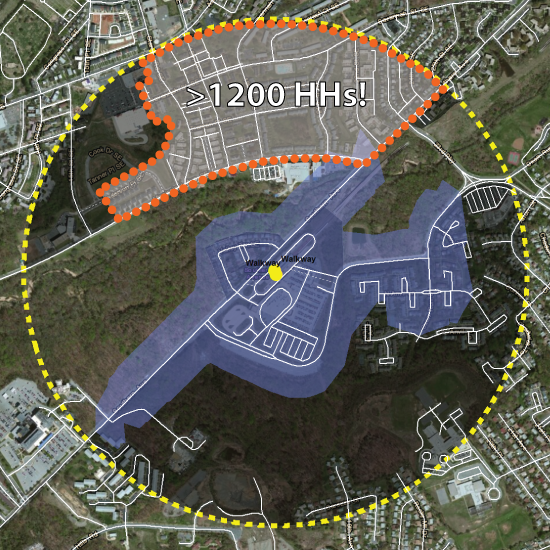
A direct pedestrian path through Oxon Run Park would cut down the time and risk inherent in reaching the Southern Avenue station, making it more attractive for at least a couple thousand people to ride Metro. (Frustratingly, WMATA planners identified this problem at least ten years ago but have not done anything to fix it.)
In some cases, particularly impassable obstacles or circuitous routes merit the even larger investment of an additional entrance. A good example is what’s planned for the NoMa station, which is functionally walled off by railroad tracks from the neighborhoods to its east—particularly the rapidly growing Union Market. Building a new east side entrance that tunnels under the tracks will extend the walkshed deeper into nearby neighborhoods and serve as a clear, visual invitation to those residents to choose Metro for more trips. NoMa’s new entrance is projected to cost $50 million dollars—expensive, but much more frugal than the $370 million price tag for Potomac Yard, the newest infill Metrorail station.
Rendering of proposed new entrance for the NoMa station. Source: NoMa BID 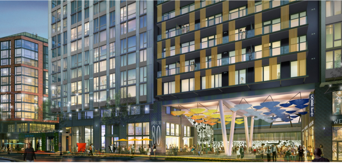
With some crowdsourcing help, I’ve compiled a list of other stations that could use new entrances to unlock new ridership. Some of these are already planned:
- North Bethesda, where the funded but delayed north entrance could cut the distance to Pike and Rose in half.
- Crystal City, where the also-already-planned new entrance will not only be closer to dozens of apartment buildings but will also simplify the transfer route between Metro and the Virginia Railway Express and Metroway bus stations.
- Forest Glen, where residents have long advocated for an entrance on the eastern side of Georgia Avenue that could make it easier to walk there from the Forest Estates neighborhood and other communities east of the station.
- Columbia Heights, where a southern entrance would put additional, notably dense, blocks of the neighborhood closer to its eponymous station.
- Mount Vernon Square, where a northern entrance would bring riders closer to O Street Market.
- Archives-Navy Memorial-Penn Quarter where a southern entrance at 7th and Constitution would add another station on the National Mall—for the tourists!
- L’Enfant Plaza, where a southern entrance and more direct walkways across I-395 to the Wharf could encourage fewer people to drive there.
Last-mile micromobility for macro ridership
There are even more potential riders beyond the best-practice, quarter- to half-mile walkshed. Making it easier for people to bike or scoot to Metrorail stations would also boost WMATA’s ridership. Faster and cheaper than funding new bus service, facilitating these longer “last-mile” connections expands a catchment area by reducing the amount of time the same trip would take on foot. A 2023 global literature review found that cycling in particular, can increase catchment areas by about two to five times in size.
The ability to leave a bike or scooter at the station instead of having to carry it on a train is a plus for riders. Sufficient, secure micromobility parking is necessary for someone’s personal bike or scooter, but Metrorail has benefited in particular from shared fleets. Trips on Capital Bikeshare and privately owned dockless bikes and scooters rose to a record high ~11 million last year in the District alone. Those trips have had a real impact on Metro ridership: A 2015 study of just Capital Bikeshare found that “a 10% increase in annual CaBi ridership contributed to a 2.8% increase in average daily Metrorail ridership.”
The upswing in available ebikes and scooters, which appeal to people who aren’t hardcore cyclists and enable longer or hillier trips, have driven the region’s micromobility boom. The slow, but steady improvement in the quantity and quality of bike lanes on our region’s streets is just as important as being able to easily find a device. Safety is the first priority in most riders’ minds, and most people aren’t comfortable riding in mixed traffic, or in unprotected lanes. Protected and/or separated lanes should be the minimum standard if jurisdictions want to assist Metrorail in making ridership gains.
If the quality and connectivity of the sidewalk network around a station determines the size of a walking catchment area; connected and protected bike lanes, and low-traffic, low-stress streets make up the true reach of a bike or scooter catchment area. If the region’s local governments are building bike lanes, or making changes to slow traffic, they should prioritize doing so in the immediate radii of Metrorail stations.
Building more transit-oriented developments and expanding catchment areas are short- and medium-term investments that don’t require as intensive planning as long-term capital projects like new stations or lines. Both WMATA and local jurisdictions can and should identify and accelerate these projects to kickstart a virtuous cycle of more riders, whose presence will increase demand and revenue for larger investments.