Where is Falls Church, exactly?
A couple months ago, Greater Greater Washington editor Dan Reed wrote about how Silver Spring doesn’t have actual boundaries. That’s not the only place in our region where that’s the case: the question of where, exactly, Falls Church’s borders are is also an open one.
Unlike Silver Spring, there is an official boundary in terms of the City of Falls Church (which is an independent city not part of Fairfax County):

Map of the City of Falls Church from Google Maps.
But when people say “Falls Church,” they have always meant more than the current boundaries of the city (in fact, neither the East Falls Church nor West Falls Church Metro stations are in the City of Falls Church). So, let’s start with a bit of history.
In 1875, Falls Church gained township status within Fairfax. In 1887, it retroceded “South Falls Church” back to Fairfax (I touched on this in a 2014 post about the naming of West Falls Church). According to the City’s website, “In 1890, the Town Council of Falls Church voted to cede its other majority African American districts to Fairfax County. As a result, over one-third of the land that made up the town was retroceded to the County.”
East Falls Church, which makes up the western corner of Arlington County, has its own interesting history. It was part of the Town of Falls Church (while simultaneously within a county, which changed designations as Virginia ceded its portion to, then retroceded it back from, the District of Columbia).
So, from 1875 to 1887, the Town of Falls Church included what is basically today’s City, along with South Falls Church and East Falls Church. I found a map of the Town of Falls Church here and georeferenced it onto a current map:
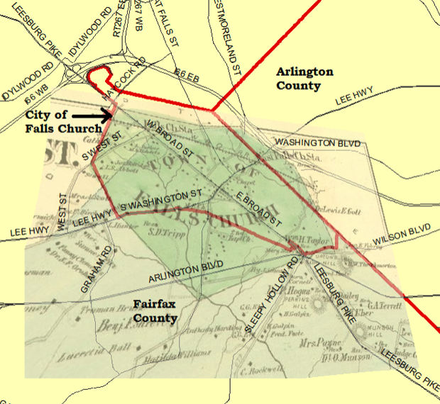
Current City of Falls Church boundaries are in red, overlaying a map of the former “Town of Falls Church.” Map by the author using data from Fairfax County GIS and Quora.
For a more modern look at what the boundaries of Falls Church could be, we can start with the most inclusive: postal addresses that use Falls Church. The peach-colored area in the map below represents the five zip codes that use Falls Church in their addresses. While it’s the largest area considered, it omits East Falls Church, which has an Arlington address.
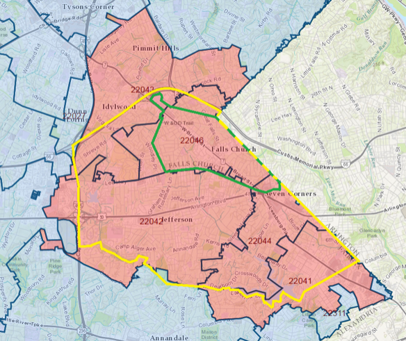
Map from Fairfax County GIS with annotations by the author.
On the other extreme, you could strictly define Falls Church as the City, whose boundaries are shown in green above. This is a tidy solution in that it is a formal boundary. But then what do you call the surrounding area?
(For those who are familiar with Falls Church but haven’t looked at these boundaries in a while, you’ll note the 22043 zip code sticking out. This reflects the the boundary of the City of Falls Church having changed very slightly in the last few years: the middle school and the high school for the City of Falls Church had been in Fairfax County (adjacent to the city boundary). As part of the deal where Fairfax Water bought the Falls Church City water system a few years ago, Fairfax County handed over the school property to the City.)
Could physical features define Falls Church?
In Dan Reed’s post about Silver Spring, and in the comments, there was mention of physical attributes (roads, natural features) as boundaries.
With this approach, I-66 (to the north), the Beltway (to the west) and Holmes Run/Columbia Pike (to the south) would be logical boundaries for Falls Church. This is shown in yellow above. (To the east, I selected the Arlington County border which, admittedly, isn’t a physical feature.)
I often hear the term “Greater Falls Church” to describe the City and surrounding areas, but I wasn’t able to find any formal boundary definitions of such. I checked the circulation information of the Falls Church News Press, which says it targets “…customers in the greater Falls Church area of Northern Virginia.” They deliver to the five zip codes above, but provided no additional information on their website. (Their circulation is quite sparse outside of the City.)
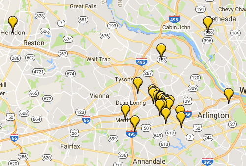
The Falls Church Chamber of Commerce, which used to be called the Greater Falls Church Chamber of Commerce, has a map of its members that corresponds closely to the northern half of the zip code area:
But other than the formal boundaries of the City, there are no formal definitions of where “Falls Church” begins and ends. So, what do you consider the boundaries of “Falls Church” to be?