Increasing heights is not a simple proposition in Ward 7
Photo by Carl_C on Flickr.
Ward 7 is one part of Washington where the federal Height Act is not the main limit on the ability to add density to the urban fabric. More relevant constraints are the community’s desire to preserve their neighborhoods’ qualities and the lack of land suitable for high-density development.
The Height Act bases maximum heights on the widths of adjacent streets, to a maximum of 110 feet at the largest streets except for 130 on Pennsylvania Avenue downtown. (It has nothing to do with the height of the Capitol Dome, contrary to popular belief).
Earlier this month, Housing Complex reported that Mayor Vince Gray wants to relax the height limits East of the River and discussed the legislative challenges to implementation.
But the Height Act isn’t the main driver of building height. In most parts of DC, zoning limits building heights far more than any federal law. Currently, the Marbury Plaza Complex is the only building in the Ward that even peers above the tree line, let alone approaches the federal limit.
Many long-time residents have expressed a desire to limit the height to 4-6 stories to preserve some of the best views in the city and the overall neighborhood harmony. ANC 7B, which includes the Hillcrest, Fort Davis, Penn-Branch, and Fairlawn neighborhoods, went as far as to pass a resolution to limit height at the Penn-Branch Shopping Center.
Putting the community concerns aside, there are other hurdles to denser development in the Ward. Although Ward 7 is one of the geographically larger wards, there are only a handful of areas that are even candidates for development into a higher density. Most of the land use in the ward is either single family homes, medium-density condos, neighborhood-scale commercial, or parkland owned by the National Park Service.
None of these areas are completely untouchable into the future. However, given the long time-frame to amass property from multiple owners or navigate the federal process to convert parkland into development, it is a safe bet that these areas will not become more intensively used within the next 20-30 years.
The next issue is that some of the larger low-density commercial areas ripe for redevelopment already have shovel-ready projects with maximum heights of 4-5 stories. For example, Mayor Gray’s proposal would not affect Skyland Shopping Center or the Minnesota-Benning project located next to the new 5-story Department of Employment Services building. It also probably wouldn’t affect the potential Walmart location in Capitol View located across the street from the Capitol Heights Metro Station.
After excluding all the previously mentioned areas as candidates for redevelopment into higher density, the only areas left are around the ward’s three Metro stations. Even transit-oriented development around them is a challenge.
The obscure location of the Deanwood Metro Station and odd shape of the potential development parcels around it, limit higher-density development. If the newly built Deanwood Recreation Center & Library and middle school are excluded, the only non-residential land left is a small sliver on the east side the metro station and an odd shaped industrial parcel on the west side of station. Even if the city made significant improvements to the road network to improve access, there is still the challenge of trying to put high density on small parcels.
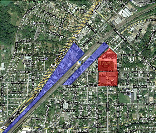
Deanwood Metro. Image from Google Maps. Click for interactive map.
Similar to Deanwood, Benning Road Metro Station abuts single family homes and is surrounded by oddly-shaped parcels. While Clarendon is an example of higher buildings next to low-density residential, the parcels around the that metro station aren’t as narrow as at Benning Road. There is potential for redevelopment into a higher density. The question for this metro station is whether the existing height limit is adequate given the size of the lots.
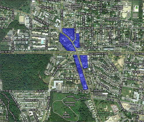
Benning Road Metro. Image from Google Maps. Click for interactive map.
Of all three Metro stations, the Minnesota Avenue seems like it is the only one that would even be a potential candidate for additional height over the Height Act limit. While the development projects there are already built or shovel-ready, the strip-mall commercial areas across Minnesota Ave SE and Benning Rd SE could be more densely built.
This commercial area sits in a valley with only a handful of single-family homes along Benning Road in this area. They would lose their panoramic views, but they would maintain some views of the city. The rest of the land in that area is Fort Mahan Park. One concern would be the buildings dwarfing the homes along Clay Place NE on both side of Minnesota Ave. Putting higher buildings closer to Benning Road and stepping down the height closer to the homes could resolve this issue.
The Minnesota Ave Metro Station is wedged between I-295 and Minnesota Ave. On the other side of I-295 is the PEPCO Plant. According to PEPCO, it will decommission the plant in the near future. There are a significant number of environmental issues associated with that property that need to be considered, but there are not insurmountable.
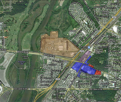
Minnesota Avenue Metro. Image from Google Maps. Click for interactive map.
Regardless of the potential for additional height, the community has expressed that it doesn’t want development at heights allowed under the Height Act. If Mayor Gray decides to move forward with this proposal, he will have to work very hard to move this through the legislative process while garnering the support of the community.