America’s main street should be car-free
One of the frequent events on Pennsylvania Avenue that opens the street to people. by National Capital Planning Commission.
This post is the sixth in an ongoing series about reducing the trips people take by car in DC. See the full series.
Residents of and visitors to the District must drive less if we are to meet our leaders’ safety and sustainability goals, to the tune of each person reducing their trips by car by about 25 percent.
As I’ve written in previous posts, this isn’t an impossible “ban cars” agenda. Instead, it’s a reasonable goal that public policy can and should help individuals achieve, because we can achieve meaningful safety without eliminating cars entirely from the District.
But we don’t have to accept them on every street. Making streets car-free is an exciting, tangible way to demonstrate that car access is not essential for desirable, thriving neighborhoods and to inspire people to leave the car at home more often.
F Street and 8th Street NW (facing southwest), featuring a short, and short-lived pedestrian mall. by DC Preservation League Photo Archive used with permission.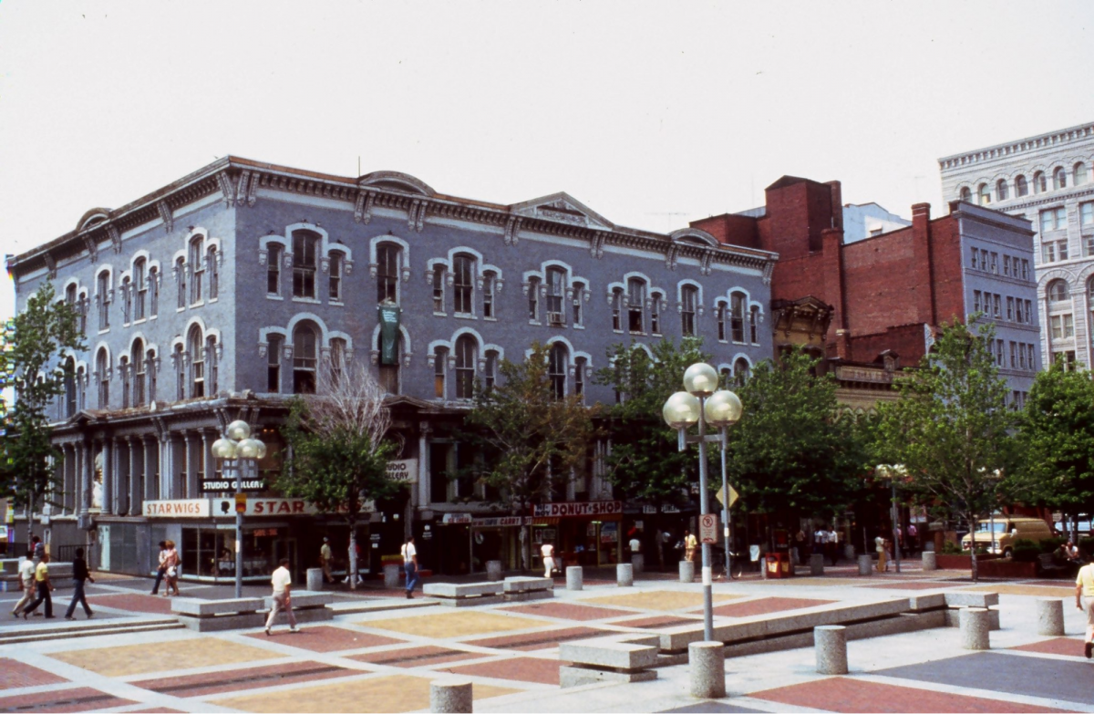
Not our first rodeo
Car-free zones, or pedestrian plazas, aren’t foreign to the District. In the 1970s, two blocks each of F and G streets downtown were closed to drivers. The effort was part of a nationwide trend to try to stem the tide of population and business loss from downtowns by copying the popular suburban shopping mall model.
Unfortunately, DC’s plazas suffered the same fate as most other American examples; the pedestrian malls lacked both enough businesses and customers to survive. By the late 90s, the District had reintroduced car traffic to both streets.
Today, the US features only a few surviving plazas from that era, including famous examples like Santa Monica’s Third Street Promenade, Miami’s Lincoln Road, Boulder’s Pearl Street, and Charlottesville’s Historic Downtown Mall, as well as less-well-known small-town examples like Winchester, Virginia and Cumberland, Maryland. They remain some of the most popular and iconic destinations of their respective cities.
Santa Monica’s 3rd Street Promenade, 2005. by Crashworks licensed under Creative Commons.
European cities experienced the same mid-century pedestrianization movement, but have generally expanded those efforts in the decades since. Notably, leaders of these cities have not just removed parking and travel lanes from additional streets or plazas, they’ve either connected those streets into contiguous car-free networks, or supplemented them with larger “limited traffic” zones. Such “car-lite” areas allow some vehicle access for public transit, residents, deliveries, and taxis, but restrict most others to enable lower-traffic, lower-stress streets that pedestrians and cyclists can more easily share.
Las Ramblas in Barcelona. Image by the author. 
For comprehensive examples, see Copenhagen and Vienna’s pedestrianized street networks, Ljubljana’s city center, Milan’s Area C, Ghent’s Circulation Plan, Florence’s historic core, Brussels’ Pentagon, and Madrid’s 360 plan.
For inspiring visuals of individual transformations both big and small, see these streets in Berlin, Paris, Rotterdam, Bruges, Groningen, Barcelona, Dusseldorf, Cordoba, Amsterdam, Brussels, Innsbruck, Mexico City, Haarlem, Toulouse, Montreal, and Seoul.
Florence’s 2011 expansion of its pedestrian zones. Pink areas were the existing pedestrian-only zones, blue sections the new additions, and yellow streets the limited traffic areas open only to public transit and taxis under certain conditions. Image by Marco Giannini used with permission.
These pedestrian and low-traffic zones have been successful in reducing pollution, increasing biking and walking, reducing traffic violence, generating economic activity, and engendering popular support.
Bring it home
Where could DC pilot its own car-free zones? This is a question GGWash contributors have pondered for over a decade. Dozens of streets should be candidates. Present-day foot-traffic hotbeds like 7th Street in Gallery Place, M Street in Georgetown, and 18th Street in Adams Morgan top my list, though the so-far-unsuccessful attempt to literally just do this on the latter shows the political and bureaucratic obstacles the District has put in front of itself here. Likewise, the most notable “pedestrianization” in recent years was the short-lived Black Lives Matter plaza experiment. The ultimate decision to confine pedestrians to an amenity-less narrow strip in the middle of the street to preserve driver access only illustrates the problem further.
The most symbolic street I’d choose, however, is Pennsylvania Avenue NW. The 1.2-mile stretch, dubbed “America’s Main Street” for its monumental vistas and ceremonial importance in connecting the Capitol and the White House, already boots cars quadrennially for presidential inaugurations. But outside of special events, the space is overbuilt, underwhelming, and frequently hostile.
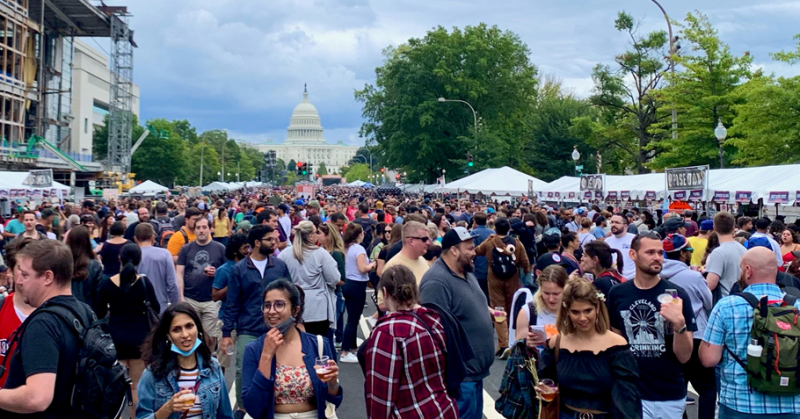
DC Capital Pride festival on Pennsylvania Avenue NW and Constitution Avenue NW looking west by Tim Evanston licensed under Creative Commons._800_530_90.jpeg)
Here’s why closing Pennsylvania Avenue NW to cars just makes sense:
- It doesn’t even go anywhere!
Unlike most arterials in DC, Pennsylvania Avenue NW doesn’t carry significant through-traffic. It dead-ends on each side! For those concerned about traffic flow anyway, every spot along it is within about a block of the parallel E Street NW or the eight-lane Constitution Avenue. Most potential street redesigns of this size and scale would require conversations about making driving (slightly) less convenient , but Pennsylvania Avenue NW is uniquely unburdened already!
- It’s already closed to cars…sometimes
According to the National Capital Planning Commission (NCPC), Pennsylvania Avenue NW already hosts over 150 events per year. The largest close the street to vehicles and attract thousands of people to eat, drink, watch performances, or simply enjoy the whole scene. Permanently closing it to cars could attract even more events and make expanded patio dining, street vendors and ad hoc performances evergreen attractions.
- It should be marquee destination
Without even counting the Capitol and White House, Pennsylvania Avenue is filled with cultural attractions: museums, memorials, theaters, and parks, plus a new university campus and some of the city’s signature hotels. And the pending departure of the FBI from the Hoover building will present the opportunity to wholly redesign a full block.
While all of the above are just a little too spread out to rival the density of retail and nearby residential that characterize the best domestic and international pedestrian streets, DC’s steady stream of tourists provides a meaningful substitute. The adjacent National Mall attracts 25 million people a year to similar sites with no supporting commercial amenities
Implementing car-free conditions on Pennsylvania Avenue NW would create one nearly seamless pedestrian experience with the Mall, with complementary uses. Visitors who currently drive or ride the bus in for the museums only might be encouraged to extend their visit for the stress-free shopping, dining and further exploration of Pennsylvania Avenue. And that increased foot traffic could help start a virtuous circle to bring more commercial, entertainment and hotels.
For a street with so much social importance, the status quo is a massive missed opportunity. Changing this street so that people actually want to be on it should be an obvious desire.
Mayor Muriel Bowser began her third term with a big pitch to revitalize downtown. Making Pennsylvania Avenue a place where people want to spend time and money is probably a better strategy than begging the President to squeeze the remote-work toothpaste back into the tube.
Pedestrianizing Pennsylvania Avenue would restore it to its past glory. by HandlebarsDC, photo taken of a photograph in the interior of the Old Post Office Building.
Plans in motion
Pennsylvania Avenue NW isn’t governed by the District alone. Because it’s within the federal core, the corridor is also controlled by the National Capital Planning Commission, a federal planning agency.
But NCPC is on it. It released an initial report of its Pennsylvania Avenue Initiative to redesign the street in 2017, and in 2022, revealed three proposed concepts. All three would move Pennsylvania Avenue NW in the right direction of prioritizing people over cars, though all have major shortcomings.
Via its Pennsylvania Avenue Initiative, NCPC has proposed three concepts for a redesign. by National Capital Planning Commission.
Concept 1, “Urban Capital,” is most similar to the status quo, and therefore the most uninspired. While reinvigorated sidewalk space is nice, preserving four car-travel lanes ensures that Pennsylvania Avenue NW will remain as-is for the next several decades.
The Pennsylvania Avenue Initiative’s Concept 1,“Urban Capital” preserves four car lanes. by National Capital Planning Commission.
Concepts 2 and 3 (“Linear Green” and “Civic Stage,” respectively) are much better. By eliminating car-travel lanes completely, Concept 2 most fully embraces the power of car-free streets to welcome pedestrian life without the backdrop of life-threatening risk. Concept 3, on the other hand, physically and symbolically centers the human experience (not to mention the monumental views) more than the others, with its center-running pedestrian promenade.
Concept 2, “Living Green.” by National Capital Planning Commission. Concept 3, “Civic Stage.” by National Capital Planning Commission.

Don’t settle for good enough
Here’s how I’d turn these genuinely exciting concepts from good to great:
1. Propose a “Concept 2.5,” featuring the central pedestrian promenade of Concept 3 while incorporating the complete removal of car lanes found in Concept 2.
2. Assess rerouting Metrobus routes. With the heavy caveat that I am not a bus planner, Constitution Avenue is not even a full block away from most of the street and is already a bus route. If the 14th and Pennsylvania stop could be moved to 15th, that would make relocation of the 12th Street stop the largest change. A stop at 12th and Constitution would be ~325 meters away from 12th and Pennsylvania. This would add a couple of minutes walking time for riders going to destinations north of Pennsylvania, but provide equivalent reduction for any heading south. Because of the diagonal, relocating the stop further east at the National Archives, however, would be half that distance. While moving any bus stop is a significant decision deserving of real study, a true overhaul of Pennsylvania Avenue would at least consider whether going from “occasional buses” to “no vehicle threats at all” is worth pursuing.
Pennsylvania serves a small portion of the 32, 33, 36 and P6 bus routes. by WMATA.
Potential rerouting of Pennsylvania Avenue bus routes and stops showing present-day locations in red and potential new route and stops (aligned with existing ones on Constitution) in purple. Image by the author. 
3. Direct north-south vehicle traffic to select streets. Concepts 2 and 3 would both improve the pedestrian experience within each block, but leave people hanging at cross-streets. If drivers were routed onto some, but not all, cross-streets (3rd, 15th…7th, if we must…), there would be a more seamless plaza experience up and down Pennsylvania Avenue NW, up to and including planned revitalizations of the under-utilized Pershing Park and Freedom Plaza. (Ideally, any changes to the latter would preserve the vibrant skating community that has kept the space from being a complete deadzone and invite others to use it as well).
NCPC’s concepts still retain vehicle traffic on almost every cross street, restricting the transformative power of these plans to create public space more heavily to just three specific, disconnected areas. by National Capital Planning Commission.
The difference between “fewer vehicles” and “no vehicles” is vast. A complete absence of cars, drivers, and the lanes they require for traveling and parking unlocks the kind of stress-free pedestrian experience that can make a space positively memorable. Vendors could set up in all areas of the street, with shoppers flitting back and forth between stalls and the brick-and-mortar retail along the periphery. Restaurants could offer expansive patio dining without asking diners or servers to dart across traffic. Parents could let go of their childrens’ hands to play—just like at a park.
There’s room in two out of three of NCPC’s concepts for a truly transformative vision for Pennsylvania Avenue NW. The next phase of their project is procurement for an interdisciplinary consultant team to prepare a new plan incorporating feedback on the concepts NCPC has received. If you like what I’m saying here, you can echo it in your own comments to info@ncpc.gov.
Pedestrianizing one street won’t on its own elicit changes in District-wide travel patterns. And District residents deserve car-free streets in the neighborhoods they live in, not just in our tourist-trod downtown. But as a symbolic embrace of the concept of car-free spaces that could help inspire and set the tone for wider implementation, Pennsylvania Avenue really does offer an unparalleled opportunity. The existing plans are already knocking on the door. Let’s aim big and deliver District residents and visitors a world-class space befitting our world-class city.