Here’s how neighborhoods west of Kenilworth Avenue in Northeast DC became isolated from the city
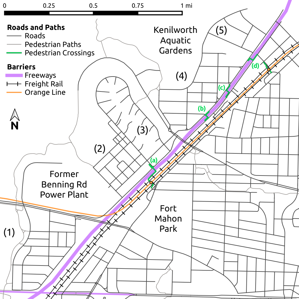
A present-day map of neighborhoods in Northeast DC isolated by Route 295 and railroad tracks: (1) River Terrace, (2) Parkside, (3) Mayfair, (4) Eastland Gardens, and (5) Kenilworth. The four pedestrian bridges over Route 295 and associated Metrorail underpasses are shown as well: (a) the Parkside pedestrian bridge and Minnesota Avenue station underpass, (b) the Lane Place pedestrian bridge, (c) the Nash Street pedestrian bridge, and (d) the Douglas Street pedestrian bridge and Deanwood station underpass.
This article was first published on July 22, 2021. We love investigating how neighborhoods in the region have changed over the years and wanted to share this piece with you again.
As I discussed in a previous article, the neighborhoods of River Terrace, Parkside, Mayfair, Eastland Gardens, and Kenilworth in Northeast DC are isolated from the rest of the District by the Anacostia River to the northwest and DC Route 295 to the southeast. While these neighborhoods are very isolated and contain some of the lowest-income Census block groups in the District today, they were sited to take advantage of direct transportation routes to downtown and built for higher-income professionals.
19th-century origins
The road that became Kenilworth Avenue, and then the Kenilworth Avenue Freeway portion of DC Route 295 had its beginnings in the mid-18th Century, as Eastern Branch Road, connecting a ferry across the Potomac at Alexandria to the port town of Bladensburg, which was founded in 1742 at the head of navigation on the Anacostia, which was then known as the “Eastern Branch of the Potomac.”
The importance of the road increased with the construction of the federal capital in Washington in the 1790’s and, in 1805, a landowner named William Benning built a toll bridge across the Anacostia to connect his land on the eastern bank to the City of Washington on the western bank of the river.
From Benning’s bridge, the road that became present-day Benning Road crossed Eastern Branch Road and continued southeast as Marlboro Pike, connecting Washington to the Prince George’s county seat in Upper Marlboro. Until the East Capitol Street Bridge and the New York Avenue Bridge were built in the mid-1950’s, Benning Road was the only road to cross the roughly four-mile stretch of the Anacostia between Pennsylvania Avenue and Bladensburg, making it an important artery for traffic entering Washington from the east.
An 1878 map of the eastern bank of the Anacostia, from what is now East Capitol Street to the DC border. The road marked "Marlboro Road" is today's Sheriff Road. Image by Library of Congress of page from the 1878 Hopkins Atlas of Fifteen Miles Around Washington.
While the eastern side of the Anacostia remained largely rural until the end of the 19th Century, a small village seems to have developed by the 1870’s where Benning Road crossed the old Eastern Branch Road, now called Anacostia Road in keeping with the newer name for the river. In 1870, the Baltimore & Potomac Railroad, a subsidiary of the Pennsylvania Railroad, built what is now the CSX Landover Subdivision as its original entrance to the District. In 1874, the Baltimore & Potomac tracks were joined by the B&O Railroad’s Alexandria Extension, which followed the same route along the Anacostia and continued to Shepherd Point, where a ferry linked it to Alexandria.
This 1891 map of the eastern bank of the Anacostia from Benning Road to the DC border shows property lines and that an early suburban subdivision has begun to be built north of Benning Road and east of the railroad tracks. Anacostia Road now divides into two branches north of Benning Road: one remaining to the west of the railroad tracks and connecting to Washington via the Benning Road Bridge, and its original route, crossing the tracks and continuing south as what is today Minnesota Avenue. Image by Library of Congress of the 1891 Hopkins Map of the District of Columbia.
These rail lines entered the District along the east side of Anacostia Road and crossed to the west of it very near the location of today’s Minnesota Avenue metro station. A rail station at this point soon served the Benning Race Track, which also opened in the 1870’s, and the rail crossing seems to have led to a bifurcation of the Anacostia Road. The old route, crossing the rail tracks and continuing south toward Alexandria became today’s Minnesota Avenue, while a new branch, which became part of today’s Kenilworth Avenue, continued on the west side of the tracks to Benning Road, allowing travelers from the north to cross the bridge into Washington without having to cross the railroad tracks twice.
The electric streetcar and Kenilworth
The electrification of the District’s streetcar network in the 1890’s made it possible for streetcar lines to extend substantially further from the city’s core than was possible for the slower horse-pulled and more expensive to build and operate cable-pulled streetcars that had operated in Washington and Georgetown for decades. As a result, streetcar lines began to extend into the formerly-rural portions of the District, where farmland was rapidly subdivided into new suburbs.
In 1898, the streetcar line that had run along H Street NE since 1871 was extended across the Benning Road bridge and then north along Anacostia Road to the Benning Race Track, where it crossed the railroad tracks and ran east to Seat Pleasant along a private right-of-way that became today’s Nannie Helen Borroughs Avenue. This route, which from 1908 to 1935 also hosted the Washington, Baltimore, & Annapolis Electric Railway’s interurban streetcars from Baltimore, served a number of subdivisions that were soon built along the Nannie Helen Burroughs Avenue portion of the route. However, the swampy land along the Anacostia south of the Benning Race Track and adjacent to the Benning Road Power Plant, which opened in 1906, was initially unattractive to developers.
This 1907 map of the eastern bank of the Anacostia between East Capitol Street and the District border shows the beginning of the Kenilworth subdivision just southwest of the border, as well as a number of suburban subdivisions on the east side of what is now DC-295. Roads shown as dotted lines have been proposed but not actually built, and some were never built. Image by Library of Congress of the index map of Baist’s 1907 real estate atlas of the District of Columbia.
However, in 1895, the real estate developer Allen Mallery bought and subdivided a tract of land along Anacostia Road and what is now Olive Street NE near what is now the Deanwood Metro station as a suburb he named Kenilworth after the Sir Walter Scott novel Kenilworth, set at a castle of the same name in Warwickshire, England. The subdivision was intended to be a community for upper-class white suburbanites and, in 1898, Mallery paid for a branch of the Benning Road streetcar to be extended to the DC border along the portion of the Anacostia Road that he renamed Kenilworth Avenue.
In 1898, Mallery purchased and subdivided an additional tract of land northwest of Kenilworth Avenue, which became Ord Street NE. Soon afterward, in 1903, a Black neighborhood independently developed, along the road—now Douglas Street NE—leading to the privately-owned lily farm that eventually became today’s Kenilworth Aquatic Gardens. Further development west of Kenilworth Avenue stalled, however, due to the area’s swampiness and its proximity to the Benning Race Track, which remained a popular site for gambling and horse races until Congress banned them in 1908. (Car racing and training races for race horses kept the track operating in some capacity into the 1930’s.)
Black professionals settle west of Kenilworth Avenue
While flooding, the race track, and proximity to the power plant helped to keep the area that is now Eastland Gardens from being developed for several decades, undeveloped land along a streetcar line eventually proved appealing to higher-income Black Washingtonians who were excluded from most new suburban developments by restrictive covenants. In 1927, developers purchased the land between Ord Street NE and the Benning Race Track and hired Black architects — including Lewis Giles, Sr, J. Alonzo Plater, and Romulus Archer — to design and Black-owned construction companies to build single-family detached houses for Black professionals.
A map of the stretch of Kenilworth Avenue between Benning Road and Eastern Avenue in 1929, just as Eastland Gardens was being subdivided. Building locations are based on a 1927 areal survey, and paved roads are marked in red. Image by Library of Congress of 1929 USGS map of Washington and Vicinity.
Once the race track was finally abandoned some time in the 1930’s, it was quickly replaced with more housing: the Black broadcast evangelism pioneer Elder Lightfoot Soloman Michaux purchased the site and built the Mayfair Mansions apartment complex between 1942 and 1946. The garden apartments surrounding a central courtyard, which are today largely subsidized affordable housing, were designed by the prominent Black architect Albert Cassel and were originally marketed as a fashionable address for young Black professionals who were not yet ready to purchase their own homes.
Not everyone who moved into the area between the Anacostia and the railroad tracks in the 1930’s and 1940’s was Black, however. In 1937, construction began on the rowhouse neighborhood of River Terrace on the south side of Benning Road, where restrictive covenants only permitted white residents. The developers of River Terrace marketed the houses to working-class whites, and advertised it as “eight minutes from downtown Washington, with street cars and buses close at hand,” less than half the time it takes the X2 bus to traverse the same route today.
During World War II, the District’s population surged to an all-time maximum at the same time as the federal Alley Dwelling Authority was demolishing the alley-fronting apartments where many Washingtonians lived. As part of the response to the resulting housing crisis, the Alley Dwelling Authority funded the 1943-1944 construction of the Lily Ponds Houses public housing complex for white war workers on an extension of Quarles Street west of Kenilworth Avenue.
White Flight and the freeway
As seen in the 1937 Federal Housing Administration map below, distance from downtown and nearby industrial uses depressed housing prices in the Kenilworth Avenue corridor. While rents in the Black neighborhoods of Eastland Gardens and Douglas Street were cheaper than in the white developments of Kenilworth and River Terrace, the range of rents in the area was consistently significantly lower below what was found in most neighborhoods west of the river, or even in Anacostia and Fairlawn, which were more convenient to downtown jobs and further from the Benning Road power plant.
This map from 1937 shows rental prices for housing by block in the Kenilworth Avenue area. Blocks in this area fall into the three cheapest categories: Yellow for less than $20/month, orange for $20-30/month, and light blue for $30-40/month. Image by Library of Congress image of 1937 Federal Housing Administration map of Washington, DC.
In addition, the area became more industrial in the 1940’s, especially after the Kenilworth Dump opened in 1942 on the site that is now Kenilworth Park, between the Anacostia and the Mayfair Mansions apartments. Garbage was burned at the dump on a daily basis, and by the 1960’s, a quarter of a million tons of waste were burned in the open annually. Furthermore, in 1949, streetcar service across the Benning Road bridge was replaced with buses, reducing the draw of the area to families who increasingly commuted by car.
By the early 1950’s, most of the white families in Kenilworth had moved to further-out suburbs and, in 1953, the District converted the Kenilworth Elementary School from a whites-only to a Blacks-only school. The whites-only Lily Pond Houses were also demolished in the early or mid-1950’s, converting the area west of the railroad tracks and north of Benning Road into an entirely Black enclave. White flight took longer to take hold in River Terrace—when the first Black family moved into the neighborhood in 1951, they were met with Ku Klux Klan cross burnings. However, by the mid 1950’s, that neighborhood had begun to transition as well.
This 1947 USGS map shows the Kenilworth Avenue corridor a few years before the decision to convert Kenilworth Avenue into a freeway. However, the Mayfair Mansions apartments and the Kenilworth Dump appear to be missing. Image by Library of Congress of 1947 USGS map of Washington and Vicinity.
It is noteworthy that the conversion of Kenilworth Avenue into a freeway was first proposed in 1950, just as the neighborhoods that would be most cut-off by the freeway were in the process of becoming entirely Black. When construction began in 1954, thirty-five houses in Kenilworth and Eastland Gardens were demolished, along with the stores along Kenilworth Avenue that had provided local retail to the communities, the Kenilworth Community Center and the newly-rebuilt Kenilworth Presbyterian Church. Furthermore, the Washington Post reported that the owners of the remaining businesses complained that the construction of the freeway cost them substantial business from drivers entering and leaving DC along the corridor.
Even after the freeway was completed, the construction of new housing west of it continued. The present-day Kenilworth Courts public housing complex—one of the country’s first to be racially integrated—was built in 1959 on the site of the demolished Lily Pond Houses and, in 1964 Elder Solomon Lightfoot Michaux built the Paradise Manor apartment complex to the northwest of Mayfair Mansions on the remainder of the old Benning Race Track site.
Activism and the Orange Line
While the construction of the Kenilworth Dump and conversion of Kenilworth Avenue seem to have signaled a decision by the District government, which was still Federally-appointed, to treat the predominantly-Black areas between the Anacostia and the railroad tracks as an environmental sacrifice zone, activism in these communities pushed for improvements. Public pressure finally led to the end of open burning at dump after seven-year-old Kelvin Mock was caught in the flames and burned to death in 1968. Although the site continued as a sanitary landfill for several years, by the mid-1970’s, it had been converted to a park and the Kenilworth-Parkside Recreation Center opened. However, remediation of part of the contaminated area is still not complete half a century later.
Additionally, in the 1970’s and 1980’s, the Kenilworth Courts public housing complex became a leader in tenant-management of public housing, which led to improved maintenance and public works on the site. Residents of the complex also lobbied for a north entrance for the Deanwood Metro station to serve their community. The future of the Kenilworth Courts community is less certain, however, as the complex is being demolished and replaced with mixed-income housing.
While the 1978 opening of the Orange Line’s Minnesota Avenue and Deanwood stations provided a faster commute downtown for residents of communities on both sides of Route 295, the construction of the Metro line also reduced connectivity between the neighborhoods on the western and eastern sides of the highway. When Kenilworth Road was converted to a freeway in the 1950’s, only three road crossings of it in the District were retained: bridges over the freeway at Benning Road and Eastern Avenue and an underpass at Deane Avenue. However, a number of pedestrian overpasses were also constructed to allow local residents to cross the road to reach neighborhoods—and stops on the Kenilworth Avenue bus line, which ran via the freeway service roads to Benning Road and downtown—on the opposite side.
Unlike the road crossings, however, these pedestrian underpasses did not cross the Landover Subdivision and Alexandria Extension railroad tracks, which pedestrians had been crossing at-grade since the beginning of the Kenilworth subdivision over fifty years earlier. However, when the Orange Line was built between the two freight rail lines, it was fenced off to prevent electrocution from the electrified third rails, ending pedestrian crossings of the tracks. While two of the pedestrian bridges now feed into the Minnesota Avenue and Deanwood Metro stations, allowing pedestrians to cross both the freeway and the train tracks, the two bridges over the nearly-a-mile section of the freeway between the stations are now essentially dead ends.
Acknowledgments
The author would like to thank Justin Lini for valuable context about the Lane Place bridge and the surrounding neighborhoods, Libby Solomon and David Cranor for useful historical information about the Route 295 pedestrian bridges, and Tracy Lini for substantial help with the cartographic design of the maps in this article.
Note: This article is the second in a two-part series on the neighborhoods between the Anacostia and DC Route 295 in Northeast DC. The first article discussed these neighborhoods’ present-day demographics and transportation difficulties.