Why the Green Line in northern Prince George’s is a huge missed opportunity
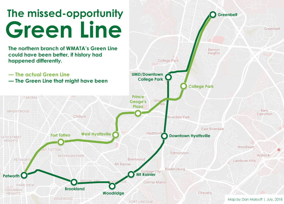
The Green Line that could have been. Image by the author.
This article was first pubished on July 24, 2018. As we navigate a pandemic and the future of Metro’s budget, we thought we’d look back and imagine the Green Line that could have been.
Imagine a Green Line that went from Petworth to Brookland, then on to Woodridge, Mount Rainier, Downtown Hyattsville, Downtown College Park, and finally Greenbelt. That would have been close to the same mileage as the Green Line that was actually built, but it would have replaced three primarily car-oriented Metro stations with four stations in walkable, transit-oriented places.
Had the Green Line been built along this alternate more urban alignment, it’s easy to imagine a vastly different northern Prince George’s County.
This alignment would have brought rapid transit closer to the heart of the communities it serves, putting more riders in reach of trains both in the 20th Century and today. In so doing, it would have generated more Metro rides, and reduced the number of car trips in the area. It would have added the University of Maryland and four walkable neighborhoods (including Woodridge DC) to the frustratingly short list of Metro-accessible walkable places in our region, supporting transit-oriented development in all of them, and in so-doing helping to off-set the housing shortage in such places.
Instead of tall buildings clustering around Prince George’s Plaza mall or stringing along Route 1, they might cluster in downtown Hyattsville or downtown College Park. The shopping and dining strips in Mount Ranier and Woodridge might have as many options as, say, Petworth. And it might all have happened sooner—these neighborhoods are hot today, but they might have attracted development earlier, perhaps as early as Silver Spring.
The downtown Hyattsville that might have been. Original image by Dan Reed, skyline image by Dan Malouff. 
And instead of a Green-to-Red transfer at isolated Fort Totten, the transfer station might have been Brookland, with its universities and inviting main streets.
It would be a big change, but a tremendously positive one for the region. With a less severe shortage of Metro-anchored walkable neighborhoods, and with more urban development having happened sooner, urban housing would be less scarce and thus more affordable across the entire region (though housing around these particular stations would likely be more expensive than it is today).
With more desirable station areas, this Green Line might even have helped offset the region’s so-called “east-west divide,” in which most of the region’s jobs locate to the west, leaving the east with less equitable access to work, longer commutes, and less tax revenue.
We might have a less segregated, more equitable, more environmentally sustainable region.
Why didn’t this better alignment happen?
Broadly speaking, mid-Twentieth Century planners weren’t thinking about transit-oriented development or supporting walkable neighborhoods, and they couldn’t have predicted 2018’s housing shortage. They were thinking about getting suburban commuters into downtown DC, via car-oriented park-and-rides. The absence of a station in Georgetown is another example of the same mindset.
Of course Arlington avoided this mistake with its Orange and Blue Lines, and Montgomery County fared better with Red. But those are rather incredible exceptions to the planning standards of the day. It’s remarkable that our region has as much transit-oriented development as it does. Metrorail’s contempories, San Francisco’s BART and Atlanta’s MARTA, are both much more park-and-ride oriented than WMATA, reflecting the trends of their time.
Specifically, Prince George’s County planners looked for stations that could affordably support large park-and-rides, and they hoped to support economic development mainly around shopping malls, most importantly Prince George’s Plaza. At the time in Montgomery County, even Silver Spring was struggling against the rising tide of Wheaton Plaza mall.
Even so, early proposals would have put some of the Green Line’s stations in better locations. Prince George’s Plaza station nearly went on Belcrest Road, closer to what’s now University Town Center. And College Park station nearly went directly onto the UMD campus, until neighborhood and university leaders fearful of racial intergration with Washington pushed for a less-useful station further from the center of activity, and won.
1973 plans showing Metro stations on Belcrest Road and on the UMD campus. Image by MDOT.
At the same time, planners were also working under the assumption that I-95 would extend from the Beltway into the District of Columbia. Some early station-siting decisions were based on that. West Hyattsville, for example, was originally intended to be in the median of I-95.
An urban subway would have been more expensive
Furthermore, the more urban alignment in this post would have been more expensive than what was built.
From Petworth to Greenbelt, the actual Green Line is 9.4 miles long, five miles of which are in a subway. The new Green Line described in this post would be 10.1 miles long, 7.6 miles of which would be subway. That equates to about 7% longer overall, and about 50% more tunneling, including multiple additional underground stations, and one entirely new station (stations being by far the most expensive part of Metro construction).
That alone could have sunk the idea.
But still, if the region had it to do over again, we’d probably want to spend the money on something like this alignment. And we’d probably have a station in Georgetown, and maybe Fairfax County would have routed the Orange Line in a subway under Route 29, and who knows what else.
If wishes were horses, beggers would ride. Obviously we’re not rebuilding Metro Lines in different locations now, nor should we.
But it’s interesting to think about how things might’ve been different, and how missed opportunities from decades years ago affect us today.