A mall in Hyattsville boxes in a Metro station and possible growth

A sign posted directly across from the Prince George's Plaza Metro station and the Mall at Prince George's. Shoppers must traverse a pedestrian bridge over a four-lane highway, then a large surface parking lot. Image by Gavin Baker used with permission.
The Mall at Prince George’s anchors a growing lifestyle center that serves as one of the best examples of successful transit-oriented development in Prince George’s County. However, the mall itself, sitting on the 50 acres directly north of the Prince George’s Plaza Metro station, may act as a stifling agent for the area’s future development potential.
A shopping center for a growing community
In November 1958, The Hecht Company opened its doors on the edge of the sleepy suburb of Hyattsville, Maryland. A month or so later, a grocery store opened adjacent to the Hechts, and Prince George’s Plaza was born. The location split the difference between downtown Hyattsville, Takoma Park, Langley Park, Chillum, College Park, Riverdale Park, and Mount Rainier, the core of bustling towns in the rapidly suburbanizing county. It also sat about a mile and a half from a planned freeway interchange where I-95 would cross Route 410, its last exit before entering the District of Columbia.
Over the next two decades, the Hecht-anchored shopping center continued to expand, and in the late 1970s, Prince George’s Plaza was enclosed. Around that same time, the Beltway extension into the District was canceled. In its stead, Metro’s Green line would pass through the area. In the 15 or so years between cancellation of the freeway and the opening of the Metro station in December 1993, Prince George’s Plaza experienced a period of decline.
Transit-oriented growing pains
In anticipation of the new Metro station and following its opening, several plots in the area developed into enterprising residential and commercial sites, most notably University Town Center just east of the mall. University Town Center sports pedestrian geometries on its roads, wide sidewalks, and street-facing retail made possible by garaged parking structures. The vast parking lot on the northside of University Town Center, still within the half-mile walk shed of the Metro station, is slated for a massive development.
Meanwhile, the mall doubled down on its suburban design. Rebranded as The Mall at Prince George’s in 2004, it underwent an extensive renovation but remained an enclosed shopping mall fronted on all four sides by acres of surface parking that, as with many shopping malls, is largely empty most of the time. Little has been done to the parking lots since then. A Miller’s Ale House will soon be constructed on the mall’s parking lot. It will allegedly have a pedestrian-friendly design, but the site will remain generally hostile to pedestrians in the near future.
The pedestrian disconnect
East-West Highway passes between the Metro station and the mall. It is a six-lane arterial road with 1,000 foot stretches between crosswalks and a speed limit of 40 mph. A skyway sits next to the Metro station for pedestrians who choose to ascend and descend two stories rather than risk crossing East-West Highway. The skyway lets out a tenth of a mile across a parking lot from the entrance to the mall’s Target. To further deter pedestrians from crossing East-West Highway, a fence runs along the median between the station and the mall site. This setup does little to invite or encourage Metro users to treat the mall as a destination.
Unfortunately, this pedestrian situation also partitions the Metro station from University Town Center and several other newer developments in the area. The Mall site sits on about 50 acres directly north of the Metro station, about two-thirds of which is dedicated to parking. In addition to the poor pedestrian environment, this leaves the majority of this real estate grossly underutilized, creating a giant parking crater immediately adjacent to a Metro station that with the recent extension of the Yellow Line now sees 26 trains in each direction at peak hours.
What can be done to fix it?
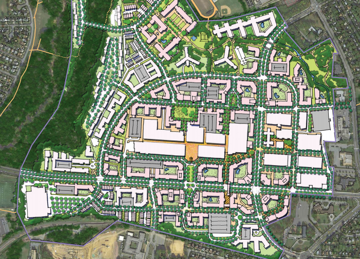
Potential future layout of the area surrounding Prince George's Plaza station 2035 vision of M-NCPPC’s TDDP by M-NCPPC.
In 2015, the Maryland-National Capital Park and Planning Commission (M-NCPPC) published its Transit District Development Plan (TDDP) and Transit District Overlay Zoning Map Amendment (TDOZMA) for the Prince George’s Plaza station area. In addition to proposing a near-complete buildout of the mall parking lot, page 79 of the document encourages evaluating lowering the speed limit on East-West Highway from 40 mph to 30 mph, reducing the widths of travel lanes, upgrading pedestrian crossings, and street trees as enhancements for the pedestrian environment. It also proposes overlaying the lots with a grid of named streets through the parking lots to facilitate the eventual construction of urban-style buildings.
As of now, the mall and its parking lots do not appear to be going anywhere. But as the suburbs inside the Beltway continue to urbanize, an opportunity to set a bold example exists for a county that lags in sustainable and pedestrian-friendly communities. Prince George’s Plaza could become the downtown for a constellation of communities in a densely populated, up-and-coming area of the region. The county just needs to show initiative and meet all the goals of M-NCPPC’s plan.
