Jim Graham’s northern Circulator
At last night’s Neighborhood Circulation Study in Adams Morgan, Councilmember Jim Graham handed out his own proposal for how to bring the Circulator north into Adams Morgan. DDOT already expects to add the route in 2009.
Here is a scan of the handout:
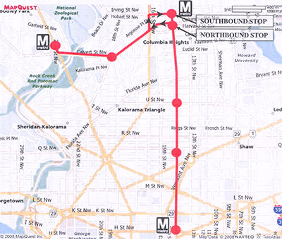
Graham took pains to emphasize that this is only an idea for discussion, and he’s not wedded to the specifics of the plan. Under this proposal, the new Circulator route would make very limited stops to connect people between Metro stations at Woodley Park, Columbia heights, and McPherson Square (hitting all lines) and the major commercial districts of Adams Morgan, U Street, and Logan Circle.
Richard Layman suggested more stops, like one at the Safeway on Columbia Road or in Mount Pleasant. Other meeting attendees chimed in with suggestions of other places for the bus to stop.
Mount Pleasant might be a good stop location as well if the bus can navigate there without too many turns. But consideration of stops at other neighborhood destinations like the Safeway muddy the purpose of this bus, which is clearly to primarily transport visitors from elsewhere in DC and the region to and from our businesses.
Visitors probably aren’t going to the Safeway, and residents who take a bus to the Safeway probably want that bus to stop closer to their houses than merely at 18th and Columbia or at the Columbia Heights Metro. There ought to be frequent bus service along there (i.e. the 42), to serve local needs. But as Graham staff member Jonathan Kass pointed out at the meeting, the shorter the route, the greater frequency we can get for the money. Each stop adds time and therefore cuts frequency.
If we want a speedy service to get visitors to and from the area, DC should take some important steps to make the service accessible to the casual user:
Make the bus frequent. It should run at least every ten minutes. Less, and it stops being the easiest way to get to and from the area, pushing people to drive instead.
Make signage from Metro stations incredibly clear. When someone exits a Metro station, they should see hard-to-miss signs telling them exactly where the stop is located. The little tiny bus signs we have now, even for the Circulator, are not visible enough. This is especially important at Columbia Heights if the northbound and southbound stops are separate and may be a block away from the Metro escalator.
Provide real-time information. There should be electronic signs at the bus stops telling visitors when the next bus will arrive. This is useful for everyone, but even more vital for first-time or occasional riders who will wait nervously, unsure if the bus is actually coming or if they are in the right place. Information gives that reassurance. Another electronic sign in the connecting Metro station would be a great way to both make signage clear (as above), ensure people know about the route, and provide valuable information.
Add the route to the Metro map. The Metrorail map is the way most people perceive the city. Residents know their local bus lines, but little else. We should strategically add visitor-oriented limited-stop services to the map, like this:

I do wonder about calling this the “Circulator.” On the one hand, the Circulator is branded as a tourist and visitor bus service. On the other hand, the existing Circulator makes very frequent stops and is quite slow (45 minutes from Georgetown to Gallery Place). People might assume this bus does the same. Also, if it only stops at McPherson, this Circulator wouldn’t make a very convenient connection with the existing one on K Street.
I’d like to see something faster on the K Street route as well. Maybe we need a “Circulator Express” along with the local service there, and make this a Circulator Express? If we did that, one day a Circulator Local could even run on this northern route, satisfying those who want additional stops. Better yet, let’s make this a streetcar!