Plans for Georgetown’s C&O Canal meet misanthropic planning attitudes

Canal area 13 by Ted Eytan licensed under Creative Commons.
The Chesapeake & Ohio (C&O) Canal in Georgetown is largely a desolate place, but a new plan aims to bring life back to the canal as it historically had. But not everyone thinks a livelier C&O Canal is a good idea. The Committee of 100 on the Federal City, a local preservation nonprofit, has called the plans an ill-advised attempt to recreate New York’s wildly sucessful “High Line” park.
What the canal plan proposes
The National Park Service, which controls the canal, has been working with the Georgetown Heritage, the DC government, and Georgetown’s Business Improvement District to create a new plan for the canal. Georgetown Heritage, a nonprofit which advocates for the canal’s preservation, calls it “unlocking the potential” of the canal, which opened in 1831.
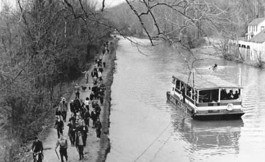
It will allow the Park Service to run a mule-drawn boat on the canal, as it did until 2011 but had to stop because the locks and boat were falling apart. During the canal’s heyday, mules pulled boats full of cargo along the canal, and this interpretive historic ride evokes that and educates people about the history.
The current towpath has a number of narrow “pinch points” where it is no more than two to four feet wide, too narrow for people with disabilities and which make it difficult for mules and people to both share the path. Therefore, the plan suggests widening the towpath in narrow places, either by leveling and paving some grassy areas on either side of the path, or potentially by adding a cantilevered section over the current waterway.
Options for the towpath by National Park Service.
The rest of the plan focuses on six key areas. On the east side, there is “Mile Marker Zero” where Rock Creek meets the Potomac River, near the Thompson boathouse; the “Rock Creek Confluence,” where the canal splits off from the creek; and “The Locks,” the sequence of locks around 30th Street.
Farther west, you have the “Wisconson Avenue Cut-Out” where Wisconsin crosses the canal; the “Market Plazas” with Dean & Deluca on one side and a plaza, called Fish Market Square across; the “Stone Yard,” close to the Key Bridge and where there was historically a stone yard; and the “Aqueduct,” the remaining abutment of what was once a bridge over the Potomac.
The seven areas of the plan by National Park Service.
For each area, there are two options, one which makes a few changes and one which makes a few more. Nowhere does the plan massively overhaul the canal and it tries to be acutely respectful of the canal’s historic character.
A few places will add more access points, like at Mile Marker Zero, which would include a new bridge. There is an actual marker at the start of the 184.5-mile C&O Canal Trail, but staff for the National Capital Planning Commission (NCPC) pointed out that it’s “difficult to see and access, as it is located on the southern end of the peninsula and hidden behind existing boat storage.”
There would be a new bicycle and pedestrian bridge connecting the Rock Creek trail to the Capital Crescent Trail, potentially under the existing K Street road bridge. Farther down, by Wisconsin Avenue, the plan suggests stairs and potentially an elevator between the road and the canal.
Option A for the Market Plazas by National Park Service.
Elsewhere, the plan tries to create more useful public spaces, like at the Market Plazas and Aqueduct. The Market Plazas would get ramps to allow for stroller and wheelchair access and a “gongoozling platform,” an English term for a place people gather to watch canal traffic. Option B, the option with more changes, includes some terraced seating on one side and a canopy over the Fish Market Plaza (what’s now an open brick plaza with some tables, at the end of Grace Street across the canal from Dean & Deluca).
The Aqueduct would become a more usable public space, potentially with a trestle reflecting the trestle that was originally at this spot. And at the Locks, the current Mule Yard, where the mules used to stage, would get more trees and some demonstration mini locks for educational purposes.
Option B for the Aqueduct by National Park Service.
When this was presented to NCPC, Georgetown Heritage board member Adam Metz said, “We anticipate this one-mile stretch being an inviting center for social gatherings, art, immersive learning, contemplation, and recreation.” Metz noted that the legislation establishing the park says its purpose is “to preserve and interpret the 19th century transportation canal from Washington, DC to Cumberland, Maryland and its associated scenic, natural, and cultural resources, and to provide opportunities for education and appropriate outdoor recreation.”
Bob Peck, formerly with General Services Administration (GSA), said, “When I have visitors, I always bring them to Georgetown, want them to see the towpath and the waterfront park and it is particularly difficult to access. There is an opportunity here to balance history and interpretation with the best aspects of an urban park in our time.”
Peck also pointed out that the Park Service’s standards say it “will seek to provide the highest level of accessibility reasonable, not simply the minimum level,” that running or walking on the towpath today is “a challenge,” and that “the original engineers intended that there be a 12-foot wide towpath all the way through Georgetown.”
The Committee of 100 says it’s too much
DC’s self-descibed “oldest planning nonprofit,” the Committee of 100, generally stands against change, and here has staked out a position beyond other historic preservation entities.
de teel Patterson (“Pat”) Tiller told NCPC,
Not appropriate are the wide-scale use of landscapes, perennials, tree groves, all while pretty, all while wonderful, everybody will love them, are not appropriate for the historic canal, whose historic nature was and continues largely gritty and industrial. Historically, the canal was neither garden nor local recreational park. The aqueduct ruin is neither a wildflower garden nor the setting for an ersatz historic bridge truss. …
The wholesale introduction of recreational floating boardwalks, conversation pits, and hammocks we believe are inadvisable. They no doubt, again, will be wildly popular. These choices are incompatible with National Park Service policies and incompatible in material design and historic character with the canal.
Stephen Hansen, the committee’s chair, followed up with a Washington Post op-ed that repeated many of the same phrases. He also called this “a glorified ‘tot lot’ — a DC version of the wildly popular Manhattan High Line,” and added, “The canal is a rare survivor of our republic’s early industrial past. It is, by nature, gritty and industrial. It is neither a city park nor a playground; not a parcourse nor a gym.”
At the NCPC meeting, Evan Cash, who is committee director for Council Chairman Phil Mendelson and represents him on the commission, said, “I almost see this as the Wharfing of Georgetown,” referring to the popular Wharf area also along the water. He said maybe the mules could be up by Great Falls instead of in Georgetown, that people can already boat on the Potomac right nearby, and that we should “scale back the amount of stuff that we’re doing here.”
Mena Wright of the GSA disagreed with the Committee of 100’s Tiller, saying, “If the canal is not adapted to contemporary use and improved, it will look like it looks today, which is pretty dreary.” But, she also said, this plan “feels like too much.”
Peter May of the National Park Service pointed out that people did canoe and kayak on the canal before it was recently drained for restoration. He also suggested they might try a temporary dock to see if it is successful.
May noted that nobody is trying to replicate the High Line. “We can’t handle the crowds’ effect,” he said. “Even the High Line can’t handle the crowds that they get now but we couldn’t do it here. So we have always been trying to exercise a certain amount of restraint.”
What does “gritty and industrial” mean exactly?
Tiller and Hansen argued that a canal with more activity and more landscaping isn’t in keeping with the canal’s past, but didn’t really grapple with whether today’s character, of a falling-apart ruin, is either. Vegetation has grown in, often for the better, but which gives the canal a decidedly different appearance than when it was active.
Image by National Park Service.
Perhaps the plan should include some more big piles of rocks instead of beds of flowers, but that’s not what the Committee of 100 was recommending. Hansen decried what he called “shopping-mall-quality paving of the 190-year-old dirt paths,” though without reference to why he thinks the paving will be low quality. However, seeing as the canal hosted an actual stone yard, pavers could be seen as quite historic. But historic photographs show far more activity along the towpath than we see today.
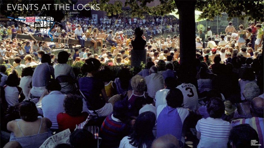
In fact, the Park Service used to host concerts in the Mule Yard in the 1970s, like this photograph, exact date unknown, provided by Georgetown Heritage:
This misanthropic sentiment pervades too much of DC planning debates
Running through C100’s comments, Cash’s comments, and others is a certain sentiment that Washington should be stately and largely devoid of activity. In the lobby of NCPC is a large model of the federal core of the District as altered in NCPS’s 1997 Extending the Legacy plan. This model shows the elegant buildings and long vistas. What it doesn’t show are people. (There are a couple of boats.)
Image by NCPC.
There is nothing wrong with models unless we let them dictate our policies. But too much advocacy around parks in the District would seek to make it as static as this model. The Committee of 100’s 2009 testimony on DC’s CapitalSpace parks plan contains no mentions of words like “play,” “sport,” “relax,” or “fun.” The only priority is vistas. The best park is one with nothing interrupting your view of a distant point.
C100’s views reflect a misanthropic strain of planning. It prioritizes the city as it appears descending in an airplane along the river into DCA. It favors the suburban viewpoint of the person who drives into the city on the occasional weekend to visit a restaurant or a museum. It can appeal, certainly, to the out-of-town architects that make up some of NCPC or the Commission of Fine Arts and who can visit Washington, stand in the midst of the model, and then go home to their families in other cities where there is fun to be had.
I live two miles away and have never been to the Zero Mile Marker, in the Mule Yard, or atop the Aqueduct. I have enjoyed the waterfront park and promenade at Washington Harbor many times. Having places that are either hard to reach or obscure works well for a “get-off-my-lawn” perspective, and that’s the Committee of 100’s philosophy, only with the entire District as said lawn. Or for certain Georgetown residents who like having the canal but wouldn’t like other people going there.
Cash’s statements about how the Wharf can be lively and the C&O Canal needn’t be are disappointing, because the city surely has room for — and in fact needs — multiple interesting places, each with its own character. As it grows, many of these places also grow crowded. Georgetown is certainly historic, but the canal should be able to retain some of its historic character — however one might interpret an economically failing “fetid” “cess-pool” with mules and rock piles for today — while also serving people.
At the NCPC meeting, Peter May of the Park Service said, “We also live in fear of over-activation in many parks. I don’t think I can go into a room with a landscape architect without somebody telling us about needing to activate a particular space. And I appreciate that and understand the desire to it but sometimes we also have to have our quiet places as well.”
Quiet places are indeed welcome, but DC has a lot of those. Too many, probably. Most circles and squares are largely empty expanses of grass, maybe with a statue of someone on a horse in the middle. The city is full of memorials, many of which commemorate wars and are designed to be somber places of reflection. Though many also draw enormous crowds, in many ways these places are designed to be inhospitable to those crowds, to ask them only to walk (long distances) to bow the head and then leave and don’t offer much to do or places to sit nearby.
Many world capitals manage to have elegance in spades and also do a better job of welcoming people. They don’t have a pervasive notion that the city needs to look like a model and people just make the model messier and more cluttered.
As Peck said, “[The C&O Canal] is a wonderful resource, it is in fact a National Park, but also an urban park. It needs to serve visitors to Washington. It needs to serve the historic Georgetown community. And there is an opportunity to do that while emphasizing the mission that the park has of interpreting and reflecting on its industrial history.”
Plus, this park is 184.5 miles long and the urban part makes up only one of those miles. There are 183.5 more miles of quiet places regardless of what happens in Georgetown. Maybe one mile can be lively?
The Commission on Fine Arts will review the canal proposals on Thursday, July 18, followed by what are likely to be many more rounds of revisions, public meetings, and approvals.
Correction: The original version of this article included a quotation about the canal’s “fetid” nature which actually referred to the Washington City Canal. The quotation has been removed.