Here are the answers to whichWMATA week 108

On Tuesday, we featured the 108th challenge to see how well you knew the Metro system. Here are the answers. How'd you do?
This week, we got 46 guesses. 35 got all 5. Great work, everyone!
This week, all of the pictured stations were shot through fences, which made for some interesting perspectives.
The first image shows NoMa station seen through the fence adjacent to the Metropolitan Branch Trail. There were several clues that should have made this a fairly straightforward guess. The fence here is different from the others by being square and painted white.
In the background you can see a signal gantry over the Union Station throat. Contrary to what some of you mentioned, this does not support the catenary, though that is also visible, indicating that this is a station along the electrified Northeast Corridor.
Finally, you can also note the newer style light-tree that replaced the traditional outdoor station pylon in the 2004 stations. A few of you pointed out that part of the station name was visible, (“lluadet U”). I'll point out that it can be difficult to get pictures without the station name. I do my best, but occasionally they slip in. Sorry to make it too easy.
45 knew the right answer.
The second image shows East Falls Church. This fence runs along the edge of the station parking lot and separates it from the westbound lanes of I-66. Of the freeway median stations, only East Falls Church is in a freeway with just two lanes in each direction. The Dominion substation along 19th Road is also visible in the background.
44 figured it out.
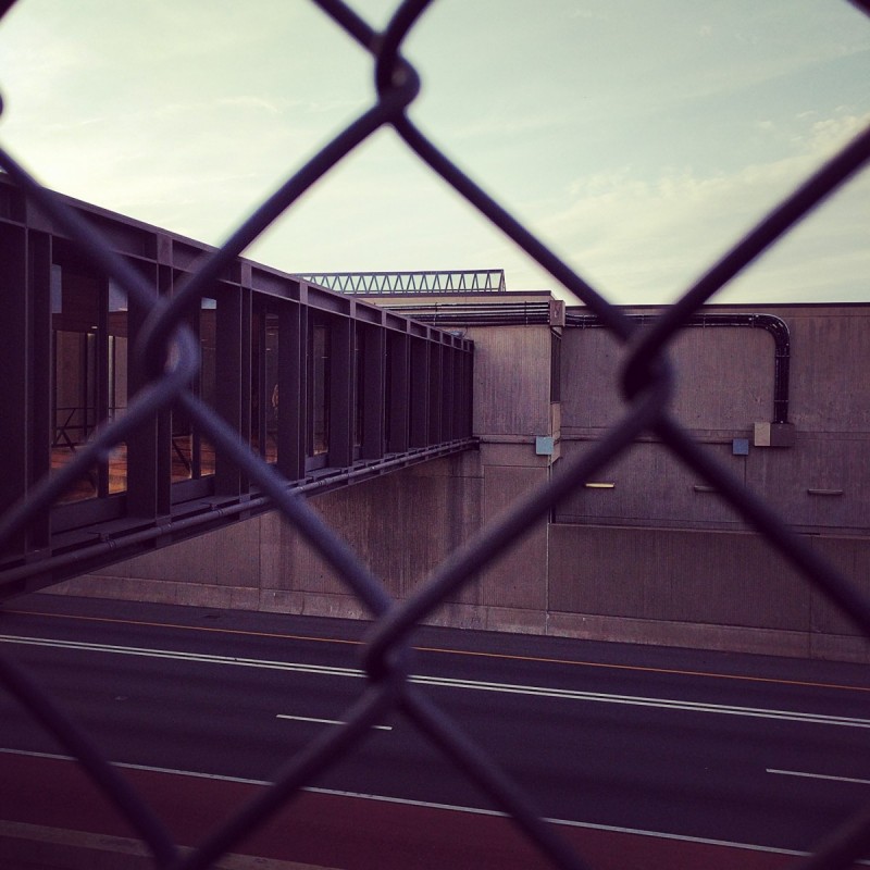
The third photo shows Vienna from the south side of the station. This is also a freeway median station, but you can discount Wiehle Avenue because the architecture doesn't match. Of the four Orange Line stations in the median of I-66, three have entry bridges over the freeway. At West Falls Church and Dunn Loring, there is just one bridge. At both of those stations, the bridge connects to the south side of the station, with no connection north of the freeway.
At Dunn Loring, the bridge is at the western end of the station, which means looking toward the station from the bridge's landing on the south side, the station would be to the right. So that doesn't fit this picture, where the station extends to the left from the bridge.
At West Falls Church, the station is mostly left (west) of the bridge, however, the eastern end of the platforms extends beyond the structure housing the mezzanine, and would be partially visible from this angle. Additionally, the eastern end of the mezzanine structure at West Falls Church doesn't extend far beyond the right side of the bridge, but it does in this image.
That leaves Vienna. The station platforms are entirely to the left of the bridge from this perspective. The additional structure to the right houses station support rooms that aren't present (at least in this location) at Dunn Loring and West Falls Church.
The other clues that could have helped you narrow this down relate to the freeway itself. Closest to the station, the left lane is separated by a double stripe. That's because it's an HOV+3 lane, which isn't present at West Falls Church and is simply dashed at Dunn Loring to allow express lane users to enter to get to the I-495 left ramps. On the right side, closest to the camera, you can see the red shoulder lane. These are only located close to Vienna.
39 answered correctly.
The fourth image shows Braddock Road station from the Potomac Yard Trail. This architectural style is only present at two stations, but you should be able to discount King Street for two reasons. First, King Street has two separate sections of canopy (to preserve the view corridor down King Street itself), and the northern portion of the canopy is at the very northern end of the station, and would be visible here, if this were King Street. You can tell the view is from the west because of the RF&P Railroad in the foreground.
Second, were this King Street, from this perspective, you'd be able to see the VRE and Amtrak platforms at Alexandria Union Station. 44 guessed Braddock Road.
The final image shows Eisenhower Avenue, viewed from the sidewalk on the ramp connecting Huntington Avenue and I-495 to Stovall Street. Because the station is elevated, that narrows the field considerably. You should have also been able to guess that it was a side platform station because you can see the elevator shaft for the Huntington platform. If this were a center platform station, the elevator wouldn't be visible, since it would be between the tracks. You can also note the modified Gull I canopy, like at Cheverly, but with the escalators going down to the mezzanine rather than up.
44 came to the correct conclusion.
Great work, everyone. Thanks for playing! We'll be back in two weeks with week 109.
Information about contest rules, submission guidelines, and a leaderboard is available at http://ggwash.org/whichwmata.


