See a subway map… of bike lanes and trails in our region

Image by Michael Graham used with permission.
All in all, the Washington region is pretty bike-friendly, with lots of trails and bike lanes everywhere. To show how many of them connect, designer Michael Graham created a map that shows some of the area's most popular bike routes in the same style a subway map shows the lines in a rail system.
There are two versions of Graham's map: the one above and a second one that's basically the same thing but overlaid on a map of the region that shows key roads and parks.
Image by Michael Graham used with permission.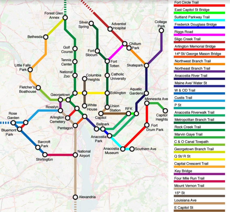
If you're thinking you just saw these, it might be because you did. Last week, CityLab published subway-style maps Graham created of of bike networks in London, San Francisco, Denver, and the Washington region. But after receiving a good deal of feedback on what he had and hadn't included in his Washington map, Graham decided to do an update.
Here's an earlier version of his map:
Image by Michael Graham used with permission.
Among the changes Graham made were adding infrastructure south of the Anacostia River like the Marvin Gaye and Fort Circle Trails, along with the 15th Street protected bikeway. The older map also includes East-West Highway and Irving Street, but those are gone on the new version because they're not actually that easy to bike on.
Graham says he also wanted to include a few other major pathways, like the National Mall and Roosevelt Bridge, but didn't have space.
“Other issues I am attempting to resolve are how to depict a trail that continues off the edge of the map (such as the Mount Vernon Trail), how to indicate that Q and R are one-ways, how to show that the Anacostia Riverwalk Trail is on both banks of the river, and how to overcome the crowding near the White House so each node can be labeled.”
“I'm also grappling with the fact that all of the lines in my maps are equal in width, implying that the routes are of equal quality,” he adds. “In fact, the routes are not homogeneous; most people would consider an off-street trail such as Mount Vernon to be superior to (and safer) than an on-street bike lane.”
But even if they are a testament to an ongoing process and inexact science, Graham's maps are sure to be useful to people wanting a snapshot of major bikeways, lanes, and trails around the region.
“I try to live by this philosophy,” says Graham. “Don't let the perfect become the enemy of the good. The 'first iteration' of the map you saw was actually probably about the tenth iteration for me.”
Thumbnail: Image by Michael Graham used with permission.