A safer bike ride through Rock Creek Park is on the way
Later this year, work will begin to reconstruct Beach Drive and parts of the Rock Creek Park Trail. The road will get a lot of work that should mitigate the environmental damage it causes, and the trail— in particular, three spots that consistently give cyclists and pedestrians trouble— will get wider.

A cyclist navigates the National Zoo tunnel under Administration Hill. Photo by Jay Mallin on Flickr.
Headed up by the Federal Highway Administration, the project should take between two and three years. It will focus primarily on Beach Drive, a 6.5 mile long road that runs from the Maryland state line to the Rock Creek and Potomac Parkway, rehabilitating nearly a dozen bridges and rebuilding the roadway and adjacent parking lots.
New pavement markers and centerline rumble strips will also go in, along with new steel-backed timber guardrails and better lights and signs.
To mitigate stormwater runoff, stormwater management elements like bioretention ponds and bioswales will go in at strategic points along the road, and workers will stabilize the creek bank with retaining walls.
In addition, DC Water will take the opportunity to add 16 manhole vaults to the Rock Creek Main Interceptor beneath Beach Drive. This will allow DC Water to rehabilitate the interceptor and Beach Drive sewers at a later date without cutting Beach Drive’s newly-added asphalt.
Rock Creek Park Trail is a big part of the project
As part of the road rehabilitation, the project will resurface and widen parts of the Rock Creek Park Trail in the sections closest to Beach Drive.
The main section of the Rock Creek Park Trail is a 5.2 mile stretch from Peter’s Point along the Potomac River, just south of the Roosevelt Bridge, to Broad Branch Road, near the Forrest Hills neighborhood. Another 0.7 mile long section starts north of there at the intersection of Joyce and Beach Drive and then follows Beach to Bingham Drive.
The FHWA work will focus on a piece of the main section from Shoreham Drive just south of Connecticut Avenue to Bluff Bridge just south of Tilden Street.
Changes to several problem areas along the trail, which users have long said were dangerous, will be a signature of the project.
The tunnel that runs under the National Zoo’s administration building is currently an unappealing option for cyclists and pedestrians because there is little space set aside for them, and what is there is totally unprotected. As of now, it’s the only option for getting through the park when the trail section that runs through the zoo is closed.
To make it more appealing, the FHWA will narrow the travel lanes inside the tunnel and widen the sidewalk from two feet to five feet, with a new 21 inch tall crash-worthy railing. “Cyclists Must Dismount” signs will also go up.
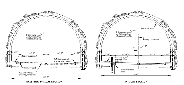
FHWA will widen the sidewalk through the Zoo tunnel. Image from US DOT.
Just south of the Zoo tunnel, the trail currently crosses Rock Creek on a notoriously narrow five foot wide sidewalk. The FHWA will build a new 11 foot wide, 140 foot long bridge just upstream from the existing zoo tunnel bridge that will serve as the new trail bridge. The existing sidewalk will also remain.
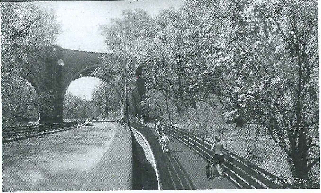
Rendering of the new trail bridge adjacent to the Zoo bridge. Image from US DOT.
Another trouble spot is where the trail crosses Shoreham Drive, the ramp that runs from Beach Drive to Calvert. There, trail users must cross two lanes of fast moving traffic on a diagonal crosswalk without the aid of a traffic-control device.
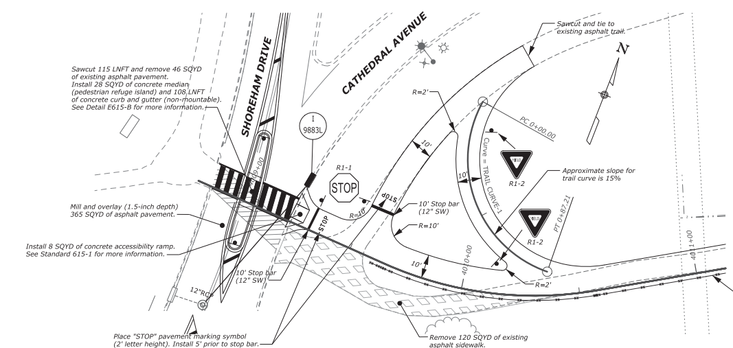
Shoreham Drive intersection and trail reconfiguration
Already improved once less than 10 years ago to remove the old dual crosswalk configuration, the crosswalk will be straightened to take the shortest path across the road. The crosswalk will also be widened to 12 feet, and include a pedestrian island. The trail just north of there will also be straightened, and the intersection with the trail along Cathedral Avenue will get separate paths for those going north or south.
The trail is getting work in other places too
The FHWA will pour new asphalt, straighten the trail in several places, and widen it to ten feet in most places, eight in others (it’s currently between six and seven feet wide in most places).
The FHWA will also construct a new trail, running from Porter Street to Bluff Bridge and connecting to a 0.8 mile long trail that DDOT plans to build later along Piney Branch Parkway from Beach to Arkansas Avenue. All trails will be designed for speeds of 18 mph (designated speeds for bikes mostly have to do with the turning radius and the amount of space at turns).
Delays and completion time
The project, promised since before the adoption of the Park’s General Management Plan in 2006, has been delayed again this year. Last year WABA announced that these projects would start in the fall of 2015 and then in December the Park Service said they would start this spring, but since then the proposal due date has slipped from November 5th to March 29th, putting them a little less than five months behind, with a “no earlier than” date of August 2016.