Here are the answers to whichWMATA week 54
On Tuesday, we posted our fifty-fourth photo challenge to see how well you know Metro. I took five photos in the Metro system. Here are the answers. How well did you do?
This week, we got 26 guesses. Four of you got all five right. Great work, Peter K, Mr. Johnson, Justin…, and Patrick!
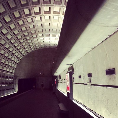
Image 1: Rosslyn
The first image shows the lower level of Rosslyn station. You can easily narrow this down to Rosslyn and Pentagon because of the split level design, which the pair of stations share. The reason for the design is because lines diverge immediately adjacent to the stations.
However, in this image, you can distinguish Rosslyn from Pentagon because the elevator between the two platforms is at the far north end at Pentagon, and would be visible here if picture were of that station.
Eighteen of you deduced that this was Rosslyn.

Image 2: Silver Spring
The second image shows the western side of the main entrance to Silver Spring. The view here is from the plaza between the NOAA buildings. The NOAA buildings were featured in week 43.
In addition to the buildings, the other clue is the sign for MARC trains, which should narrow this down to one of five stations. Of the Metro stations that are co-located with MARC stations, only Silver Spring has buildings directly adjacent to the station.
Fifteen figured this one out.

Image 3: West Hyattsville
The next image is also in Maryland, though in neighboring Prince George’s County. It shows West Hyattsville from the Northwest Branch Trail. The station has unique design, so that was the primary clue. The other main clue was the bucolic setting. Even among the sparsely developed Prince George’s stations, West Hyattsville stands out for being completely devoid of nearby development.
We featured the unique architecture here in week 8. In week 47 we also featured an angle showing the station’s utility rooms, which are visible at right here.
Thirteen correctly guessed West Hyattsville.

Image 4: Judiciary Square
The fourth image is from Judiciary Square. A portion of the National Police Memorial is visible here. The vantage point of the picture is from within the Shady Grove platform’s elevator. It should have helped you figure that out if you noticed the “bike on rail” guidelines sign, which Metro has posted in most elevators.
We used an image that included the Police Memorial in week 20, though the angle was quite different.
This proved to be the hardest image. Only six got it right.

Image 5: Crystal City
The final image shows the entrance to Crystal City. The escalator canopy is standard, of course. But the matching breezeway to the left is not. It leads the way to the station’s bus loop, which is located under the building visible in the background.
If you look very closely at bottom left, you can just make out a digital next bus sign at the Metroway stop. Few bus stops have these, but it wasn’t a primary clue because it was hard to spot.
Fourteen were able to come up with the right answer.
Thanks to everyone for playing! Great work. Stay tuned. We’ll have five more images for you next week.