The Metropolitan Branch Trail is going to get longer
The Metropolitan Branch Trail is a popular way to get between Brookland and Union Station on bike or foot, but it’d be even more useful if it went farther north toward Maryland. DDOT just unveiled preliminary plans for making that happen.
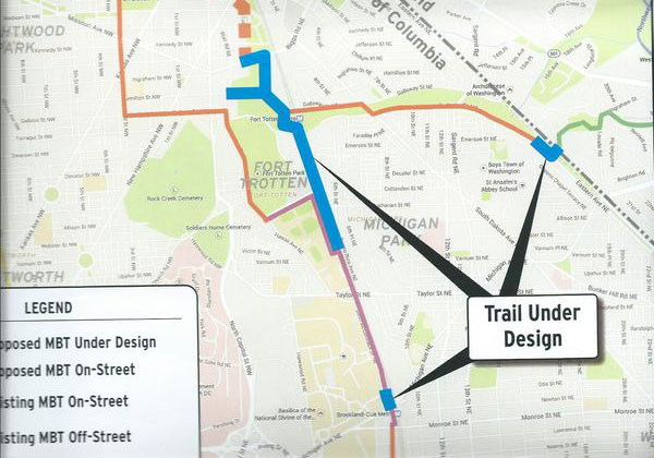
Parts of the trail that are under design. All images from DDOT.
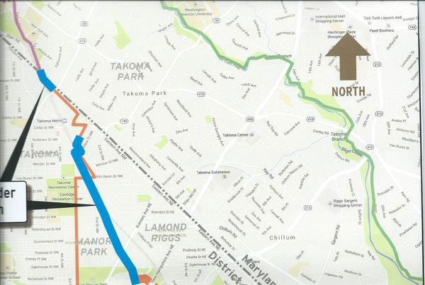
People have been waiting almost two decades for DDOT to finish the trail. Last weekend, the agency presented preliminary design plans that detail what the trail, along with the complimentary Prince George’s County Connector, will look like between Catholic University, its current end point, and Maryland.
Parts of the trail will be on the road and parts won’t. Sometimes it will run through green space and sometimes it will be a side path. Other times it will be jammed, as elegantly as possible, between an in-use trash transfer center and cement plant on one side and an active rail line on the other. Call that a drainage ditch-to-trail conversion. The path will vary from 12 feet wide, which is ideal, to ten.
Here’s a tour of what the trail is going to look like
The northern leg will start at the Brookland-CUA Metro. Trail users will pass through a redesigned Catholic University side of the Metro Plaza, and from there they’ll use the existing side path, which was built in 1999 and is in purple on the image above, to get to Fort Totten Park and the trash transfer center. At that point, the trail will squeeze between the industrial facilities mentioned above, separated by a concrete retaining wall and a low fence.

Trail between the cement plant and railroad tracks.
Continuing north, the trail will then turn left to go over the Metro tunnel, then sharply right to get back to 1st Place NE. From there, it will continue north, but also meet the Prince George’s County Connector to the east and an existing trail to Gallatin Street to the west. At 1st Place, there will be both stairs and a ramp.

Trail map near the Fort Totten Metro.
The Gallatin Street connection to the west will have a better turn radius, a wider and better surface, and a more trail-like feel. The Prince George’s Connector will be an on-street route on Gallatin and South Dakota Avenue with a small trail connection from Eastern Avenue to the boundary.

DC trail portion of the Prince George’s County Connector.
Heading north, the trail will be a sidepath along the west side of 1st Place NE and then the south side of Riggs Road. There will be no bridge over Riggs, and no trail east of 1st Street on National Parks Service land. Routing the trail through NPS land was considered in the 2004 draft design, but the federal agency ultimately refused to allow it. There will, however, be an improved crossing or Riggs at 1st St and a sidewalk on the east side of 1st Place.

1st Place NE at Riggs Road.
The trail will run on roads and sidewalks along 1st Street NE until crossing New Hampshire Avenue and heading west on McDonald Place to Blair Road. At Blair Road, the trail will again transition to a side path. Just north of McDonald, the trail will double as access to the Oglethorpe Community Garden, meaning a small bump-out for garden loading and unloading and limited access for vehicles on a 12 foot wide section.

Oglethorpe Community Garden.
North of Peabody, cutting a northbound lane of Blair Road will allow for landscaping and some additional curbside parking. There will also be several improved crosswalks across Blair.

Along Blair Road, narrowed to add parking.
Just north of Tuckerman the trail splits into two six-foot sections for part of a block…

Trail map near Tuckerman.
Update: Since publication, Toole Design has modified the alignment so that it does not split. That map can be seen below.

Updated map of trail near Tuckerman
…before reconnecting into a protected trail (separated by a wall) along a lane-reduced Blair Road.

Blair Road with protected path.
The trail will turn under the railroad tracks at Aspen, and then along the side of Sandy Spring before returning to an on-street route along Maple, Carroll, Ceder and Eastern.

Sandy Spring.
The last piece of the trail is a block-long section on the southeast side of Eastern/Takoma Avenue from Piney Branch to the existing terminus of the Maryland section of the trail along Takoma Avenue.

Connection to Montgomery County.
It’s unfortunate that the Riggs Road Bridge could not be included, just as it was disappointing that the Monroe Avenue underpass could not.
It’s also unfortunate that the Prince George’s County Connector is almost all going to be on-road in DC when there is a suitable green strip there (owned by NPS, of course) that would work well.
DDOT plans to finish this preliminary part of the design process by the end of 2015, and the final design should be complete by the end of 2016.
Cross-posted at TheWashCycle