Get your March Madness on with two games that test your city smarts
In the mood for yet another bracket? Or maybe after filling one out, you’re looking for a guessing game where you’ve at least got some idea of what you’re doing? These two games are fun ways to test what you know about cities.
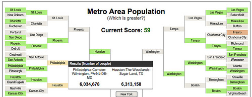
The first is the Census Bureau’s Population Bracketology. You can play using either state or metropolitan area populations, choosing which of the paired “contestants” has the greater population.
Many of the choices are intuitive, but it’s often surprising to see how large many younger, Sunbelt cities have grown. The difference would have been much more obvious if the Census pitted city populations head-to-head — municipalities in the east are usually much smaller than those in the west.
Jonathan Neeley, our staff editor, said “when cities I don’t have a great gauge of came up, it got me thinking about density versus sprawl. I obviously know New York beats Jacksonville. But does Baltimore beat Riverside? Does Portland beat Orlando?”
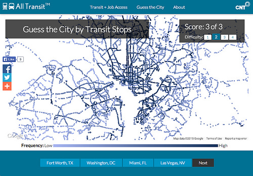
You may know populations, but how about transit lines?
If you’ve got a sharper memory for geography than for facts and figures, you might prefer Chicago-based CNT’s “Guess the City,” featuring transit stops color-coded by service frequency (drawn from GTFS data):
Not all of the choices are so obvious, though, especially in suburbs with sparse transit networks:
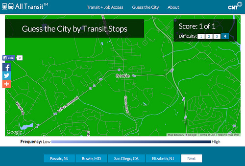
One hint: keep in mind that many eastern cities have radial street networks, whereas western cities almost always have gridded streets. Also, bigger cities almost always have denser transit networks. CNT’s site also lets users generate a color-coded “Transit Access Score” that measures how accessible any given location is via transit.