Will Charles County choose sprawl?
On the fringe of the metropolitan Washington area, a suburban county is poised to make a momentous decision. Despite the vigorous objections by many residents, Charles County could promote sprawling development that could harm Maryland’s environment, the county’s economic vitality, and the metro region as a whole.

Mattawoman Creek. Photo by Tom Zolper, Chesapeake Bay Foundation.
On May 13, the county could adopt a plan that could add some ten thousand new homes, many of them with septic systems, on land that is now forest. This is precisely what a Maryland water quality law in 2012 aimed to avoid. It would fuel a demand for new roads for long-distance commuters and severely pollute a rare and precious tributary to the Potomac and the Chesapeake Bay.
If the vote goes the other way, Charles County could promote a future that most of its residents say they want, have a positive impact on Prince George’s County and other neighbors in the region, and comply with Maryland’s environmental laws and goals.
From rural to rapidly growing
Twenty years ago, Charles County was still a fairly sleepy place. Mostly rural, with wide expanses of rolling farmland and thousands of acres of forests, this county just south of Prince George’s was just then beginning to build bedrooms for commuters in the greater Washington region.
Most commercial and residential development clustered in and around Waldorf, a stretch of urban strip commercial centers along US 301; the large planned development of St. Charles; and the county seat of La Plata, a slightly more compact town to the south. The county also hosted the tiny cross-roads communities of Bryans Road and Port Tobacco, and the government naval munitions research center in the village of Indian Head, on the Potomac River.
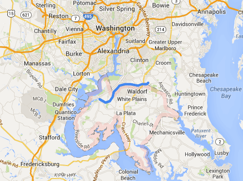
Charles County (outlined in pink) and the Mattawoman Creek (in blue). Base image from Google Maps.
The county has grown significantly since then, and is now a full-fledged part of the metropolitan Washington region. Yet there is still a vast amount of rural land in Charles County. There are still thousands of acres of forest, along the Potomac across from Stafford County, Virginia, and on either side of the lazy Mattawoman Creek. One of the best bass fisheries on the East Coast, it hosts big money tournaments and weekend fishers alike.
According to Maryland’s Department of Natural Resources, the Mattawoman is also a high-quality, productive aquatic ecosystem that ranks eighth among the state’s 137 watersheds for freshwater stream biodiversity. It is a jewel which, while stressed with farm and urban runoff and very near the knife edge of system overload, is still a rare and wonderful place.
The Cross-County Connector and sprawl plans threaten Charles County
That’s the thing about Charles County. It’s a place of contrasts.
Incomes are rising. Growth is happening, as it is all across the region. That’s not necessarily a bad thing if it brings jobs to the folks who live there now. But what form will the growth take, and at what cost to the County’s natural resources, agricultural heritage, and way of life? What do county residents really want?
Three years ago, some county leaders and businesspeople pressed forward with a plan to build a new highway, the so-called “Cross-County Connector.” Many residents felt the road was unnecessary, and local funds could instead jump-start light rail transit or improve maintenance and safety on other east-west roads without slicing through and opening up a new suburban sprawl corridor.
From an environmental perspective, it was an especially bad idea. Federal and state agencies uniformly commented adversely, refusing to issue the necessary permits.
But highways never seem to die. Nor do the dreams of bulldozed forests, carved up farmland, and unmitigated sprawl which dance in the heads of a few developers, like the dreams of sugarplum fairies in little children. At the same time, good local land use plans are sometimes stillborn.
Who killed the good plan for Charles County?
Just two years ago, the county planning staff labored over a new land use plan. It complied with a new state requirement to designate land in one of four “tiers.” It reflected existing land uses and key environmental attributes. It designed around public sewer and water to avoid septic systems, which can pollute groundwater, as much as possible.
The county held public meetings galore with local residents and businesspeople, and obtained extensive feedback. The plan that emerged seemed to reflect local desires and state requirements. It supported a prosperous and environmentally sustainable future.
The Connector was gone. The plan would keep many areas rural, conserve forests and farms, and focus growth in sensible development zones in and around existing communities. It would protect the Mattawoman, and keep additional polluted runoff out of the Potomac and the Chesapeake Bay.

Mattawoman Creek. Photo from the Chesapeake Bay Foundation.
But this sensible plan didn’t last long.
A group of businesspeople and developers quietly promoted their own version of a plan: the wonderfully-named “Balanced Growth Initiative,” or BGI. A slim majority of County politicians, in a stunning reversal, made the BGI their own instead of the plan from their own professional staff.
The BGI would have enabled an extensive amount of new sprawl, allowing spread-out development on tens of thousands of acres of forest and farmland. It would have put back the Cross-County Connector highway that had not previously received support from any federal or state agency.
Up to 52,000 new homes would have become possible, including almost 350 major subdivisions on septic systems. Additionally, with all the new hardened surfaces, more than 200,000 pounds of nitrogen-polluted runoff could have been added to the county’s waters annually, challenging the Chesapeake Bay clean-up.
In an unprecedented reaction, 14 Maryland cabinet secretaries co-signed a letter to the county slamming the BGI plan from their various perspectives. At a subsequent public hearing, hundreds of county residents expressed their strong opposition, in addition to the several thousand similar reactions the county otherwise received.
2013 polling provided comparable results, revealing what residents overwhelmingly want and what the first, good plan reflected:
- Nearly two-thirds of residents believed the county is growing too fast, and 81% opposed the plan that could add 52,000 new homes within the next few decades.
- While 70% viewed traffic as a major problem, 71% opposed the Cross County Connector, and most folks preferred bringing good jobs closer to where people live.
- 93% of the community said that if they were writing the plan, protecting local waterways like the Mattawoman, and areas like Port Tobacco, would be a high priority.
Faced with near revolt, the County Commission created a six-person, even-handed special task force to come back with a new Tier Plan. The plan the task force finally returned to the Commission was similar to the original one that the planning staff had drafted, placing thousands of acres in the two most protective land use “tiers,” as Maryland law requires.
Still dissatisfied, three of the five commissioners edited the plan. They added 9,000 acres (14 square miles) of large-lot development back into the sensitive areas of the Mattawoman watershed, which would allow 8,000-10,000 new homes on what is now forest (likely doubling impervious surface in that watershed), along with some other changes.


Left: Land use “tiers” in the original plan. Right: The current proposal from the County Commission. Note the extra developed area (yellow) around the Mattawoman Creek.
Once again, Maryland officials reacted adversely. This was not, they wrote, what state law intended for managing growth and reining in septic systems. It would lead, they said, to development in especially sensitive areas. In 30% of the development area the Commissioners added back in, it would introduce houses and people into sub-watersheds that have especially high-quality streams — which could possibly trigger a federal Clean Water Act-related review. The state’s comments force another public hearing, now scheduled for May 13th in La Plata.
Charles County is surely at a crossroads — or a precipice. This has been a long story, and of course it’s not over yet. The back-and-forth nature of this planning process is enough to produce whiplash.
As a suburban jurisdiction in the greater Washington region, the county can succumb to the seductive pull of quick development bucks and short-term revenue. It can squander precious natural resources and a way of life that its citizens obviously hold dear. And it can let obligations to provide public services to far-flung extensions of new development sap economic strength.
Or, the county can help carve out a more sustainable future for itself and the metropolitan region. More focused growth would provides genuine economic progress and strong, resilient communities for its residents and businesses. That would also let the county’s cherished farmland, forestland, wetlands and streams continue to afford a rich, balanced quality of life for its residents, and for the greater region, for many years to come. The choice is stark.