Walter Reed’s main street should be Georgia Avenue
The Walter Reed campus is one of the largest redevelopment sites in the District. It may one day become the biggest node of activity between Columbia Heights and Silver Spring. Three teams are competing for development rights, and it’s now up to DC to select which team will get the opportunity to build.
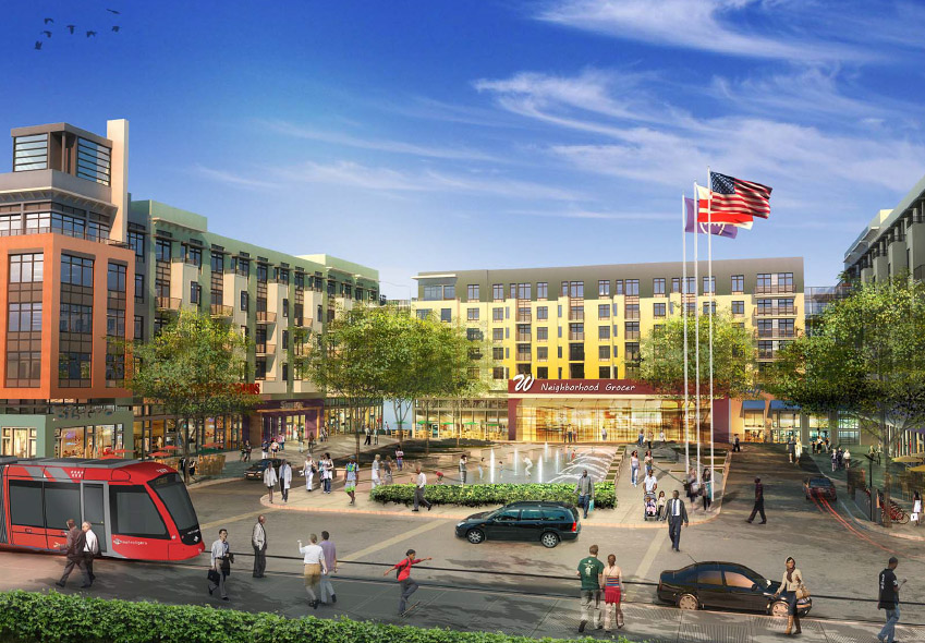
Hines’ proposal. All images from the Walter Reed Local Development Authority.
Much of the media coverage of the 3 options has so far focused on which of them might accommodate a Wegmans grocery store. But the physical form matters more than the individual tenants. To function as a neighborhood downtown, Walter Reed must be walkable, as transit-oriented as possible, and fully integrated with the surrounding neighborhood.
Specifically, Georgia Avenue must be the main street. Developers of large properties often try to mimic shopping malls and pull the center of activity inwards, towards the center of their own site, and away from the edges. That’s why Ellsworth Drive became the center of Silver Spring, and why CityCenterDC’s central plaza won’t face a public street.
But that arrangement makes a place feel artificial, and limits the spillover economic benefits to surrounding parcels. It also pushes more people to drive, when the main transit spine isn’t front and center to the densest cluster of development.
With no Metro station at Walter Reed, and Takoma station a long walk to the east, the major transit access will be from Georgia Avenue. First the 70-series bus line, and eventually streetcar. Since Georgia Avenue is both the transit spine and the community’s existing main street, it should be the heart of activity for Walter Reed.
Hines and Roadside proposals

Site plans of Hines’ (left) and Roadside’s (right) proposals.
The Hines and Roadside concepts are similar. Both propose the southern half of the property be suburban in character, with a town center clustered in the northern half.
Hines shows a public park fronting on Georgia Avenue, which would be a nice amenity. But that park has the unfortunate effect of pushing the hub of its town center back nearly 2 blocks away. One rendering even shows the streetcar pulled off Georgia Avenue, rerouted to better serve Walter Reed and more poorly serve everywhere else.
It’s harder to tell from the plans whether the Roadside proposal treats Georgia Avenue, Dahlia Street, 12th Street, or 13th Street as the main street. It appears to be about the same density as Hines, but without the town center park.
Forest City proposal

Site plan of Forest City’s proposal.
Seemingly the densest of the 3 proposals, Forest City is the only finalist team that attempts to urbanize the southern half of the property. It also maximizes building frontage along Georgia Avenue, while providing ample parks along 13th Street.
Forest City does propose to make Dahlia Street a retail spine, while they do not say what sort of land uses would front on Georgia Avenue. There may be enough added density in their proposal to support both Dahlia and Georgia as retail spines, or maybe they’d make Georgia all residential. The former would be fine, the latter wouldn’t.
At first glance, Forest City’s proposal appears to be the best of the 3, but all the development teams must release more details, especially their proposed ground-floor land uses for every street.
No matter which team is ultimately picked, a town center near Georgia and Dahlia is better for DC than what’s there today.
 Cross-posted at BeyondDC.