Upper Marlboro is too remote for most Prince Georgeans
Access to government is an essential part of a functioning democracy. When a county’s government is too far away from its citizens, it impedes many who would otherwise participate. Prince George’s County’s seat in Upper Marlboro is a particularly poor location.
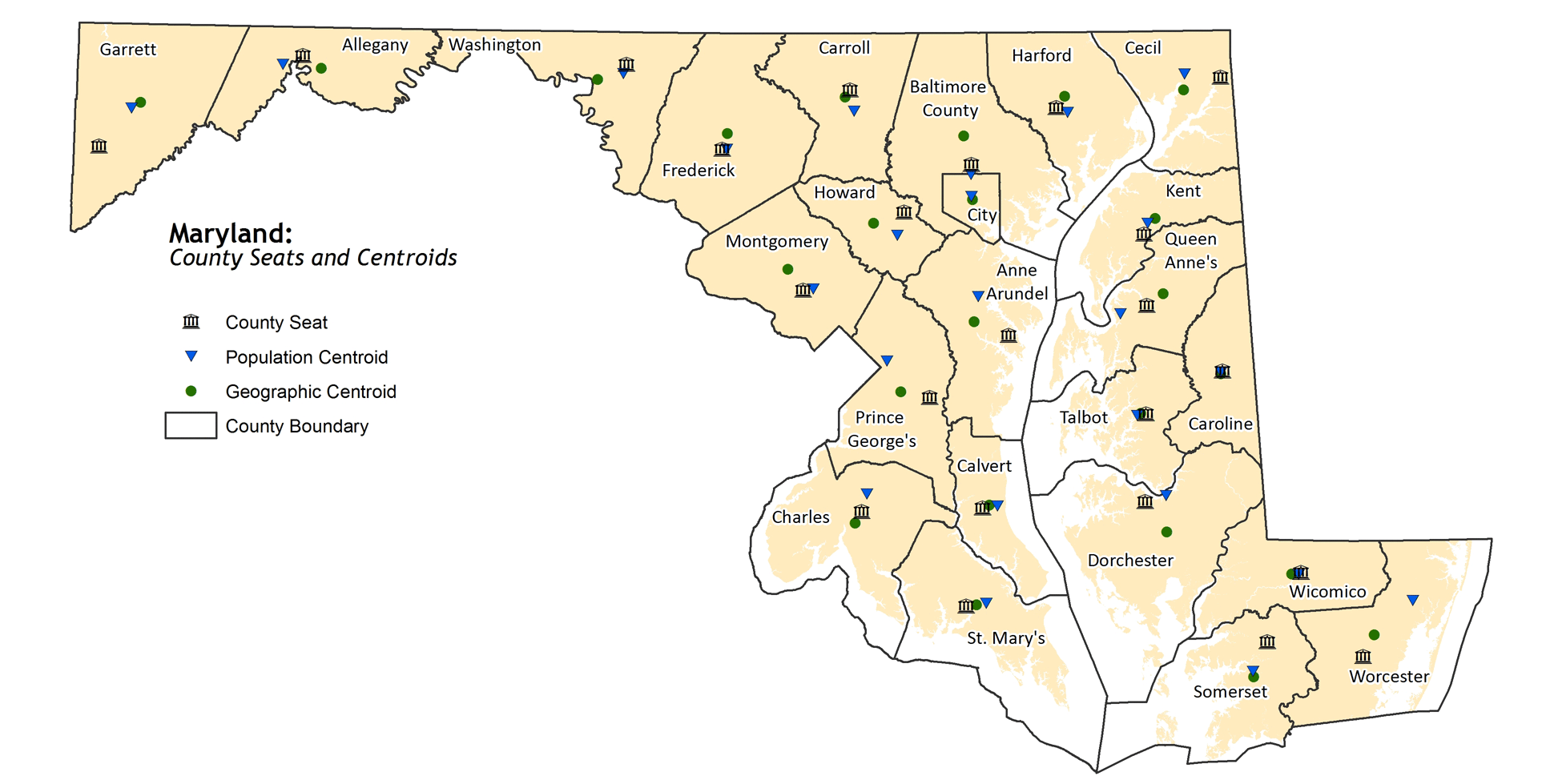
I created this map showing where the county seats relate to the geographic and population centroid of each county in Maryland:
Upper Marlboro is on the far eastern edge of Prince George’s County. The courthouse, in fact, is only 2 miles from the border with Anne Arundel County.
That means that for many residents, it is a long, tedious trip to the county seat to testify before the council or otherwise participate in events at the county’s administrative center.
For those with a car, it’s a long trip. For those without a car, it is a long, and at some times, impossible trip. The last bus leaves Upper Marlboro bound for Addison Road station at 6:40 pm. If you want to testify at the council after that, you’ll need a car.
When I was called for jury duty last year, I had to borrow a car to get there. Jurors are expected at 7:30. For people living in the northern end of the county, that means catching the 6:30 bus from New Carrollton. And if your bus doesn’t get to New Carrollton by 6:30, you’re out of luck. For example, the first bus from the north end of Greenbelt doesn’t get to New Carrollton until 6:49.
Upper Marlboro is not central
Upper Marlboro is not particularly close to the geographical center of Prince George’s County. The geographical centroid (the average latitude and longitude of all points in the county) is just northeast of Andrews Air Force Base, just over 5 miles west of Upper Marlboro.
Of Maryland’s 23 county seats, Upper Marlboro is the 9th most distant from the geographical centroid of its county. The worst is Oakland, over 10 miles from Garrett County’s center. On the other hand, Denton is less than a half mile from the center of Caroline County. The state average is 3.97 miles.
More important than geographic centrality is that the seat is close and accessible to the populace. In that regard, Upper Marlboro fares much more poorly.
Upper Marlboro is 9.66 miles from the county’s 2010 centroid of population (the average latitude and longitude of each resident’s home in the county). That’s the 2nd largest, after only Worcester County (home of Ocean City).
The distance between population centroids and county seats ranges from a high of 12.83 miles in Worcester County to a low of just 0.32 miles in Caroline County. The statewide average is 4.02 miles.
The 2010 population centroid of Prince George’s County is near the intersection of Martin Luther King, Jr Highway and Sheriff Road in the Landover area. This is about halfway between the Cheverly (Orange Line) and Morgan Boulevard (Blue Line) Metro stations.
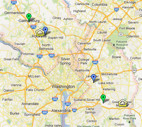
Centroids of Prince George’s and Montgomery counties. Click for interactive map. The blue dot represents the population centroid, and green is the geographic centroid.
If we compare this to Montgomery County, we find that Rockville is only 1.75 miles from the population centroid and 4.51 miles from the geographic centroid of the county.
| County | County seat | Miles to pop.
centroid |
Miles to geo.
centroid |
|---|---|---|---|
| Allegany | Cumberland | 3.74 | 3.76 |
| Anne Arundel | Annapolis | 8.42 | 6.32 |
| Baltimore County | Towson | 1.74 | 5.15 |
| Calvert | Prince Frederick | 2.49 | 1.26 |
| Caroline | Denton | 0.32 | 0.47 |
| Carroll | Westminster | 3.69 | 1.45 |
| Cecil | Elkton | 6.16 | 6.60 |
| Charles | La Plata | 3.10 | 2.20 |
| Dorchester | Cambridge | 3.67 | 6.27 |
| Frederick | Frederick | 0.78 | 2.93 |
| Garrett | Oakland | 8.56 | 10.38 |
| Harford | Bel Air | 2.10 | 2.37 |
| Howard | Ellicott City | 4.17 | 5.50 |
| Kent | Chestertown | 1.97 | 3.34 |
| Montgomery | Rockville | 1.75 | 4.51 |
| Prince George’s | Upper Marlboro | 9.66 | 5.01 |
| Queen Anne’s | Centreville | 4.70 | 3.45 |
| Somerset | Princess Anne | 5.58 | 6.34 |
| St. Mary’s | Leonardtown | 3.40 | 1.75 |
| Talbot | Easton | 1.52 | 0.95 |
| Washington | Hagerstown | 1.67 | 5.53 |
| Wicomico | Salisbury | 0.46 | 1.58 |
| Worcester | Snow Hill | 12.83 | 4.22 |
The population centroid is a constantly-changing point on the map.
In 1920, for example, the population centroid for Montgomery County was located north of Rockville. By 1960, it had moved as far south as Garrett Park, as the downcounty area urbanized. But then the wave of population growth moved north, and pulled the centroid with it.
In Prince George’s County, since suburbanization began with streetcars in the early 1900s, growth has always stayed close to the DC boundary. Even as sprawling neighborhoods began to appear throughout Prince George’s, the density of the close-in neighborhoods means that the population centroid has stayed close to DC.
Because so many Prince Georgeans live in the northern part of the county and close to the DC border, moving the county seat could make it easier for county residents to get involved in their government.
The county has already taken steps to move some departments to Largo, including the county’s Department of Public Works & Transportation.
Prince George’s should continue that trend, and moving the County Council should be a top priority.
If Largo were the county seat, it would be about the same distance from the geographical center of the county (5.16 miles instead of 5.01 miles), but it would be much closer to the population centroid (2.79 miles away instead of 9.66 miles).
Additionally, a seat in Largo would be much more accessible to residents without access to cars. Largo has a Metro station and is a transit hub for several bus routes. Transit service there lasts almost until midnight, as opposed to shutting down at dinner time, as it does in Upper Marlboro.
A seat with Metro service would also put Prince George’s in the same category as some of the other counties in the region. DC, Arlington, Alexandria, and Montgomery all have Metro-accessible seats.
Upper Marlboro is very inconveniently located. It’s time Prince George’s stopped asking its residents to slog more than halfway across the county just to participate in local government.