Posts about Public Spaces
-

Breakfast links: No free lunch
Bag fees, Bethesda to Burtonsville; WMATA employees park free; DDOT rejects Walmart traffic study; Visualize the 4/26 election; Black church turns to solar; Today in buildings; Where are the food deserts?; Using Tysons to better Fairfax; And…. Keep reading…
-
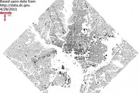
Open geographic data enables a wealth of maps
The District’s GIS data catalog is a treasure trove of interesting information. I created maps from that data and posted some each day last week. They looked at DC’s land use, the Metrobus system, Zipcar locations, buildings versus open spaces, and city topography. Figure Ground The figure ground map is a silhouette of building footprints. The whole of DC and… Keep reading…
-

Breakfast links: Cause to celebrate?
Osama death brings celebration, security; CaBi’s utility creates converts; Responsive Metro pushes bike cage; Chevy Chase a little less anti-Purple Line?; Safety rule strains track inspectors; No agreement on Nats’ Metro bill; MD cities, DC will tackle street runoff; Residents, tourists alarmed by rising tolls. Keep reading…
-

Weekend links: CaBi CaBi everywhere
CaBi in your CBA; CaBi in the CBD; Arlington businesses fine with CaBi; How to get parents to let kids walk or bike to school?; Neighborhoods exacerbate kids’ obesity; DC lacking public spaces; Reward for not using Gehry; US exceptional, and not in a good way; And…. Keep reading…
-

What trees are on your street?
Casey Trees used data from DDOT’s Urban Forestry Administration to create a great interactive map of street trees: Blue dots show maple trees, red dots are oak, pink elm, green sycamore, and yellow dots show all other trees. Keep reading…
-

Earth Day brings new community park & garden to Hill East
What does it look like when a group of neighbors, a non-profit or two, a couple of federal agencies and a handful of DC government offices partner effectively? Swing by 13th & C Streets SE, and see for yourself. Nearly four years after neighbors rallied to turn a vacant lot owned by the DCHA into a community park and garden, twenty to thirty volunteers gathered to plant nine trees… Keep reading…
-

Breakfast links: Our elected leaders
Vote now; Biddle fades at the finish; Seegars makes interracial marriage an issue; Coalitions can be contradictory; MD legislature ignored environment; Costco returns would take a decade; Boat club nixed public plaza; St. E’s at risk?; And…. Keep reading…
-
Breakfast links: What’s in a number?
Streetcar almost done; Affordable housing takes hit; Pentagon fudged on BRAC numbers; Bike thefts growing problem; Mixed neighborhoods are prefered; From one election to another; Drivers apparently oblivious; CaBi data dump; And…. Keep reading…
-

Naylor Road Metro can be safer for pedestrians
Pedestrian access to the Naylor Road Metro station is dangerous and the safety mechanisms currently in place are inadequate, including a walk signal facing into the woods. While Naylor Road is a priority site for TOD in Prince George’s County, there are several short-term solutions the county can implement to improve pedestrian safety now. The Prince George’s… Keep reading…
-

Morning links: Things on the rise
Dulles station debate heats up; Carol Schwartz is fed up; Georgetown waterfront flooded; MoCo council members fighting Costco; DDOT to plan more streetcars; Cap Crescent and Purple Line are friends; Nats, DC fight over late service; Amtrak puts railfans to work; And…. Keep reading…