Posts tagged Maps
-

National stories: Stop England’s bus madness
In Manchester, England, private bus companies run alongside public transit and make the whole system very difficult to use. A projected timeline is out for a massive transit expansion plan in the Seattle area, as are plans for Obama's presidential library in Chicago. Check out what’s happening around the world in transportation, land use, and other related areas! Keep reading…
-

This zoomable map shows where America is growing and shrinking, at the neighborhood level
See America's booms and busts, at a very fine level of detail. Keep reading…
-

Washington links: Chinatown wants the streetcar now
Business owners in Chinatown say they're tired of the council promising a streetcar but not following through, Georgetown is making room for new housing for homeless families, and Mount Rainier is about to get more reliable cell phone service. Read the latest breaking stories from around Washington. Keep reading…
-

See a subway map… of bike lanes and trails in our region
All in all, the Washington region is pretty bike-friendly, with lots of trails and bike lanes everywhere. To show how many of them connect, designer Michael Graham created a map that shows some of the area's most popular bike routes in the same style a subway map shows the lines in a rail system. Keep reading…
-

See Google’s brand new satellite images of the Washington region
These new satellite photos, from December 19, 2016, show a cutting-edge view of our city. Keep reading…
-

This map shows all 23 protected bikeways in the Washington region
There are at least 23 protected bikeways in the Washington region, totaling about 9 miles. This map shows them all. Keep reading…
-

This great tool will teach you about historic buildings
Historic preservation is constantly battling a reputation for being low-tech, but two weeks ago, DC’s Historic Preservation Office took a major technological step forward. HistoryQuest DC, an interactive map from HPO, provides detailed and valuable information about more than 125,000 Washington buildings. Keep reading…
-

Where is Falls Church, exactly?
A couple months ago, Greater Greater Washington editor Dan Reed wrote about how Silver Spring doesn’t have actual boundaries. That’s not the only place in our region where that’s the case: the question of where, exactly, Falls Church’s borders are is also an open one. Unlike Silver Spring, there is an official boundary in terms of the City of Falls Church (which is an independent… Keep reading…
-
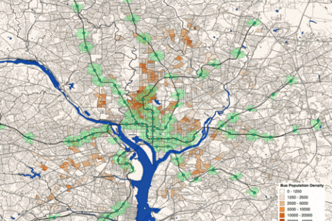
This map shows where the most bus riders live and how close they are to Metro
High population densities are generally considered necessary for frequent and direct bus service. However, not all dense populations have high bus ridership. I recently created a map of the population density of people who commute to work by bus in the DC area. Keep reading…
-

Maps of where our region’s jobs are, what types of jobs they are, and what they pay
When we talk about the densities of neighborhoods, there is a tendency to focus on how many people live in an area. But it can be equally important to talk about how many jobs are there, and what types. The maps below show where the jobs in our region are as well as how much they pay. Keep reading…