Here are the answers to whichWMATA week 77
On Tuesday, we posted our seventy-seventh photo challenge to see how well you knew Metro. I took photos of five Metro stations. Here are the answers. How well did you do?
This week, we got 18 guesses. Only three got all five. Great work, AlexC, Stephen C, and We Will Crush Peter K!
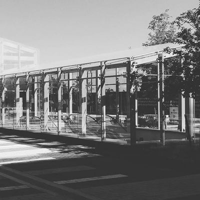
Image 1: Wiehle Avenue
The first image shows the bus loop entrance at Wiehle Avenue’s northern entrance. The greenhouse-like glass structure is a unique architectural feature in the system, unique even among its sister Silver Line stations. We’ve featured it before in week 21.
Ten knew this one.

Image 2: West Hyattsville
The second image shows the southbound platform at West Hyattsville from one of Metro’s new trains (on its first day on the Green Line). The three distinguishing attributes here are the side platforms, the fence, and the roof over the escalator bank.
Side platforms, especially at outdoor stations, are very rare, which narrows the possibilities. This fence is unique and distinctive (and was featured in week 70). One final clue is the escalator canopy, visible at far left.
Fifteen got this one right.
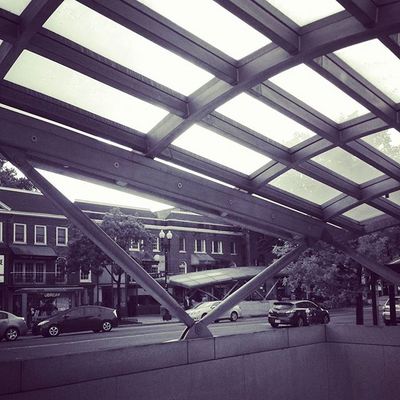
Image 3: Cleveland Park
This picture shows the pair of street entrances to Cleveland Park station stradling Connecticut Avenue. Cleveland Park station, like its neighbors to the north, Van Ness and Tenleytown, has entrances on either side of the street. But unlike at Van Ness, where they both face north, at Cleveland Park, one faces north and the other faces south. This is the only place with that arrangement.
The retail corridor here is also very distinctive, and if you’ve used the station, you might have recognized some of the buildings. Seventeen were correct.
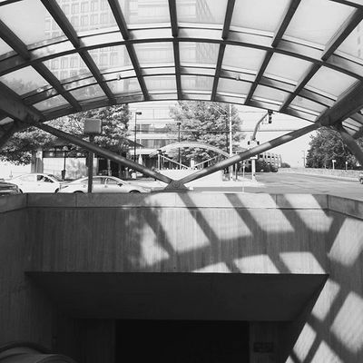
Image 4: White Flint
The fourth photo shows the underpass below Route 355 at White Flint station. The opposite direction-facing escalator canopies should have helped you narrow this down, as it’s a fairly rare arrangement. The actual station entrance is visible at center left. Other clues include the stone wall median on Marinelli Street and a barely-visible Maryland highway sign behind one of the escalator canopy supports.
Fourteen guessed the right answer.

Image 5: Metro Center
The last image proved to be quite hard — harder than I anticipated. However, it should have been possible to deduce as Metro Center given the information provided.
The most distinctive element shown in the picture is the “thanks for riding Metro” sign, which is present in only a few major “gateway” stations. In this case, the sign sits above the 12th and G entrance to the station.
As Peter K noted in his comments, the wall here is without coffer tiles and much more vertical than you’d normally see from a mezzanine. That’s because the vault is taller at Metro Center and also because this entrance is at the same level as the Red Line (it’s accessed from the Shady Grove platform), as opposed to being one level up, as the 11th and G and 13th and G entrances are, above the Red Line.
The signage also indicates an elevator to street, and given the attributes described in the paragraph above, this has to be a station where the elevator comes straight to the platform, without stopping at a mezzanine (otherwise, the vault would be more horizontal). Rosslyn and Pentagon meet that criteria, but don’t have this signage. Wheaton and Forest Glen also have direct platform-to-street elevators, but aren’t “waffle” style.
That leaves the three downtown transfer stations. L’Enfant is out because the street elevator lands at the 7th and Maryland mezzanine above the Green/Yellow Line. That leaves a tough choice between Gallery Place and Metro Center. At Gallery Place, the street elevator (actually a pair of them) land at their own fare control area in an alcove off the Glenmont platform. The entry, though, is not as wide as the featured entrance here.
At Metro Center, the street elevator shares this opening with a pair of escalators and a staircase leading to the northeast corner of 12th & G NW, very nearly atop the center of the crossvault (which is under the intersection itself).
Kudos to the six people who correctly deduced that this was Metro Center. Great work, Eric P, AlexC, Paul in SS, Stephen C, and We Will Crush Peter K!
Thanks for playing! We’ll be back in two weeks with our next quiz.
The whichWMATA quiz generally runs on the second and fourth weeks of the month, with quizzes on Tuesdays and answers on Thursdays. Information about contest rules, submission guidelines, and a leaderboard is available at http://ggwash.org/whichwmata.