Here are the answers to whichWMATA week 69
On Tuesday, we posted our sixty-ninth photo challenge to see how well you knew Metro. I took photos of five Metro stations. Here are the answers. How well did you do?
This week we got 17 guesses. Only one person got all five. Great work, Peter K!
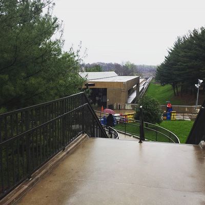
Image 1: Addison Road
This week wasn’t exactly themed, but as Peter figured out, there was a pattern. The five stations were arranged alphabetically by their first letter, A-B-C-D-E.
The first image shows the view of Addison Road from the bridge to the parking deck. You can see that this is one of the “general peak” stations. Of the general peak stations with a mezzanine above the tracks, only three are not in the median of I-66. And the setting and angle doesn’t work for Grosvenor or White Flint.
Fourteen got this one right.
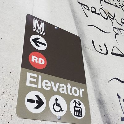
Image 2: Brookland
The second image proved to be very difficult. The sign pictured here is located on the west side of the Brookland station, mounted to a bridge pier supporting Michigan Avenue. It’s necessary because the western entrance to Brookland is not elevator-accessible. To get to the elevator, passengers have to use a circuitous route, crossing over the station on Monroe Street.
There were a few clues here, including the sign itself, which is unique as far as I am aware. Additionally, this would only be placed where the escalator and elevator entrances were separated by some distance. There are a few Red Line stations where that’s the case, including Takoma, Brookland, Woodley Park, and Bethesda.
But the sign is also mounted on a high wall with a mural. And that means it has to be Brookland. Only three people were successful on this one.

Image 3: Congress Heights
The third image shows a view of the escalators to the bus loop at Congress Heights. This is, as Peter K noted, a 180-degree view to one of the pictures featured in week 57.
The escalator canopy in the distance is only present at the three subway stations opened between 1999 and 2001. But this can only be Congress Heights. At Georgia Avenue, none of the escalator shafts have three escalators and a staircase, as this one does. And at Columbia Heights, the staircase is to the left of the three escalators. Here, it’s just visible to the right.
But the main way to differentiate Congress Heights from Columbia Heights and Georgia Avenue are the fluorescent lights hidden behind a valence mounted high on the walls. Congress Heights is the only station to have these in its escalator shafts.
Four figured this one out.

Image 4: Deanwood
I snapped the fourth photo in the mezzanine at Deanwood station. I was really taken with the play of light and shadow here when I disembarked the down escalator, so I took this picture. The unique feature is the solitary escalator penetrating the platform above. There are very few places in the system where there’s just one escalator unpaired with another escalator, stair, or elevator.
At Deanwood, the platform is accessible by an elevator and two escalators. But instead of having the escalators side-by-side they’re in-line. This is because the platform is a tiny bit narrower than other island platforms, and having two side-by-side escalators would make it too narrow where they land.
Five knew this was Deanwood.
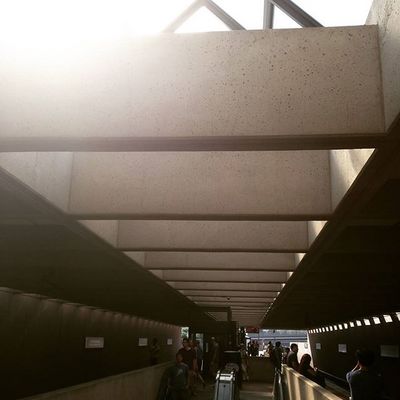
Image 5: East Falls Church
The final image was a bit easier (it was put last to match the A-B-C-D-E pattern). It’s East Falls Church. The station is clearly a general peak station. But it’s somewhat different from the others because instead of the canopy being supported by columns along the platform, it’s supported by full-height walls outside the tracks. Only Dunn Loring shares that design.
The difference from Dunn Loring is that the mezzanine at East Falls Church is under the platform, which you can tell is the case here because the escalator in the foreground is going down.
Thirteen got it right.
Next week, we’re taking a break. But we’ll be back in two weeks with five more photos for you to identify. Thanks for playing!
Information about contest rules, submission guidelines, and a leaderboard is available at http://ggwash.org/whichwmata.