Here are the answers to whichWMATA week 53
On Tuesday, we posted our fifty-third photo challenge to see how well you know Metro. I took five photos in the Metro system. Here are the answers. How well did you do?
This week we got 18 guesses. Four of you got all five correct. Great work Peter K, Alex B, MZEBE, and Sand Box John!
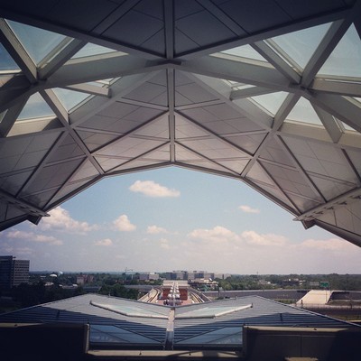
Image 1: Tysons Corner
The first image shows Tysons Corner station, viewed from the mezzanine. The architectural features clearly denote this station as one of the new Silver Line ones, and from there you should have easily been able to narrow it down to Tysons given the clues.
First, the roof is a gambrel-type, which is present only at stations where the mezzanine is above the tracks: Tysons Corner, Greensboro, and Wiehle Avenue. However, Wiehle does not have the lower winged canopy visible here at the bottom.
Additionally, this can’t be Greensboro due to the elevation. At Greensboro, the tracks rise immediately to the west. At Tysons, the mezzanine faces east, and since the station is located near the highest point in Fairfax County, the tracks descend, giving this sweeping view. Thirteen got this one right.
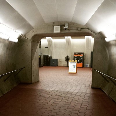
Image 2: Rosslyn
This picture shows the corridor leading to the new second entrance at Rosslyn, which we featured in week 12. The new elevator-only entrance whisks riders up to street level across from the escalator entrance. Clues here include the ceiling finish of the corridor itself and the shape of the walls of the mezzanine.
Twelve guessed correctly.

Image 3: Navy Yard
The third image shows the ceiling above the Half Street entrance to Navy Yard station. We featured this mezzanine in week 6. The main clue is the trusswork below the ceiling. It’s part of the structure of the DDOT building (55 M Street SE) and is probably recognizable if you’ve been to a Nats game.
Seven were able to figure this one out.
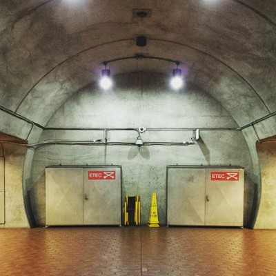
Image 4: Wheaton
The fourth image called for you to dig deep. It shows you the view at the bottom of the escalator shaft at Wheaton. The escalators here are the longest in the Western Hemisphere, bringing riders far beneath the surface.
Because the station is far down in bedrock, each track and platform is in its own tube, and that’s clear from the two entries on either side of the circular recess. And this has to be at track level because of the ETEC (Emergency Train Evacuation Cart) cabinets. Only two stations have twin tubes. But at Forest Glen, there are elevators on either side of the cross-passage between platforms.
Nine knew this was Wheaton.
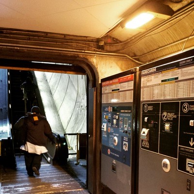
Image 5: Dupont Circle
The final image didn’t leave you with much to go on. But there was enough if you pay attention to the details. This is the bottom of the escalator shaft at Dupont Circle’s Q Street entrance. The primary clue here is the heat lamp above the fare machine.
Perhaps because the machines are located so close to an exposed and open escalator shaft or perhaps because its a vestige of some long-abandoned pilot project, Metro has installed heat lamps above these fare machines. They’re turned on during the winter, which is when I took this photo.
As far as I know, this is the only place in the system with heat lamps. Which is a real shame, because Chicago’s CTA provides heat lamps at most of their outdoor platforms to help riders cope with winter. And it can get pretty chilly on a windswept outdoor Metro platform (I’m looking at you, Silver Spring).
Seven were able to identify Dupont Circle.
Thanks to everyone for playing! Great work. Stay tuned. We’ll have five more images for you next week.