Here are some original answers to whichWMATA week 44
On Tuesday, we posted our forty-fourth photo challenge to see how well you know Metro. I took five photos in the Metro system. Here are the answers. How well did you do?
This week, we got 37 guesses. Twenty-five of you got all five right. Only twelve of those, though, figured out the theme. Those twelve are: JamesDCane, Mike B, Andrew, Peter K, mklkmkwk, coneyraven, endash, Maris, JPJ, RyanS, Julian, and MDL. Great work!
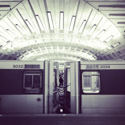
Image 1: Metro Center
A lot of you guessed the theme to be that all five stations were on the Red Line. It’s correct that they are, but that wasn’t the theme. These five stations were the first five Metro stations in the system to open. When Metro opened its doors to passengers on March 27, 1976, the Red Line ran from Rhode Island Avenue to Farragut North. Tomorrow is the 39th birthday of these five stations!
In case you’re confused, the reason two stations in this stretch are absent is because they didn’t open with the rest of the system. NoMa didn’t come along until 2004, when it became Metro’s first infill station. And Gallery Place didn’t open until December 15th of 1976 because a court injunction prevented the station from opening without a working elevator.
The first image shows the crossvault at Metro Center. You can tell this is Metro Center rather than L’Enfant Plaza because the triangular coffers go all the way to the center of the vault rather than stopping short. We taught you how to tell the difference between transfer stations in week 5. All 37 of you knew this was Metro Center.
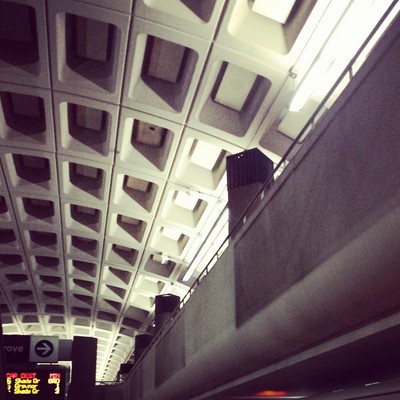
Image 2: Farragut North
The second image shows the mezzanine at Farragut North. It should have been very obvious that this was a Red Line station since you can read “Shady Grove” and “Grsvnr” on signs. This has to be Farragut North because of the configuration of the mezzanine, which is above the tracks but open above the platform. This is the inverse of the arrangement at all the other underground stations, where the mezzanine stays above the platform, leaving the tracks open to above. Thirty-four of you got this one right.
Image 3: Judiciary Square
This image shows the station entrance pylon for the eastern entrance to Judiciary Square station. In addition to the red stripe telling you this was a Red Line station, the main clue is the building in the background, One Judiciary Square. The same façade was featured in week 34. Thirty-four of you guessed correctly.

Image 4: Rhode Island Avenue
The fourth image shows the path leading to the pedestrian bridge over Rhode Island Avenue, taken from the north end of the eponymous station. This path is distinctive because it’s nearly perfectly circular and is easily visible from trains on the Red Line. Thirty-one of you recognized it.
Image 5: Union Station
The final image shows a sign at Union Station. While there aren’t many other clues here, the sign and its orientation should have been enough. The only “waffle” stations on the Red Line are the six in the stretch from Union Station to Dupont Circle. Of those stations, only two have island platforms, which you can tell must be the case here given the direction of the arrow and the vantage point near the center of the vault.
It can’t be Farragut North because that station has an almost full-length mezzanine (see image 2). Thirty-two of you figured this one out.
Thanks to everyone for playing! Great work. Stay tuned. We’ll have five more images for you next week.