Here are the answers to whichWMATA week 90
On Tuesday, we featured the ninetieth challenge to see how well you knew the Metro system. Here are the answers. How’d you do?
This week, we got 27 guesses. Nine of you got all five. Great work, Peter K, J-Train-21, Stephen C, Solomon, AlexC, JamesDCane, dpod, Travis Maiers, and We Will Crush Peter K!
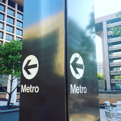
Image 1: L’Enfant Plaza
The first image features a Metro pylon directing passengers to the western entrance to L’Enfant Plaza. This entrance is inside the L’Enfant Plaza shopping concourse, and isn’t the easiest to find from the street. This pylon bridges the gap between the traditional M-capped pylon on D Street and the mall entrance.
The main clues for this image are the brutalist buildings in the backgound. They’re very iconic and should have been easiily recognizable as parts of the L’Enfant Plaza complex. 20 got it right.
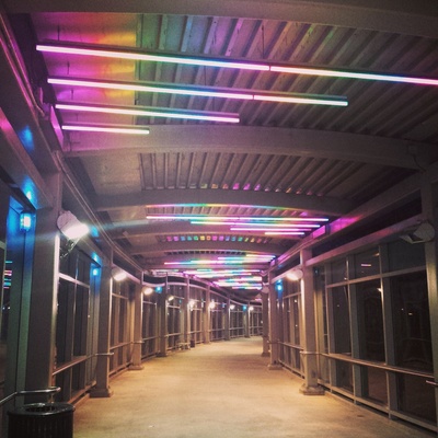
Image 2: Grosvenor
The second image shows the pedestrian bridge over Tuckerman Lane connecting Grosvenor station to the Strathmore Arts Center. The curve of this bridge was a clue, since few pedestrian bridges in the system are curved. The two obvious choices are New Carrollton and Grosvenor, which have bridges like this.
However, the bridge at New Carrollton has a sharper curve. The colored lights here are also very distinctive, but if you haven’t used the bridge at night, that might not have been helpful. 11 figured it out nonetheless.

Image 3: Braddock Road
The third image shows some new-ish signage at Braddock Road. We discussed these new platform decals in a post several months ago. This is the only station in the system with these markings.
Additional clues include the Alexandria Peak roof style (only King Street has the same canopy) and a blue marker on the train’s destination sign. 14 figured it out.

Image 4: Deanwood
This picture shows the north end of the platform at Deanwood. The surroundings here should help you eliminate all the other possibilities. The catenary masts in the background mean this must be one of the Orange Line stations on the eastern end of the line. But the lack of wires eliminates Landover and New Carrollton.
The island platform eliminates Cheverly. The houses mean that this can’t be Minnesota Avenue, since DC 295 is just west of the station. That leaves Deanwood. 21 worked out the logic correctly.
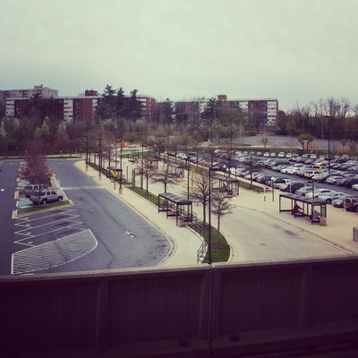
Image 5: Naylor Road
The final image shows a view from the platform at Naylor Road. The perspective here means this is an elevated station. The buildings in the distance, Lynhill Condominiums, were another clue.
Aerial images might have helped you narrow this down, by locating the bus loop and park-and-ride. 18 came to the correct conclusion.
Great work, everyone. Thanks for playing!
We’re taking a break until the end of September. So take some time to study up and we’ll see you on September 27 with week 91.
Information about contest rules, submission guidelines, and a leaderboard is available at http://ggwash.org/whichwmata.