Here are the answers to whichWMATA week 81
On Tuesday, we posted our eighty-first photo challenge to see how well you knew Metro. I took photos of five Metro stations. Here are the answers. How well did you do?
This week, we got 50 guesses. Sixteen got all five. Great work JamesDCane, AlexC, Peter K, Eric P, Stephen C, ajw4, Solomon, Sand Box John, FN, Chris H, Andy L, dpod, DavidDuck, merarch, Travis Maiers, and We Will Crush Peter K!
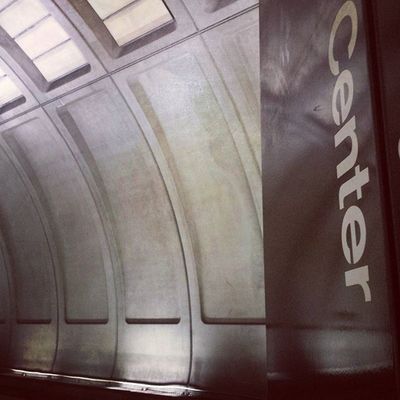
Image 1: Medical Center
The first image shows a platform pylon at Medical Center. There are five stations in the system with “center” in their name: Federal Center SW, Largo Town Center, Medical Center, Metro Center, and Mount Vernon Square/Convention Center.
However, Metro Center and Federal Center have waffle-style vaults, Largo is outdoors, and the “Center” in Mount Vernon Square wraps onto a second line of text on the pylon. That leaves Medical Center. Additionally, you can see that the vault here has only four coffers, making it Arch I, present only on the Red Line’s Shady Grove end.
Forty-four knew this one.
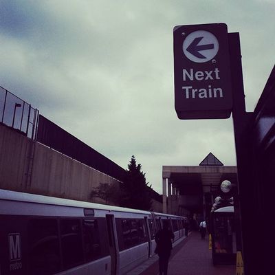
Image 2: Branch Avenue
The second image shows the southern terminal of the Green Line, Branch Avenue. There are only four high peak stations, which narrows the field considerably. The next train indicator is a hint that this station is a terminal station. It’s true that these signs are also present at some stations that used to be terminals, however none of the high peak stations are former terminals.
That leaves the two current terminals, Franconia/Springfield and Branch Avenue. However, Franconia is not in an open cut with retaining walls on either side. Additonally, the trapezoidal caps on the columns supporting the canopy are only present at Branch Avenue. That attribute was featured in week 66.
Forty-three got the right answer.
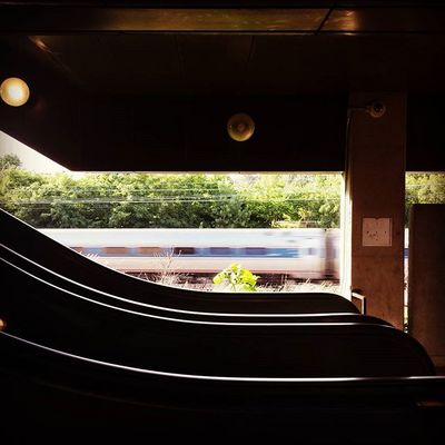
Image 3: Cheverly
The third image shows a view looking northwest from the Vienna platform at Cheverly. This image was harder than I anticipated, given the clues present.
The presence of single-level Amtrak equipment narrows this down to one of the stations along the Orange Line between Cheverly and New Carrollton, the Blue Line between Braddock Road and Franconia, and NoMa. The only Amtrak service along the Red Line is the Capitol Limited, which uses double-decker equipment.
But another clue is that the station has side platforms, which you can tell from the perspective. Finally, it’s an outdoor side-platform station with a mezzanine above the tracks. Only Cheverly fits the bill.
Only 30 got the correct result.
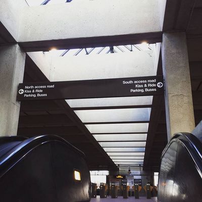
Image 4: Vienna
The fourth image shows a view from the platform escalator into the mezzanine at Vienna. The main clue is the sign overhead, which directs passengers to the north and south side access roads, with buses and parking on both sides, a situation only present at Vienna and Wiehle Avenue.
The skylights are indicative of a general peak station with a mezzanine above the tracks. And the design here is clearly older than the more modern touches on the recently-opened Silver Line.
Thirty-nine guessed correctly.
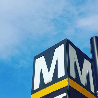
Image 5: King Street
The final image shows a station pylon at King Street. This one was a little tricky, I’ll admit, which is why I put it last. I order the five images so that they increase with (what I believe to be) difficulty from first to last.
The entrance pylon at the corner of King Street and Diagonal Road was never updated after the Blue Line was extended from National Airport to Van Dorn Street in 1991 (the Yellow Line was extended from National Airport to Huntington, including King Street, in 1983).
Many of you were either familiar with the absence of the blue stripe on this pylon or correctly deduced that the letter just below the yellow stripe was a “K”. King Street is the only station that starts with the letter K.
I know it was tempting to guess Huntington, since the first letter clearly wasn’t an E, and only Eisenhower Avenue and Huntington are served only by the Yellow Line. However, this erroneously labled pylon is distinctive, and I left enough of the K, I thought, for this to be fair game.
Twenty-four of you figured it out anyway. Great work!
Thanks for playing! We’ll be back in two weeks with our next quiz.
Information about contest rules, submission guidelines, and a leaderboard is available at http://ggwash.org/whichwmata.