Could the Yellow Line be separated? Unearthing an underwater idea

Excerpt of the 1997 Geologic Map of DC, with Metro lines overlain. Image by the author.
For a certain kind of transit nerd, the DC Metro is most famous not for its trains, architecture, or history but for its unique network topology, a consequence of the Yellow Line reverse-branching through the core of the network. A recurring proposed solution is to build new connecting tunnels to allow the Yellow Line to go elsewhere and/or let other trains use the excess capacity on its Potomac crossing.
But few proposals grapple with the true complexity of such a project, particularly the challenges posed by water and clay sediments around the tunnel. Advocates must not neglect technical challenges like these if we want to expand Metro and run the kind of service a world-class city deserves.
Why separate the Yellow Line at all?
Between public meetings, social media, and conversations with other advocates, I typically hear two broad reasons to separate the Yellow and Green Lines.
1 Service quality. As a Green Line rider, it’s frustrating to tap in Downtown and see multiple Yellow trains pass with empty seats before a nearly-full Green train shows up, especially with big event crowds. And when something goes wrong on the shared track, like happened at L’Enfant Plaza on April 17, delays can cascade to every other line. These are fundamental issues with our interlined, capacity-constrained network, so let’s build new capacity, right?
2 Cost. When the need to build new infrastructure butts into the “why is building stuff in America so expensive?” discourse, the question arises: how to boost Metro’s capacity with the least amount of costly new construction. If adding a single junction in just the right place frees up loads of unused capacity, why bother building miles of new tunnel?
Thus, reconfiguring how the Yellow Line connects to the rest of the system promises to improve Metro’s network geometry, leverage existing infrastructure, and enable better service, all with minimal construction and cost. But such ideas often ignore the physical environment around the project, which frequently renders them infeasible.
The crayonista’s (false) dilemma
“Where should this line go?” is the easiest question to answer on a fantasy map, where you can draw lines and connections wherever you want, but it’s the wrong problem for the Yellow Line. Typical WMATA fantasy maps set out to use the full 26 trains-per-hour capacity of the Yellow Line’s Potomac crossing. As illustrated below, the two typical approaches either add another interlining service over that crossing or fully separate the Yellow Line beyond the bridge.
Left: Minimal new construction, using wye tracks to allow the Yellow Line to share its Potomac crossing with another line (e.g. Silver).
Right: Minimal interlining, fully separating the Yellow, Blue, and Green lines, sending the Yellow line elsewhere on new tracks (e.g. Columbia Pike or Capitol Hill).
Source: Adapted by the author from the WMATA Metrorail map
Many versions of these two ideas have been proposed, sometimes even in combination, and Metro has repeatedly ruled them out for technical reasons. Nevertheless, the logic of “we don’t need new lines, just build wye tracks” (or vice-versa) still seems popular among austerity-minded fantasy mappers.
Unfortunately, “where would the Yellow line go?” is the wrong question. All these options require building a diverging tunnel from the current Yellow line somewhere in Southwest DC, which will be technically challenging because of… water.
Groundwater
Simply, groundwater is water below the land surface. You may recall fabulous recent articles about the history of DC’s buried streams and the flooding risks they pose. Separating the Yellow Line faces related but deeper hydrology problems.
Unless you’re on exposed bedrock, what’s beneath you right now is sediment. Dirt. Soil. Call it what you want, it’s just little pieces or “grains” of rock broken off from somewhere and deposited elsewhere. Sediment grains range widely in size, from coarse gravel through fine sand to microscopic clay. The key idea is that sediment is porous – the tiny gaps between grains provide space for water to flow into, like a sponge. As you dig a hole down into a sediment layer, at some depth, the pore spaces will be saturated with water. If you pump the water out, more water will flow in through the pores in the surrounding sediment. This is how wells work.
A schematic illustrating depth of saturation in sediment. Image by the author. 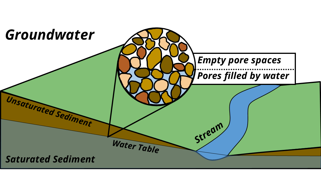
We can check how deep the groundwater is near the Yellow Line tunnels with US Geological Survey monitoring wells at nearby Buzzard’s Point, Navy Yard, and Anacostia Park. As in the below-illustrated example, their depth measurements show a groundwater level just a few feet below the local land surface.
Screenshot of USGS groundwater monitoring well map & sample data, available at this link. 
As the Yellow Line tunnel passes beneath the Washington Channel, it’s totally immersed in groundwater. Keeping this water out of the tunnel is challenging enough, but we must also consider how the water affects the surrounding sediment.
Clay
The smallest sediment grains are composed of clay minerals. Their structures are microscopic layers of flat silicate sheets, which can incorporate water molecules in between. In some (but not all) clays, incorporating this water increases the spacing between the sheets and causes the hydrated clay to swell. Significant swelling can squeeze surrounding material, causing it to shift if disturbed. It’s therefore crucial to know which clay minerals are present at an excavation site, and how much swelling and shifting may occur during excavation.
Excerpt of the Geologic Map of DC and key with Metro lines overlain. Image by Author. 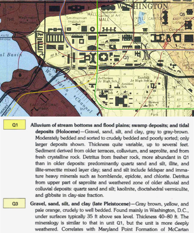
The Geologic Map of DC mentions four distinct clay minerals around the Yellow Line tunnel: illite, kaolinite, smectite, and vermiculite. Of these, the first two don’t swell, while the last two swell a LOT. Notably, the description says the swelling and non-swelling clays are interlayered, i.e. mixed together based on the rocks they originated from upstream.
When a sediment layer contains complex mixtures of clays with different hydration and swelling properties, geotechnical engineers can’t necessarily rely on existing maps or soil assessments. They may need to do site surveys to measure the spatial extent of the sediment, classify it into smaller sub-units, obtain samples for mechanical testing, and model the fluid-mechanical behavior of the sediment under different loading and water level conditions.
Construction impact
None of this is to say groundwater renders tunneling impossible; much of Metro was built in groundwater-saturated sediment, after all. The key question is: how challenging will a project be, and at what cost? A conceptually simple tunnel modification may become far more challenging if it requires rebuilding an existing structure surrounded by groundwater. Here’s a short list of potential problems:
- Digging the new tunnel from inside the existing one would require penetrating its water barrier, allowing groundwater to flow in. Therefore a shaft must be dug from the surface down to the point where the new tunnel would diverge.
- The shaft must make a seal with the existing tunnel’s water barrier, without damaging it and allowing groundwater - or the river itself - to flow in.
- Even with a good seal, water would still likely intrude into the shaft from below, and would have to be continuously pumped out.
- The excavation would require continuous monitoring to ensure sediment motion does not damage nearby structures.
- To avoid these challenges altogether would require the new tracks diverge before the tunnel submerges below groundwater; but that location in East Potomac Park is constrained by highways, the Long Bridge, and park facilities.
These geotechnical challenges are likely only part of the reason why most WMATA proposals now keep the Yellow and Green lines together, to the dismay of so many crayonistas. But is that really so bad?
How should Metro be built?
It’s been fashionable on some corners of the internet to claim one knows how to do WMATA’s job better than the professionals who work for WMATA. I find such claims tedious. We have plenty of reasons to be frustrated with an imperfect transit system, and many of us are clever enough to imagine ways to fix it. But at a technical level, those fixes are invariably far more challenging than might seem intuitive.
I don’t want Metro to be built my way. I want Metro to be built by professionals. Instead of directing our frustration at WMATA professionals, let’s direct it instead at the elected officials who’ve refused to fully fund Metro for decades while giving highways a blank check, and thus forced us to live with less-than-optimal design choices that can’t be easily fixed. There is no cheap shortcut to fully funding WMATA, nor ending the dominance of cars on DC’s roads.