A traffic engineer and a planner both study a closed freeway segment. Their conclusions are wildly different.
Let’s say you have a closed piece of freeway along your waterfront. What should you do with it? Ask many traditional traffic engineers, and they’ll likely answer with some variant of “build a lot of car lanes, maybe with some path for walkers and cyclists if there’s room.” Ask an urban planner, meanwhile, and the answer could be a more nuanced mix of buildings, parks, roads, or other pieces of a city.
Just look at what traffic engineers versus planners came up with for the piece of DC’s Southeast Freeway between the 11th Street Bridge and Barney Circle:

Four-lane road with parking and overpasses. Image from DDOT.

Concept extending DC’s street grid into the freeway. Image from the DC Office of Planning.
Advocates of “urbanism” or “livable streets” or “smart growth” often deride the “traffic engineer mindset.” This is the attitude of some (but not all) engineers who primarily build and maintain roads. These folks tend to hold an ingrained assumption that more roadway lanes are basically the answer to any mobility problem.
Meanwhile, graduates of most planning schools today will bring a wide variety of tools to the table. They’ll often look not just at how to move vehicles or even people, but whether more motion is really the best way to use some land. If people are encountering more traffic to get to jobs, one solution is to build a big transportation facility, but another approach is to create more opportunities for the people to live near the jobs, or to put the jobs near the people.
For one of the starkest illustrations of this “lane engineer” versus planner mindset dichotomy, look at the Southeast Boulevard studies in DC. There used to be a freeway running along the edge of eastern Capitol Hill to Barney Circle. Long ago, plans called for it to connect to a new bridge over the Anacostia — the Barney Circle Freeway, and part of an “inner loop” of freeways around downtown. That would have been a very damaging plan for both DC’s environment and its congestion.
DDOT’s study thinks very narrowly
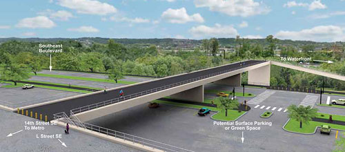
In 2005, the District Department of Transportation (DDOT) came up with a somewhat better scheme, to essentially widen the 11th Street Bridge by building a new parallel local bridge and convert the freeway segment from a four-lane freeway to a four-lane urban boulevard.
DDOT then conducted a 2014 study of options to replace the freeway segment. The study devised xis options, but all of them basically looked like near-freeways. While pedestrians and cyclists could cross to access the waterfront, and cars could turn on and off to nearby streets in some options, all of the options turned a huge expanse of pavement and empty grass into other huge expanses of pavement and empty grass, sometimes also with tour bus parking.
DDOT’s options still primarily focused around moving cars fast, and would all have created big empty spaces that would not create any actual sense of place and would be, at best, unpleasant to cross on foot.

Map of Concept 2. Images from DDOT.

Concept 2.
Concept 4A.
Planners think more creatively
Residents, led by Advisory Neighborhood Commissioner Brian Flahaven, were not happy with the narrowness of DDOT’s analysis. Instead, at Councilmember Tommy Wells’ urging, the Office of Planning stepped in to do a more open-minded study of how to use the space.
OP’s options still look at four-lane boulevards and even four-lane parkways, but with much more appealing designs like a big park next to and partly on top of the road:

Concept C2. Images from the DC Office of Planning.
Or just extend the street grid right through the site with new townhouses like the old ones:

Concept A2.
Or a new avenue fronted by larger buildings:

Concept A1.
Or a hybrid:

Concept B1.
Why 4 lanes?
But even OP’s study assumed that there need to be 4 lanes of traffic, as that’s what DDOT insists on. OP’s presentation points out that 4 lanes of traffic can be a part of residential boulevards, like New Hampshire Avenue in Petworth or East Capitol Street near Lincoln Park. However, these roads still feel much wider than others. Drivers tend to move faster here, often too fast to safely mix with other neighborhood users. New Hampshire Avenue north of Dupont, in contrast, is just one lane each way.
So why do there need to be 4 lanes of traffic? DC just effectively widened the 11th Street Bridge, adding car capacity there. Can’t there be a reduction on an adjacent street? More than that, there haven’t been any lanes for years now. It seems that a traffic pattern with zero lanes works fine.
If there’s new development, it would need a road and some lanes to get to it, but to say we need 4 because we already had 4 is circular reasoning without logic, unless you assume that more lanes are always better, and any lane once built must always remain to eternity. That’s the ingrained belief of many traditional traffic engineers, and it’s the answer I got from Ravindra Ganvir, DDOT’s deputy chief engineer, when I asked in February of 2013:
The constrained long range plan (CLRP) traffic model is assigning traffic volumes that would exceed the capacity of a two-lane facility and is showing Southeast Boulevard as a four-lane arterial facility.
Traffic models “show” traffic on a link that varies depending on what kind of link you have built, so to say that the model shows a four-lane boulevard worth of traffic when you have a freeway or boulevard in the plan is again circular. Or, as one contributor wryly paraphrased, “We are building a big road because we need a big road because there was a big road there before.”
DDOT needs to re-examine its reflexive assumption that 4 lanes is the only possibility. Regardless, this area now stands a good chance of becoming an excellent urban place now that people who think about spaces broadly and creatively got involved.